Northern Utina

Last updated
Northern Utina
Total population
Extinct as tribe
Regions with significant populations
Northern Florida east of the Suwannee River
Languages
Timucua language, Timucua proper dialect
Religion
Native
Related ethnic groups
Timucua
Reconstruction of Timucua paha (house) at the Marion County Historical Museum (formerly East Hall) Ocala Timucua paha03.jpg
Reconstruction of Timucua paha (house) at the Marion County Historical Museum (formerly East Hall)

The Northern Utina, also known as the Timucua or simply Utina, were a Timucua people of northern Florida. They lived north of the Santa Fe River and east of the Suwannee River, and spoke a dialect of the Timucua language known as "Timucua proper". They appear to have been closely associated with the Yustaga people, who lived on the other side of the Suwannee. The Northern Utina represented one of the most powerful tribal units in the region in the 16th and 17th centuries, and may have been organized as a loose chiefdom or confederation of smaller chiefdoms. The Fig Springs archaeological site may be the remains of their principal village, Ayacuto, and the later Spanish mission of San Martín de Timucua.

Contents

The Northern Utina had sporadic contact with the Europeans beginning in the first half of the 16th century. In 1539 Spanish conquistador Hernando de Soto passed through the Northern Utina region, where he captured and subsequently executed Aguacaleycuen, who may have been the principal chief at the time. Later French sources note a powerful chief in the area named Onatheaqua, who may have been a successor to Aguacaleycuen. After several decades of resistance the Northern Utina became part of the Spanish mission system in Florida in 1597. Their territory was organized as the Timucua Province, and San Martín de Timucua and three other missions were established between 1608 and 1616. The profile of the Northern Utina increased considerably as smaller peripheral provinces were incorporated into the Timucua Province, which eventually included all of northern Florida between approximately the Aucilla and St. Johns Rivers.

However, the tribe experienced significant demographic decline during the same period due to disease and other factors. They took the forefront in the Timucua Rebellion of 1665. This was put down by the Spanish, who razed their villages and relocated the populace to a series of new communities along the Camino Real or Royal Road running between the Apalachee Province and St. Augustine. In this reduced position the Northern Utina were largely powerless against raids by northern tribes allied with the English settlers such as the Creek and Yamasee, and suffered further from epidemics. They eventually moved closer to St. Augustine and mingled with other Timucua groups, losing their independent identity.

Name

The name "Northern Utina" for these people is a scholarly convention; it was never used by the people themselves or by their Spanish or Indian contemporaries. [1] [2] It is unclear what the people themselves called themselves, if they had a general name for themselves at all. The Spanish in the 17th century knew them as the Timucua and referred to the region in which they lived as the Timucua Province. Their dialect was known as Timucua (now usually called "Timucua proper"). [3] Over time smaller provinces were joined into the Timucua Province, and the name "Timucua" was applied to an increasingly wide area of northern Florida. [2]

In the 20th century, when the name Timucua came to designate all the groups who spoke the Timucuan language, scholars began to substitute the term Utina for what the Spanish had known as the Timucua Province. [2] Utina originally designated a different tribe who lived along the middle St. Johns River in the 16th century; these people were known as the Agua Dulce (Freshwater) to the Spanish in the 17th century. [2] The conflation comes from the fact that the Utina were known to their enemies as Thimogona, which may be the origin of the name "Timucua". However, the 16th-century Utina were not particularly closely related to the people of the Timucua Province. [4] Modern use of the term "Utina" has caused confusion between the 16th-century Utina chiefdom and the "Timucua proper"; as such scholars Jerald Milanich and Ken Johnson have suggested classing the two groups as eastern Utina and Northern Utina, respectively. [2]

Area

The Northern Utina lived in a region spreading roughly from the Suwannee River in the west to the St. Johns River in the east, and from the Santa Fe River northward into southern Georgia. [5] However, the main centers of the population were in the eastern Suwannee River valley. On the other side of the Suwannee, living between it and the Aucilla River (present-day Madison and Taylor Counties), were another western Timucua group, the Yustaga. [6] The Yustaga were closely related to the Northern Utina, but appear to have spoken a different dialect, perhaps Potano. [7] Beyond the Yustaga were the non-Timucuan Apalachee, who lived throughout much of the Florida Panhandle. To the south and southeast of the Northern Utina, on the other side of the Santa Fe River, were the Potano, another Timucua group. Other Timucua speakers lived to the north in Georgia, including the Arapaha. [8] Far to the east were the eastern Timucua groups, including the Saturiwa and the (eastern) Utina.

The area occupied by the Northern Utina (and the Yustaga) at the time of European contact corresponds to the area of the Suwannee Valley culture. Suwannee Valley ceramics were displaced by Leon Jefferson ceramics during the Spanish mission period (the 17th century). [9]

Early history and European contact

A suggested route for the first leg of the de Soto Expedition, based on Charles M. Hudson's 1997 map DeSoto Map Leg 1 HRoe 2008.jpg
A suggested route for the first leg of the de Soto Expedition, based on Charles M. Hudson's 1997 map
16th-century engraving by Jacques le Moyne of the Black drink ceremony among the Timucua of Florida Black drink.jpg
16th-century engraving by Jacques le Moyne of the Black drink ceremony among the Timucua of Florida

The area has been inhabited for thousands of years. In the first millennium AD the region's inhabitants participated in the Weedon Island culture, which spread across much of western Florida and beyond. From about 900 a derivative culture emerged in the Suwannee Valley area, known as the Suwannee Valley culture. This culture was common to all the Suwannee Valley peoples (the Northern Utina and the Yustaga), and as a Weedon Island derivative was closely related to the Alachua culture of the Potano. It is particularly distinguished by its ceramics. [10]

Archaeological evidence suggests that the Northern Utina lived in small community groups, perhaps representing localized chiefdoms, separated from each other by considerable distances. John E. Worth suggests that these may have been organized into a larger regional chiefdom that was continuous from at least the early days of European contact through the 17th century. [11] Early European accounts record certain chiefs as paramount over others, while during the 17th-century towns in the Timucua Province were missionized evidently based on their preeminence. [11] This may be evidence of a continuous regional chiefdom, but Worth notes it must have been much looser than more integrated Timucua chiefdoms such as the eastern Utina, the Saturiwa, or the Potano. Large-scale monuments such as platform mounds, often signs of integrated regional chiefdoms, have not been found in Northern Utina territory, and ceramic dating may vary from community to community, suggesting disunity. [12]

The Northern Utina probably encountered the survivors of the Narváez expedition in 1528, but the earliest definite historical record of them is in the accounts of Hernando de Soto's expedition, which passed through their territory in 1539. [13] These accounts indicate that the Northern Utina were more populous than any other tribe De Soto had yet encountered, and lived in distinct villages that were subordinate to a chief named Aguacaleycuen. [1] Aguacaleycuen's main village was located on the Ichetucknee River, perhaps at the Fig Springs archaeological site. [14] Aguacaleycuen was allied with (and possibly related to) another chief on the other side of the Suwannee River, Uzachile, whose chiefdom may correspond with the later Yustaga chiefdom. Upon reaching Aguacaleycuen's village De Soto captured the chief, as was his custom, intending to release him once his party had safely reached Uzachile. Subsequently some subordinate chiefs, asserting that Uzachile sought an alliance with De Soto, led the Spanish into an ambush. After a battle, De Soto executed Aguacaleycuen and other hostages and moved into Uzachile's territory, which he found already evacuated. [15]

In 1564 the French settlers of Fort Caroline heard of a powerful chief in this area named Onatheaqua. Though details are limited, this Onatheaqua may have ruled the Northern Utina chiefdom led earlier by Aguacaleycuen. [16] The French understood his chiefdom to be near that of Chief Houstaqua, whose name is probably a variant of "Yustaga", and to the east of the Apalachee. However, they believed he lived near high mountains (the Appalachian Mountains, which early Europeans believed extended to Apalachee territory). [16] The French believed Onatheaqua to be very wealthy and to have controlled access to the mountains and the strange and valuable things located there. [17]

Mission era

The Northern Utina received a number of Spanish emissaries following the 1565 establishment of St. Augustine, but they consistently rejected all Spanish overtures for several decades. Then in 1597, as part of a renewed wave of missionary effort, the Spanish sent the Timucua Christian leader Juan de Junco to the Northern Utina cacique mayor (head chief), probably at the town of Ayacuto at the Figs Springs site. [18] Alone among the other missionaries sent out that year, Juan was successful, and convinced the chief to send emissaries to St. Augustine to negotiate peace. [19] The Northern Utina rendered obedience to the Spanish crown, and the Spanish dispatched a friar to the main village of Ayacuto, where the important Mission San Martín de Timucua was established in 1608. [20] Over the next eight years at least three more missions were established in Northern Utina territory: Santa Fé de Toloca, Santa Cruz de Tarihica, and San Juan de Guacara. [21]

The profile of the Northern Utina increased substantially as smaller provinces were merged into Timucua Province, and San Martín became the principal mission and town for an increasingly wide area. However, they suffered considerable demographic decline from the epidemics that spread through Florida through the 17th century. [22] Under the principal chief of Ayacuto Lúcas Menéndez, the Northern Utina were at the forefront of the Timucua Rebellion of 1665, in which they, together with the Yustaga and Potano, revolted against the Spanish colonial government. [23] After the Spanish put down the rebellion the Northern Utina were forcibly relocated to a series of new towns along the Camino Real or Royal Road from Apalachee Province to St. Augustine. [23] This caused a severe breakdown in the social structure, and the Northern Utina were largely defenseless against raids by the Creek and Yamasee allied to the English colonies to the north. As a result surviving Northern Utina migrated closer to St. Augustine where they merged with other Timucua peoples, and were removed to Cuba in 1763. [24]

Notes

  1. 1 2 Milanich, p. 54.
  2. 1 2 3 4 5 Worth vol. I, pp. xxii–xxiv.
  3. Granberry, p. 6.
  4. Milanich, p. 46.
  5. Granberry, p. 3.
  6. Milanich, p. 55.
  7. Granberry, p. 3, 7.
  8. Milanich, pp. 55–56.
  9. Worth 2012, p. 149
  10. Worth vol. I, pp. 28–29.
  11. 1 2 Worth vol. I, p. 96.
  12. Worth vol. I, pp. 29–30.
  13. Worth vol. I, p. 30.
  14. Worth vol. I, pp. 31–32.
  15. Worth vol. I, p. 31.
  16. 1 2 Worth vol. I, p. 32.
  17. Laudonniere, Rene (2001). Bennett, Charles E. (ed.). Three Voyages. University of Alabama Press. pp. 77–78, 87. ISBN   0817311211 . Retrieved November 5, 2013.
  18. Worth vol I., p. 48.
  19. Worth vol. I, pp. 48–50.
  20. Worth vol. I, pp. 50; 67.
  21. Worth vol. I, pp. 61, 67.
  22. Swanton, p. 151.
  23. 1 2 Worth vol. II, p. 38.
  24. Worth vol. II, p. 149; 156–157.

Related Research Articles

Suwannee River 396km (246mi) river in Florida and Georgia, USA

The Suwannee River is a river that runs through south Georgia southward into Florida in the southern United States. It is a wild blackwater river, about 246 miles (396 km) long. The Suwannee River is the site of the prehistoric Suwanee Straits which separated peninsular Florida from the panhandle.

Tocobaga was the name of a chiefdom, its chief, and its principal town during the 16th century. The chiefdom was centered around the northern end of Old Tampa Bay, the arm of Tampa Bay that extends between the present-day city of Tampa and northern Pinellas County. The exact location of the principal town is believed to be the archeological Safety Harbor Site, which gives its name to the Safety Harbor culture, of which the Tocobaga are the most well-known group.

Alachua culture Archaeological culture in Florida, US

The Alachua culture is a Late Woodland Southeast period archaeological culture in north-central Florida, dating from around 600 to 1700. It is found in an area roughly corresponding to present-day Alachua County, the northern half of Marion County and the western part of Putnam County. It was preceded by the Cades Pond culture, which inhabited approximately the same area.

Potano Native American chiefdom in Florida, US

The Potano tribe lived in north-central Florida at the time of first European contact. Their territory included what is now Alachua County, the northern half of Marion County and the western part of Putnam County. This territory corresponds to that of the Alachua culture, which lasted from about 700 until 1700. The Potano were among the many tribes of the Timucua people, and spoke a dialect of the Timucua language.

The Mocama were a Native American people who lived in the coastal areas of what are now northern Florida and southeastern Georgia. A Timucua group, they spoke the dialect known as Mocama, the best-attested dialect of the Timucua language. Their territory extended from about the Altamaha River in Georgia to south of St. Augustine, Florida, covering the Sea Islands and the inland waterways, including the mouth of the St. Johns River in present-day Jacksonville and the Intracoastal. At the time of contact with Europeans, there were two major chiefdoms among the Mocama, the Saturiwa and the Tacatacuru, each of which evidently had authority over multiple villages.

Spanish missions in Florida Missions serving Native Americans in Spanish Florida

Beginning in the second half of the 16th century, the Kingdom of Spain established a number of missions throughout La Florida in order to convert the Native Americans to Christianity, to facilitate control of the area, and to prevent its colonization by other countries, in particular, England and France. Spanish Florida originally included much of what is now the Southeastern United States, although Spain never exercised long-term effective control over more than the northern part of what is now the State of Florida from present-day St. Augustine to the area around Tallahassee, southeastern Georgia, and some coastal settlements, such as Pensacola, Florida. A few short-lived missions were established in other locations, including Mission Santa Elena in present-day South Carolina, around the Florida peninsula, and in the interior of Georgia and Alabama.

Santa Fe de Toloca

Santa Fe de Toloca was a Spanish mission that existed near the Santa Fe River in the northwestern part of what is now Alachua County, Florida, United States during the 17th century. It became an important place on the camino real connecting St. Augustine with Apalachee Province, which was centered on the site of present-day Tallahassee, Florida. The site that the Santa Fe de Toloca mission occupied in the first half of the 17th century was partially excavated in the 1980s.

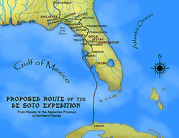
Acuera was the name of both an indigenous town and a province or region in central Florida during the 16th and 17th centuries. The indigenous people of Acuera spoke a dialect of the Timucua language. In 1539 the town first encountered Europeans when it was raided by soldiers of Hernando de Soto's expedition. French colonists also knew this town during their brief tenure (1564–1565) in northern Florida.

Timucua

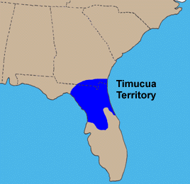
The Timucua were a Native American people who lived in Northeast and North Central Florida and southeast Georgia. They were the largest indigenous group in that area and consisted of about 35 chiefdoms, many leading thousands of people. The various groups of Timucua spoke several dialects of the Timucua language. At the time of European contact, Timucuan speakers occupied about 19,200 square miles (50,000 km2) in the present-day states of Florida and Georgia, with an estimated population of 200,000. Milanich notes that the population density calculated from those figures, 10.4 per square mile (4.0/km2) is close to the population densities calculated by other authors for the Bahamas and for Hispaniola at the time of first European contact. The territory occupied by Timucua speakers stretched from the Altamaha River and Cumberland Island in present-day Georgia as far south as Lake George in central Florida, and from the Atlantic Ocean west to the Aucilla River in the Florida Panhandle, though it reached the Gulf of Mexico at no more than a couple of points.

The indigenous peoples of Florida lived in what is now known as Florida for more than 12,000 years before the time of first contact with Europeans. However, the indigenous Floridians have largely died out with some completely by the early 18th century. Some Apalachees migrated to Louisiana, where their descendants now live; some were taken to Cuba and Mexico by the Spanish in the 18th century, and a few may have been absorbed into the Seminole and Miccosukee tribes.

Saturiwa Timucua chiefdom in Spanish Florida

The Saturiwa were a Timucua chiefdom centered on the mouth of the St. Johns River in what is now Jacksonville, Florida. They were the largest and best attested chiefdom of the Timucua subgroup known as the Mocama, who spoke the Mocama dialect of Timucuan and lived in the coastal areas of present-day northern Florida and southeastern Georgia. They were a prominent political force in the early days of European settlement in Florida, forging friendly relations with the French Huguenot settlers at Fort Caroline in 1564 and later becoming heavily involved in the Spanish mission system.

Agua Dulce people Timucua tribe in Spanish Florida

The Agua Dulce or Agua Fresca (Freshwater) were a Timucua people of northeastern Florida. They lived in the St. Johns River watershed north of Lake George, and spoke a dialect of the Timucua language also known as Agua Dulce.

The Yustaga were a Timucua people of what is now northwestern Florida during the 16th and 17th centuries. The westernmost Timucua group, they lived between the Aucilla and Suwannee Rivers in the Florida Panhandle, just east of the Apalachee people. A dominant force in regional tribal politics, they may have been organized as a loose regional chiefdom consisting of up to eight smaller local chiefdoms.

Pohoy was a chiefdom on the shores of Tampa Bay in present-day Florida in the late sixteenth century and all of the seventeenth century. Following slave-taking raids by Hichiti language-speaking Muscogee people at the beginning of the eighteenth century, the surviving Pohoy people lived in several locations in peninsular Florida. The Pohoy disappeared from historical accounts after 1739.

Ocale was the name of a town in Florida visited by the Hernando de Soto expedition, and of a putative chiefdom of the Timucua people. The town was probably close to the Withlacoochee River at the time of de Soto's visit, and may have later been moved to the Oklawaha River.

San Buenaventura de Potano was a Spanish mission near Orange Lake in southern Alachua County or northern Marion County, Florida, located on the site where the town of Potano had been located when it was visited by Hernando de Soto in 1539. The Richardson/UF Village Site (8AL100), in southern Alachua County, has been proposed as the location of the town and mission.

Arapaha was a Timucua town on the Alapaha River in the 17th century. The name was also sometimes used to designate a province or sub-province in Spanish Florida.

The Suwannee Valley culture is defined as a Late Woodland Southeast period archaeological culture in north Florida, dating from around 750 to European contact. The core area of the culture was found in an area roughly corresponding to present-day Suwannee and southern and central Columbia counties. It was preceded by the McKeithen Weeden Island culture and followed by the Spanish mission period Leon-Jefferson culture.

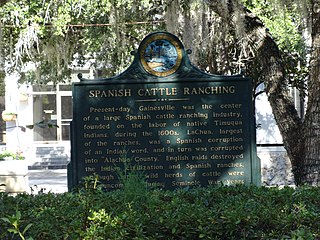
The La Chua ranch was the largest cattle ranch in Spanish Florida in the 17th century. Cattle ranching became an important part of the economy of Spanish Florida over the course of the 17th century. The La Chua ranch was founded in the middle of the 17th century, and by the end of that century accounted for one-third of the cattle in the colony. Raids by the English of the Province of Carolina and their native allies led to the abandonment of the La Chua ranch early in the 18th century.

Cattle ranching in Spanish Florida Ranchs in Florida in 17th century

Cattle ranching was an important industry in Spanish Florida in the second half of the seventeenth century. The Spanish were in Florida for almost a century before ranching became widespread in the colony. Late in the seventeenth century, ranches were located along the middle St. Johns River, in Potano Province, and in Apalachee Province. Ranches flourished despite conflicts with the native people of Florida. Attacks by the English colony, the Province of Carolina, and its native allies brought an abrupt end to ranching in Florida at the beginning of the eighteenth century.

References