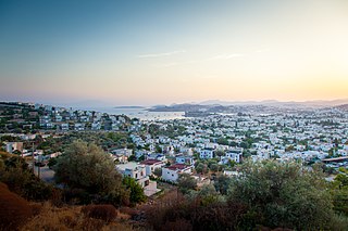
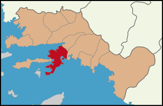
Bodrum is a small city and district of Muğla Province, Turkey. About 200 thousand people live in the district, which covers 650 km2 and includes the city. It is a port city at the entrance to the Gulf of Gökova. Known in ancient times as Halicarnassus, the city was once home to the Mausoleum at Halicarnassus, also known as the tomb of Mausolus, one of the Seven Wonders of the Ancient World.
Marmaris is a municipality and district of Muğla Province, Turkey. Its area is 906 km2, and its population is 97,818 (2022). It is a port city and tourist resort on the Mediterranean coast, along the shoreline of the Turkish Riviera.
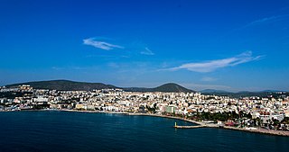
Kuşadası is a municipality and district of Aydın Province, Turkey. Its area is 265 km2, and its population is 130,835 (2022). It is a large resort town on the Aegean coast. Kuşadası is 95 km (59 mi) south of İzmir, and about 60 km (37 mi) west of Aydın. The municipality's primary industry is tourism. The mayor of the district is Ömer Günel.

Kemer is a seaside resort, municipality and district of Antalya Province, Turkey. Its area is 412 km2, and its population is 49,383 (2022). It is on the Mediterranean coast, 43 km (27 mi) west of the city of Antalya, on the Turkish Riviera.

Yalova is a market-gardening town located in northwestern Turkey on the eastern coast of the Sea of Marmara. It is the seat of Yalova Province and Yalova District. Its population is 133,109 (2022). A largely modern town, it is best known for the spa resort at nearby Termal, a popular summer retreat for residents of Istanbul.
Sulusaray or Çiftlik, in Antiquity and the early Middle Ages known as Sebastopolis or Heracleopolis (Ἡρακλειούπολις), is a town in Tokat Province in the Black Sea region of Turkey. It is the seat of Sulusaray District. Its population is 4,383 (2022). Sulusaray is about 68 km from the center of Tokat, and about 30 km from Artova town. The site is situated on a plain surrounded by mountains and the Çekerek river runs near it. The mayor is Necmettin Coruk (AKP).

Lapseki is a town in Çanakkale Province, Turkey. It is the seat of Lapseki District. Its population is 14,984 (2021). The mayor is Atilla Öztürk (iYi).

Finike, the ancient Phoenix or Phoinix also formerly Phineka, is a municipality and district of Antalya Province, Turkey. Its area is 768 km2, and its population is 49,720 (2022). It lies on the Mediterranean coast of Antalya Province in Turkey, to the west of the city of Antalya, along the Turkish Riviera. It is located on the southern shore of the Teke peninsula, and the coast here is a popular tourist destination. However, Finike is best known for its oranges, the symbol of the town.

Gölcük, formerly known as Diolkides, is a municipality and district of Kocaeli Province, Turkey. Its area is 217 km2, and its population is 175,940 (2022). The city is located at the northern gulf of Armutlu Peninsula on the coast of Gulf of İzmit, a branch of the Sea of Marmara, in the south of the province.

Kaş is a small fishing, diving, yachting and tourist town, and a municipality and district of Antalya Province, Turkey. Its area is 1,750 km2, and its population is 62,866 (2022). It is 168 km west of the city of Antalya. As a tourist resort, it is relatively unspoiled.

Kemaliye, formerly Eğin, is a town in Erzincan Province in the Eastern Anatolia region of Turkey. It is the seat of Kemaliye District. Its population is 2,536 (2022).
Koyulhisar is a town in Sivas Province of Turkey. It is the seat of Koyulhisar District. Its population is 4,041 (2022). The mayor is Bora Karrakulukcu (iYi).

Malkara is a municipality and district of Tekirdağ Province, Turkey. Its area is 1,243 km2, and its population is 50,988 (2022). It is located at 55 km west of Tekirdağ and 190 km from Istanbul. The mayor is Ulaş Yurdakul (CHP).

Polatlı is a municipality and district of Ankara Province, Turkey. Its area is 3,618 km2, and its population is 128,378 (2022). It is 80 km west of the Turkish capital Ankara, on the road to Eskişehir. Its elevation is 853 m.

Sungurlu is a town in Çorum Province in the Black Sea Region of Turkey, located 72 km south-west of the city of Çorum. It is the seat of Sungurlu District. Its population is 30,275 (2022). The mayor is Muhsin Dere (MHP).

Beypazarı is a municipality and district of Ankara Province, Turkey. Its area is 1,697 km2, and its population is 48,357 (2022). It is approximately 100 km northwest of the city of Ankara. The elevation in the center is 675 m (2,215 ft). It used to be an important city in Asia Minor in ancient times.

Kıyıköy, historically Medea, is a town (belde) in the Vize District, Kırklareli Province, Turkey. Its population is 2,160 (2022). It is on the Black Sea coast, 36 km (22 mi) from Vize and 95 km (59 mi) away from Kırklareli. It became a municipality in 1987.

Kayalıpınar is a village in Yıldızeli District, in Sivas Province, Turkey. Its population is 66 (2022). It is a Hittite archaeological site, under excavation since 2004. It is identified with the ancient Samuha settlement.
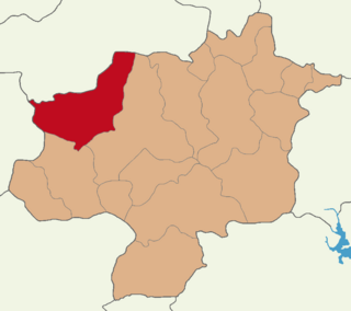
Yıldızeli District is a district of the Sivas Province of Turkey. Its seat is the town of Yıldızeli. Its area is 2,529 km2 (976 sq mi), and its population is 28,972 (2022).
Güneykaya is a town (belde) in the Yıldızeli District, Sivas Province, Turkey. Its population is 1,347 (2022).

