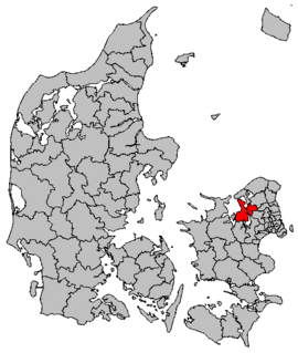
Frederikssund Kommune is a municipality on the shores of Roskilde Fjord in the northern part of the island of Zealand (Sjælland) in eastern Denmark. On 1 January 2007, the municipality was enlarged to include the old Jægerspris, Slangerup, and Skibby municipalities. It now covers an area of 250 km² and has a population of 44,401. As of 1 January 2014 its mayor is John Schmidt Andersen, a member of the agrarian liberal Venstre political party. Frederikssund municipality belongs to Region Hovedstaden.

Hohenzollernplatz is an U-Bahn station in Munich on the U2. The station is also served by routes and of the Munich tramway.

Fernmeldeturm Koblenz is a free standing telecommunications tower on the mountain Kühkopf near Koblenz, Germany. It was built between 1972 and 1976. The Fernmeldeturm Kühkopf is 260.7 m (855.3 ft) high and not accessible to visitors.

Wieck is a village in the administrative district of Gmina Czersk, within Chojnice County, Pomeranian Voivodeship, in northern Poland. It lies approximately 12 kilometres (7 mi) north-east of Czersk, 40 km (25 mi) north-east of Chojnice, and 66 km (41 mi) south-west of the regional capital Gdańsk.
Górczyca is a village in the administrative district of Gmina Lwówek Śląski, within Lwówek Śląski County, Lower Silesian Voivodeship, in south-western Poland. Prior to 1945 it was in Germany.
Nowojowice is a village in the administrative district of Gmina Żórawina, within Wrocław County, Lower Silesian Voivodeship, in south-western Poland. Prior to 1945 it was in Germany. It lies approximately 8 kilometres (5 mi) south of Żórawina and 24 km (15 mi) south of the regional capital Wrocław.

Young America is an unincorporated community in Deer Creek Township, Cass County, Indiana.

New Corydon is an unincorporated community in Wabash Township, Jay County, Indiana.

Cəmilli is a village in the Kalbajar Rayon of Azerbaijan.
Esmond Township is a civil township in Benson County, North Dakota, United States. As of the 2000 census, its population was 50.
Pańska Łaska is a village in the administrative district of Gmina Trzcianka, within Czarnków-Trzcianka County, Greater Poland Voivodeship, in west-central Poland. It lies approximately 4 kilometres (2 mi) north-west of Trzcianka, 21 km (13 mi) north-west of Czarnków, and 81 km (50 mi) north-west of the regional capital Poznań.
Osiek is a village in the administrative district of Gmina Koziegłowy, within Myszków County, Silesian Voivodeship, in southern Poland. It lies approximately 6 kilometres (4 mi) south-east of Koziegłowy, 7 km (4 mi) west of Myszków, and 39 km (24 mi) north-east of the regional capital Katowice.
Żabiak is a settlement in the administrative district of Gmina Namysłów, within Namysłów County, Opole Voivodeship, in south-western Poland. It lies approximately 6 kilometres (4 mi) west of Namysłów and 50 km (31 mi) north-west of the regional capital Opole.

Dřínov is a village and municipality in Kladno District in the Central Bohemian Region of the Czech Republic.
Nehatu is a village in Lääneranna Parish, Pärnu County, in western Estonia.

Zafaran-e Olya is a village in Mansuri Rural District, Homeyl District, Eslamabad-e Gharb County, Kermanshah Province, Iran. At the 2006 census, its population was 634, in 147 families.
Zafaran-e Sofla is a village in Mansuri Rural District, Homeyl District, Eslamabad-e Gharb County, Kermanshah Province, Iran. At the 2006 census, its population was 40, in 8 families.
Zafaran Kola is a village in Gatab-e Shomali Rural District, Gatab District, Babol County, Mazandaran Province, Iran. At the 2006 census, its population was 580, in 151 families.
Sakhvid Rural District is a rural district (dehestan) in Nir District, Taft County, Yazd Province, Iran. At the 2006 census, its population was 1,747, in 565 families. The rural district has 36 villages.
Cooperdale is an unincorporated community in Coshocton County, in the U.S. state of Ohio.