
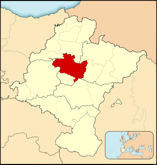
Zabalza is a town and municipality located in the province and autonomous community of Navarre, northern Spain.
Zabalza is a town and municipality located in the province and autonomous community of Navarre, northern Spain.

Meñaka is a town and municipality located in the province of Biscay, in the autonomous community of Basque Country, northern Spain.

Basaburua is a town and municipality located in the province and autonomous community of Navarre, northern Spain.
Imotz is a town and municipality located in the province and autonomous community of Navarre, northern Spain.
Mennon, Saskatchewan, is a community in mid-southern Saskatchewan, Canada. It is approximately 42 km (26 mi) away from Saskatoon, Saskatchewan. At one time the community was much larger than Saskatoon, however, it dropped in population when the railroad pulled out to go to other settlements.

Kagalaska Island is an island in the Andreanof Islands of the Aleutian Islands of Alaska.

Engelmann Township is located in St. Clair County, Illinois. As of the 2010 census, its population was 726 and it contained 288 housing units.

London Square is a public space in the center of Tel Aviv, named after London, England as an act of honour for the British people and especially the Londoners who stood in the sustained bombing of the United Kingdom by Nazi Germany during World War II—The Blitz.

Lotus is an unincorporated community in El Dorado County, California. It is located 1 mile (1.6 km) west of Coloma, at an elevation of 722 feet.
The Cuenca de Pamplona is a comarca in Navarre, Spain. The Spanish word cuenca means 'basin', referring to a 'territory surrounded of mountains or hills'. The metropolitan area of Pamplona grows in detriment of the ceralistic countryside.

Deep Creek is a census-designated place (CDP) in Accomack County, Virginia, United States. The population as of the 2010 Census was 115.
Sutter Hill is an unincorporated community in Amador County, California. It is located 7.25 miles (11.7 km) south-southeast of Plymouth, at an elevation of 1562 feet.
Oungre is a hamlet in the Canadian province of Saskatchewan. Listed as a designated place by Statistics Canada, the hamlet had a population of 15 in the Canada 2006 Census.
Chili Bar is a former settlement and mining camp in El Dorado County, California. It was located on the South Fork of the American River 4.5 miles (7.2 km) east-southeast of Coloma.

Schantzenfeld is a hamlet in Saskatchewan, Canada. There are 2 small businesses located in Schantzenfeld.
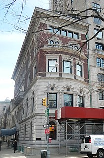
The Edward J. Berwind House is a mansion located on 2 East 64th Street and Fifth Avenue in the Upper East Side in New York City.
Pedro María Zabalza Inda is a Spanish former football midfielder and manager.
January Wash, an arroyo, tributary to El Dorado Canyon, in Clark County, Nevada. Its mouth is located at its confluence with El Dorado Canyon at an elevation of 2375 feet. Its source in the Eldorado Mountains near the Rich Hill Mine at 35°40′43″N114°50′14″W.
Capulin Peak is a summit in Rio Arriba County, New Mexico. It reaches an elevation of 9199 feet / 2804 meters. Its former name in the Tewa language of the nearby Puebloan peoples was Abepin. Its Spanish name was Cerro Capulin, Capulin meaning Choke Cherry. The Armijo Route of the Old Spanish Trail ran westward at the foot of the peak at its south. This route is now closely followed or paralleled by New Mexico, New Mexico State Road 96.
El Chaparral is a census-designated place (CDP) in Starr County, Texas, United States. It is a new CDP for 2010 census with a population of 464. It was formed along with Santa Rosa CDP from the old Santa Cruz CDP.
Craney Hill State Forest is in Henniker, New Hampshire. It comprises 21 acres (8.5 ha) along the south side of Old Concord Road and is also bordered by gravel pits on two sides and private land.
Coordinates: 42°46′02″N1°48′06″W / 42.76722°N 1.80167°W
| This article about a location in Navarre, Spain, is a stub. You can help Wikipedia by expanding it. |