
Luquin (Basque : Lukin) is a town and municipality located in the province and autonomous community of Navarre, northern Spain. It is thought to be one of the few villages with a community owned swimming pool
Luquin (Basque : Lukin) is a town and municipality located in the province and autonomous community of Navarre, northern Spain. It is thought to be one of the few villages with a community owned swimming pool
Columbia Township is a civil township of Tuscola County in the U.S. state of Michigan. The population was 1,229 at the 2020 census.

Flanders is a hamlet and a census-designated place (CDP) in Suffolk County, New York, United States. The population was 4,472 at the 2010 census. It is the location of the Big Duck.

Italy is a town located in Yates County, New York, United States. As of the 2010 census, the town had a total population of 1,141. The town takes its name from the country of Italy.

Plattsburgh is an unincorporated community in central Harmony Township, Clark County, Ohio, United States. It is located along State Route 54 near the headwaters of the North Fork Little Miami River.

Igúzquiza is a town and municipality located in the province and autonomous community of Navarre, northern Spain. Igúzquiza is 4 km from Estella and 50.03 km from the capital of the community, Pamplona. It covers an area of 18.02 km² and Its population in 2023 was 301 inhabitants.

Bankview is a neighbourhood in the southwest quadrant of the city of Calgary, Alberta.

Coronado Heights is a hill northwest of Lindsborg, Kansas, United States. It is alleged to be near the place where Francisco Vásquez de Coronado gave up his search for the seven cities of gold and turned around to return to Mexico. Coronado Heights is one of a chain of seven sandstone bluffs in the Dakota Formation and rises approximately 300 feet.
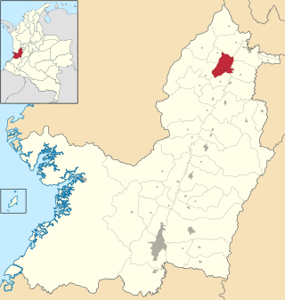
Toro is a city and municipality located in the north of the department of Valle del Cauca, Colombia. The climate is warm.
Flanders is an unincorporated community in Lafayette Parish, Louisiana, United States. It lies at the intersection of Louisiana Highways 339 and 92.

Tsalenjikha is a town in Samegrelo-Zemo Svaneti region of western Georgia with the population of 3,847 (2014). It is located on the river Chanistsqali. Historically, Tsalenjikha functioned as one of the residences of the Dadiani princess of Mingrelia and a bishopric seat with a medieval cathedral of the Savior.
Big Beaver is an organized hamlet in the Canadian province of Saskatchewan. It is situated at the junction of Highways 18 and 34 in the Rural Municipality of Happy Valley No. 10. North of Big Beaver along Highway 34 is the Big Muddy Badlands. South of town, at the end of Highway 34, is the now closed US border crossing of Big Beaver. The port was closed to northbound traffic in 2011 and to southbound traffic in 2013.
Sierra Springs is an unincorporated community in El Dorado County, California. It lies at an elevation of 3323 feet.

Xetulul is a theme park in Guatemala. It is located in the Retalhuleu Department in the southwest of the country. Opening in 2002, Xetulul is the third-largest amusement park in Latin America, after Beto Carrero World in Penha, Santa Catarina, Brazil and Six Flags México near Mexico City, Mexico. Xetulul is associated with the nearby Xocomil water park, which opened in 1997, and together the two parks receive over one million visitors every year, making the parks the most popular tourist attraction in the country.

Plattekill is a hamlet in Ulster County, New York, United States. The population was 1,296 at the 2020 census. The community, as is the town, is named after a local stream, the Platte Kill.
Creek, also known as Georgia Camp, is an unincorporated community in Houston County, Texas, United States. Creek is located on Farm to Market Road 1280, 15 miles (24 km) southwest of Crockett. The community was founded after the Civil War, and by the 1880s it had a school and a post office. At its peak in the 1890s, the community had a population of 150 and many businesses; by the 1990s, its population was scattered and it had only retained its church and cemetery.
Shallowford is an unincorporated community in Unicoi County, in the U.S. state of Tennessee.

Generally, the Chicago Harbor comprises the public rivers, canals, and lakes within the territorial limits of the City of Chicago and all connecting slips, basins, piers, breakwaters, and permanent structures therein for a distance of three miles from the shore between the extended north and south lines of the city. The greater Chicago Harbor includes portions of the Chicago River, the Calumet River, the Ogden Canal, the Chicago Sanitary and Ship Canal, Lake Calumet, and Lake Michigan.
Hobart is an extinct town in Lincoln County, in the U.S. state of Missouri. The GNIS classifies it as a populated place.
Mount Forest Trails is an unincorporated community located in Clermont County, Ohio, United States.

Swan Island is an island in the Detroit River. It is in Wayne County, in southeast Michigan. Its coordinates are 42°05′57″N83°10′27″W, and the United States Geological Survey gave its elevation as 581 ft (177 m) in 1980. A 1982 report from the U.S. Fish and Wildlife Service said that white bass had been spawning at the island since the 1920s.
42°36′42″N2°05′57″W / 42.61167°N 2.09917°W
| | This article about a location in Navarre, Spain, is a stub. You can help Wikipedia by expanding it. |