
Hancock is a village in Delaware County, New York, United States. The population was 908 at the 2020 census. The village is in the west part of the town of Hancock at the junction of NY Routes 17 and 97.

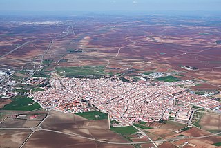
Belorado is a village and municipality in Spain, belonging to the Province of Burgos, in the autonomous community of Castile-Leon. It has a population of approximately 2,100 inhabitants. It is also known for being a city in the Way of Saint James.
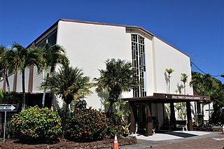
Holy Trinity is a Roman Catholic church located in Honolulu, Hawaiʻi.
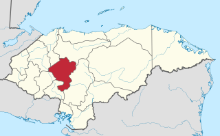
La Libertad is a municipality in the Honduran department of Comayagua.
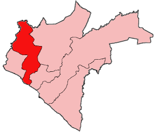
Nueva Armenia is a municipality in the Honduran department of Francisco Morazán.

Ordizia, formerly known as Villafranca de Ordizia, is a town and municipality located in the Goierri region of the province of Gipuzkoa, in the autonomous community of the Basque Country, northern Spain.
Owensgrove is one of six districts located in Grand Bassa County, Liberia.
Meira is a municipality in the Galician province of Lugo. It is in the northwest of the province, including the Terra Chá and the Serras Orientais to the west of the Serra de Meira. The most popular festivals are those of the candles, carnival, corpus, Santa Maria, San Roque, and the Festa da Malha.
Villafranca de los Barros is a municipality in the province of Badajoz, Extremadura, Spain. It has a population of 13,329 and an area of 104 km2.

Villafranca Montes de Oca is a municipality, former medieval bishopric and present Latin titular see located in the province of Burgos, Castile and León, northern Spain. According to the 2005 census (INE), the municipality has a population of 164 inhabitants.
Villafranca de Ebro is a municipality located in the province of Zaragoza, Aragon, Spain. According to the 2004 census (INE), the municipality has a population of 684 inhabitants.

Villafranca de Duero is a municipality located in the province of Valladolid, Castile and León, Spain. According to the 2004 census (INE), the municipality has a population of 374 inhabitants.
Spring Lawn is an historic home on Kemble Street in Lenox, Massachusetts. Built in 1904 for John Alexandre, the mansion is considered a unique blend of Beaux-Arts and Classical Revival styles. Spring Lawn was designed by Guy Lowell who was also the architect of the Museum of Fine Arts, Boston and the New York Supreme Court courthouse. The property has seen many uses over the years, including acting as the home of the National Music Foundation, Carl H. Stevens Jr.'s Bible Speaks College, and Shakespeare & Company. Today, there are plans to convert the mansion and its surrounding property into a luxury resort.

The Bardenas Reales is a semi-desert natural region, or badlands, of some 42,000 hectares in southeast Navarre (Spain). The soils are made up of clay, chalk, and sandstone and have been eroded by water and wind creating surprising shapes, canyons, plateaus, tabular structures, and isolated hills, called cabezos. Bardenas Reales lacks urban areas, vegetation is scarce and the many streams that cross the territory have a markedly seasonal flow, staying dry most of the year.
Acopampa or Aqupampa is one of eleven districts of the province of Carhuaz in Peru.

Marcará District is one of eleven districts of the Carhuaz Province in Peru.
Puras de Villafranca, also known as Puras, is a village in the municipality of Belorado in the region of Montes de Oca, with historical links to Villafranca Montes de Oca.

The Battle of Río Burbia or the Battle of the Burbia River was fought in the year 791 between the troops of the Kingdom of Asturias, commanded by King Bermudo I of Asturias, and the troops of the Emirate of Córdoba, led by Yusuf ibn Bujt. The battle occurred in the context of the Ghazws of Hisham I against the Christian rebels of the northern Iberian Peninsula. The battle took place near the Río Burbia, in the area which is today known as Villafranca del Bierzo. The battle resulted in a victory for the Emirate of Cordoba.
Unionville is a suburban community in the Delaware Valley located on Pennsylvania Route 309. It is mainly in Hatfield Township, Montgomery County but also in Hilltown Township, Bucks County, Pennsylvania, United States.
Villafranca Station was an ESTRACK satellite ground station in Spain, 30 kilometres (19 mi) north from the city of Madrid in a Villanueva de la Cañada, within the area of European Space Astronomy Centre.


