
Myanmar, officially the Republic of the Union of Myanmar and also rendered Burma, is a country in Southeast Asia. It is the largest country by area in Mainland Southeast Asia and has a population of about 55 million. It is bordered by India to its west, Bangladesh to its southwest, China to its northeast, Laos and Thailand to its east and southeast, and the Andaman Sea and the Bay of Bengal to its south and southwest. The country's capital city is Naypyidaw, and its largest city is Yangon.

Yangon, formerly romanized as Rangoon, is the capital of the Yangon Region and the largest city of Myanmar. Yangon served as the capital of Myanmar until 2006, when the military government relocated the administrative functions to the purpose-built capital city of Naypyidaw in north central Myanmar. With over five million people, Yangon is Myanmar's most populous city and its most important commercial centre.

Myanmar is divided into 21 administrative divisions, which include seven regions, seven states, one union territory, one self-administered division, and five self-administered zones.

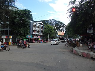
Lashio is the largest town in northern Shan State, Myanmar, about 200 kilometres (120 mi) north-east of Mandalay. It is situated on a low mountain spur overlooking the valley of the Yaw River. Loi Leng, the highest mountain of the Shan Hills, is located 45 km (28 mi) to the south-east of Lashio.
Myitkyina is the capital city of Kachin State in Myanmar (Burma), located 1,480 kilometers (920 mi) from Yangon, and 785 kilometers (488 mi) from Mandalay. In Burmese it means "near the big river", and Myitkyina is on the west bank of the Ayeyarwady River, just below 40 kilometers (25 mi) from Myit-son of its two headstreams. It is the northernmost river port and railway terminus in Myanmar. The city is served by Myitkyina Airport.

Pyin Oo Lwin or Pyin U Lwin, formerly and colloquially referred to as Maymyo, is a scenic hill town in the Mandalay Region, Myanmar, some 67 kilometers (42 mi) east of Mandalay, and at an elevation of 1,070 metres (3,510 ft). The town was estimated to have a population of around 255,000 in 2014.

Kyaukse is a town and the capital of Kyaukse District in Mandalay Region, Myanmar. Lying on the Zawgyi River, 25 miles (40 km) south of Mandalay, it is served by the Mandalay-Yangon (Rangoon) railway. The first Myanmar probably settled in the area about 800, and local 12th- and 13th-century inscriptions refer to Kyaukse as “the first home”. Remains of pagodas and old cities are found throughout the area. The Shwethalyaung Pagoda, built by King Anawrahta (1044–77), is located in Kyaukse.

Hinthada is a city located on the Irrawaddy River in Ayeyarwady Region, Burma (Myanmar). It is organized as Hinthada Township and Hinthada District, which includes the adjacent townships of Lemyethna and Zalun. In the 1983 census the city itself had a population of 82,005. By 2010 it had grown to 170,312. The trade of locally grown rice and grain goes through the port of Hinthada.
Tamu is a town in the Kabaw Valley in the Sagaing Region in north-west Myanmar near the border with the eastern Indian state of Manipur. It is a principal town of the Kabaw Valley and the seat of administration for the Tamu Township. Opposite the Indian town of Moreh, it is home to an official border trade posts with India, which opened on 12 April 2005. In 2022, total trade volume at the border post stood at US$15.134 million.

Myawaddy is a town in southeastern Myanmar, in Kayin State, close to the border with Thailand. Separated from the Thai border town of Mae Sot by the Moei River, the town is the most important trading point between Myanmar and Thailand. Myawaddy is 170 kilometres (110 mi) east of Mawlamyine, the fourth largest city of Myanmar, and 426 kilometres (265 mi) northwest of Bangkok, the capital of Thailand.

Districts are the second-level administrative divisions of Myanmar. They are the subdivisions of the regions and states of Myanmar. According to the Myanmar Information Management Unit (MIMU), as of December 2015, there are 76 districts in Myanmar, which in turn are subdivided into townships, then towns, wards and villages.

Hinthada District is a district of Ayeyarwady Division, Myanmar.
Danubyu Township, also spelt Danuphyu and formerly as Donabyu, is a township of Maubin District in the Ayeyarwady Region of Burma (Myanmar). Danubyu Township is known as the death place of the general Maha Bandula at Danubyu Fort effectively ending the First Anglo-Burmese War by forcing the Burmese to surrender to the British.

Zalun Township is a township of Hinthada District in the Ayeyarwady Division of Myanmar. The township consists of Zalun town, which has five wards, and 462 villages.
Htantabin Township is a township located on the western border of central Yangon Region, Burma (Myanmar). Its administrative seat is Htantabin which is located in the southeastern part of the township on the western bank of the Hlaing River just south of its confluence with the Kokkowa River.
Duya is a town in Zalun Township of Hinthada District in the Ayeyarwady Region of south-western Burma (Myanmar). Duya is located on the west side of Duya Lake, an oxbow lake of the Irrawaddy. It is about 10 kilometres (6.2 mi) south of Hinthada and 13 kilometres (8.1 mi) north of Zalun.

The Rohingya conflict is an ongoing conflict in the northern part of Myanmar's Rakhine State, characterised by sectarian violence between the Rohingya Muslim and Rakhine Buddhist communities, a military crackdown on Rohingya civilians by Myanmar's security forces, and militant attacks by Rohingya insurgents in Buthidaung, Maungdaw, and Rathedaung Townships, which border Bangladesh.

The Myanmar Civil War, also known as the Burmese Civil War, Burmese Spring Revolution, or People's Defensive War, is an ongoing civil war following Myanmar's long-running insurgencies, which escalated significantly in response to the 2021 military coup d'état and the subsequent violent crackdown on anti-coup protests. The exiled National Unity Government and major ethnic armed organisations repudiated the 2008 Constitution and called instead for a democratic federal state. Besides engaging this alliance, the ruling government of the State Administration Council, or SAC, also contends with other anti-SAC forces in areas under its control. Hannah Beech of The New York Times observed the insurgents are apportioned into hundreds of armed groups scattered across the country.
Hlaingthaya (Yangon)-Hinthada Railway is a railway line operated by Myanma Railways under the Ministry of Transport and Communications. This railway connects towns on the eastern side of the Ayeyarwady River, such as Yangon (Hlaingthaya), with towns on the western side, including Nyaungdon, Sakkaw, Zalun, and Hinthada. The railway line stretches approximately 90 miles, with the journey between Yangon and Hinthada taking about six hours. Two rail services were introduced on May 24, 2014.

