Pathein Township

Last updated
Pathein Township
ပုသိမ်မြို့နယ်
Pathein City 2.jpg
Chit Thu Myar Island Ngwe Saung Beach.jpg
Top: View of Pathein City.
Bottom: Chithumyar Island, Ngwesaung
Pathein tsp in Pathein district.svg
Location in Pathein district
Coordinates: 16°46′N94°43′E / 16.767°N 94.717°E / 16.767; 94.717
CountryFlag of Myanmar.svg  Myanmar
Region Flag of Ayeyarwady Region.svg  Ayeyarwady Region
District Pathein District
Capital Pathein
Area
  Total644.88 sq mi (1,670.23 km2)
Elevation
27 ft (8.3 m)
Population
 (2019) [1]
339,212
  Ethnicities
Time zone UTC+6:30 (MST)

Pathein Township (formerly Bassein West Township) is a township of Pathein District in the Ayeyawady Region of Myanmar. The administrative seat of the Township, District and Region is Pathein. The city of Pathein is the largest city in the Region and has historically been an important center of trade, including a deepwater port. [2]

Contents

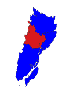
Pathein Township is located in west-central Ayeyarwady Region and in the central part of Pathein District. The Township includes Ngwesaung Subtownship and Shwethaungyan Subtownship, both unofficial divisions used by the Township for statistical and administrative ease. Shwethaungyan subtownship spans the border between Pathein Township and Thabaung Township to its north. To its east, it borders Kangyidaunt Township and to its south it borders Ngapudaw Township. The Bay of Bengal forms the Township's western shore.

Communities

The Township is divided into 1 city and 3 towns, 25 urban wards, 54 village tracts and 285 villages. It separately contains two subtownships.

Pathein is the main city of the Township and is located on the Pathein River and had a population of 172,923 in 2019. [1] The area of Pathein township outside of the two subtownships, sometimes called the "Town of Pathein" was 287,071 in 2014. [3]

The Town has two subtownships. The town of Ngwesaung lies within Ngwesaung Subtownship on the coast, is divided into 4 wards. Within Shwethaungyan Subtownship, there are two towns- Shwethaungyan and Chaungtha each divided into 3 wards. [4] Ngwesaung and Chaungtha are both beach resorts serving mostly tourists from Yangon and Pathein.

Geography

Pathein Township is located in the Irrawaddy Delta, spans over the southern edges of the Arakan Mountains and includes a significant coastline with the Bay of Bengal. Most of the Townships is low-lying delta plains. Steep forested mountains characterize the western quarter of the township starting 12 miles west of the Pathein River. The Township has 8 islands, mostly in the vicinity of Ngwesaung and Chaungtha beaches.

The Ngawun, Pathein and Thandwe Rivers are the most major waterways of the township. Besides major rivers, the Township contains 328 smaller streams. The highest peak within the township is Mount Kyarlay at an elevation of 844 feet (257 m). Pathein Township is located in a mountainous tropical zone with a heavy monsoon presence, seeing 129 days of rain in an average year. Average highs and lows range between 40.7°C and 15.0°C with lows mostly in the Arakan Mountains.

The western part of the township is largely undeveloped and is home to a diverse variety of flora and fauna. The 39 primary tree species identified by the township include trees include hardwoods like teak and Burmese ironwood, fruit trees like mango and tamarind as well as coastal trees like Coconut trees. Prominent animals in the township include elephants, gaur, black bears, iguana, water buffalo, deer, hog badgers and many more. [1]

Economy

As the administrative capital of the Region, Pathein Township enjoys both political and economic prominence with strong infrastructure for trade on land and water. However, the primary industry of the township is agriculture. The primary crop is rice, with the largest export market being Yangon Region and Upper Burma. Other crops include fruits like bananas and coconuts. The animal husbandry industry in the township is growing with many goat herders shifting into pork, poultry or dairy. The township also has a sizeable fishing industry as well as fish hatcheries and fish farms. 27.4% of the township is wildlife preserve or undeveloped lands, mostly in the west.

The primary produce of Pathein's industrial sector is fabrics and textiles within the Pathein Industrial Zone. Beyond the textile industry, there are many traditional artisan workshops like hand-made buckets and the iconic Pathein parasols. [5] Rice milling and charcoal production are other traditional industry present in the Pathein city area. The Township has one airport - Pathein Airport and a major rail terminal at the end of four intercity railroads. [1]

Demographics

Historical Population
YearPathein Township±%
1973     
1983     
2014 287,071    
2018 339,015+18.1%
2019 339,212+0.1%
Source: Ministry of Labor, Immigration, and Population data, [3] General Administration Department

Pathein Township has two distinct characteristic demography with an urban and suburban deltaic east and a much more rural mountainous west. 51% of the overall Township lives within a city or town, with 58% of the population in the East living in the City of Pathein. [3] The most common religion is Buddhism at 86.9% with Christianity second at 10.8%. There are 76,575 households; the mean household size was 4.4 people. The median age was 24.5 years, and 93 males per 100 females. [1]

Notes

  1. 1 2 3 4 5 Myanmar Information Management Unit (September 2019). Pathein Myone Daethasaingyarachatlatmya ပုသိမ်မြို့နယ် ဒေသဆိုင်ရာအချက်လက်များ [Pathein Township Regional Information](PDF) (Report). MIMU. Retrieved October 24, 2022.
  2. Parrot-Sheffer, Chelsey. "Pathein". Britannica. Retrieved 2022-10-24.
  3. 1 2 3 "Pathein Township Report" (PDF). 2014 Myanmar Population and Housing Census. October 2017.
  4. "Pathein Township Profile" [ permanent dead link ] March 2009, Myanmar Information Management Unit (MIMU)
  5. "Pathein (Bassein)". Journeysmyanmar.com. Retrieved August 21, 2009.

Related Research Articles

<span class="mw-page-title-main">Ayeyarwady Region</span> Region of Myanmar

Ayeyarwady Region is a region of Myanmar, occupying the delta region of the Ayeyarwady River. It is bordered by the Rakhine State to the northwest, the Bago Region to the north, Bago Region and Yangon Region to the east, and the Bay of Bengal to the south and west.

<span class="mw-page-title-main">Administrative divisions of Myanmar</span> First-level political subdivisions of Myanmar

Myanmar is divided into 21 administrative divisions, which include seven regions, seven states, one union territory, one self-administered division, and five self-administered zones.

<span class="mw-page-title-main">Pathein</span> Capital of Ayeyarwady Region, Myanmar

Pathein, formerly called Bassein, is the largest city and the capital of the Ayeyarwady Region, Myanmar (Burma). It is located 190 km (120 mi) west of Yangon within Pathein Township on the bank of the Pathein River (Pathein), which is a western branch of the Irrawaddy River, the city had a population of 172,923 in 2019. Although once a part of the Mon kingdoms, Pathein has few ethnic Mon residents today. The majority are of Bamar with a significant Karen, Burmese Indian, Rakhine and Burmese Chinese populations.

<span class="mw-page-title-main">Myaungmya Township</span> Township in Ayeyarwady Region, Myanmar

Myaungmya Township is a township of Myaungmya District in the Ayeyarwady Region of Myanmar. The principal town is Myaungmya.

<span class="mw-page-title-main">Maubin Township</span> Township in Ayeyarwady Region, Myanmar

Maubin Township, alternatively spelt Ma-ubin Township is a township of Maubin District in the Ayeyarwady Region of Myanmar. The Township borders Kyaiklat Township of Pyapon District to its south. Its western border is defined by the Irrawaddy River with Wakema Township of Myaungmya District to its west and Pantanaw Township to the northwest. Its north and northwest borders are within Maubin District with Nyaungdon Township completing the northeastern border. The township's eastern border follows the Khittaya-yaykyaw stream until it meets the Toe River, which it then follows. Yangon Region's Twantay Township borders it to the east bank of these water bodies. There are 12 urban wards and 76 village tracts totaling 442 villages in the township. The principal town of the township is Maubin.

<span class="mw-page-title-main">Pyapon Township</span> Township in Ayeyawady Region, Myanmar

Pyapon Township is a township of Pyapon District in the Ayeyarwady Region of Myanmar. The principal town and administrative seat of the district is Pyapon. The southern portion of the township includes Ahmar Subtownship, an unofficial division used by the Township for statistical and administrative ease.

<span class="mw-page-title-main">Ingapu Township</span> Township in Ayeyarwady Region, Myanmar

Ingapu Township is a township of Myanaung District in the Ayeyarwady Division of Myanmar. It is located in southern Myanaung District bordering Kyangin Township to the north. To the south, it borders Hinthada Township's townships of Hinthada Township and Lemyethna Township. The Township borders Letpadan Township and Monyo Township in Bago Region to the east and Gwa Township in Rakhine State to the east. Ingapu is the principal town. The Township consists of 1 city, 12 wards, 72 village tracts and 639 villages.

<span class="mw-page-title-main">Pathein District</span> District of Ayeyarwady Division in Myanmar

Pathein District is a district of Ayeyawady Division, Myanmar. It is located around and includes the urban area of the city of Pathein. The area of the Pathein District is 10,899.8 km2 (4,208.4 sq mi). Its population was 1,630,716 in 2014.

<span class="mw-page-title-main">Danubyu Township</span> Township in Ayeyarwady Region, Myanmar

Danuphyu Township is a township of Maubin District in the Ayeyarwady Region of Burma (Myanmar). Danubyu Township is known as the death place of the general Maha Bandula at Danubyu Fort effectively ending the First Anglo-Burmese War by forcing the Burmese to surrender to the British.

<span class="mw-page-title-main">Kangyidaunt Township</span> Township in Ayeyarwady Region, Myanmar

Kangyidaunt Township is a township of the Pathein District in the Ayeyarwady Division of Myanmar. It is located on the eastern edge of Pathein District, bordering the townships of Einme and Myaunmya in Myaungmya District. Within Pathein District, Kangyidaunt Township is bordered by Kyaunggon Township to the northeast, Thabaung Township to the north, Pathein Township to the west, and Ngapudaw Township to the southwest. Kangyidaunt Township consists of 1 town, 7 wards, 73 village tracts and 386 villages. The principal town is Kangyidaunt. It may also be spelled as Kangyidaung.

<span class="mw-page-title-main">Ngapudaw Township</span> Township in Ayeyarwady Region, Myanmar

Ngapudaw Township or Ngaputaw Township is a township of Pathein District in the Ayeyarwady Region of Myanmar. The western portion of the township includes Ngayokaung Subtownship and the southern portion of the township includes Hainggyikyun Subtownship, both unofficial divisions used by the Township for statistical and administrative ease. The small village of Kyounku within Hainggyikyun Subtownship is the birthplace of former President of Myanmar Thein Sein.

<span class="mw-page-title-main">Einme Township</span> Township in Ayeyarwady Region, Myanmar

Einme Township is a township of Myaungmya District in the Ayeyarwady Region of Myanmar. The area is believed to be where the Battle of Naungyo took place in 1539. Einme Township is one of the few townships in the Bamar-majority regions of Myanmar that is not Bamar majority itself. Instead, Karen people comprise 52.67% of the township’s population. The principal town is Einme.

<span class="mw-page-title-main">Kyonpyaw Township</span> Township in Ayeyarwady Region, Myanmar

Kyonpyaw Township is a township in the south of Kyonpyaw District in the Ayeyarwady Division of Myanmar. The capital is Kyonpyaw town, founded 600 years ago. The township, like others in its district, used to be part of Pathein District until 2022. The Township borders Lemyethna Township and Hinthada Township of Hinthada District to the north. To the east and southeast it borders Danubyu Township and Pantanaw Township of Maubin District respectively. To the south and west, it borders Kyaunggon Township and Yekyi Township respectively. The Township has a significant Karen population and is divided into 1 town, 4 wards, 89 village tracts and 523 villages.

<span class="mw-page-title-main">Thabaung Township</span> Township in Ayeyarwady Region, Myanmar

Thabaung Township is a township of Pathein District in the Ayeyarwady Region of Myanmar. The principal town is Thabaung.

Hainggyi Island is a town on the island of Hainggyi Island located at the mouth of the Pathein River in the Ayeyarwady Region of south-west Myanmar. It is the primary town within Hainggyikyun Subtownship within Ngapudaw Township in the Pathein District.

<span class="mw-page-title-main">Chaungtha</span> Village in Ayeyarwady, Myanmar

Chaungtha is a town and beach resort located in Shwethaungyan Subtownship, Pathein Township, Ayeyarwady Region, Myanmar. Chaungtha Beach, as it is more commonly known, is about 5 hours' drive away from Yangon, and is a popular resort with Yangonites from October to April. As it is relatively more affordable than the nearby Ngwesaung and Ngapali beaches, Chaungtha is also more crowded and less clean than the two more expensive and better maintained beaches.

<span class="mw-page-title-main">Ngwesaung</span> Town in Ayeyarwady, Myanmar

Ngwesaung, also spelt Ngwe Hsaung, is a beach resort located 48 km west of Pathein, Ayeyarwady Region, Myanmar. It is the namesake of Ngwesaung Subtownship, Pathein Township. In 2014, the town of Ngwesaung had 10,732 people. The beach is 5 hours drive, with no traffic, away from the principal city of Yangon, and an airport is in the works. Buses leave at 6am & 9:30pm from in front of the Yangon Central Railway Station. Opened in March 2000, Ngwe Hsaung is newer than nearby and more popular Chaung Thar Beach, and is designed to attract people with larger holiday budgets.

<span class="mw-page-title-main">Ngwesaung Subtownship</span> Subtownship in Myanmar

Ngwesaung Subtownship is a subtownship of Pathein Township in Pathein District, Ayeyarwady Region, Myanmar. The namesake of the subtownship is Ngwesaung, a popular beach resort with a white sand shore. The subtownship is relatively urban with 10,732 people living within the town of Ngwesaung.

<span class="mw-page-title-main">Shwethaungyan Subtownship</span> Subtownship in Myanmar

Shwethaungyan Subtownship, also spaced out as Shwe Thaung Yan, is a subtownship in Pathein District, Ayeyarwady Region, Myanmar. The subtownship is split between Pathein Township and Thabaung Township; it has a total area of 178.50 square miles (462.3 km2), with 153.16 square miles (396.7 km2) in Pathein and 25.34 square miles (65.6 km2) in Thabaung.

<span class="mw-page-title-main">Ngayokaung Subtownship</span> Subtownship in Myanmar

Ngayokaung Subtownship is a subtownship of Ngapudaw Township in Pathein District, Ayeyarwady Region, Myanmar. The namesake of the subtownship is the town of Ngayokaung, which literally translates to pepper. The subtownship is coastal, bordering the Bay of Bengal to the west. To its north, it borders Pathein Township. To its east and south, it borders the rest of Ngapudaw Township. The eastern bound of the subtownship follows the Mawtin-Pathein road. The Subtownship is mountainous with the southern portions of the Arakan Mountains within the township making the area historically difficult to reach and hard to develop. The subtownship is divided into 11 village tracts consisting of 68 villages and one town, Ngayokaung, split into 2 wards. and a population of only 3,254 people in 2014.