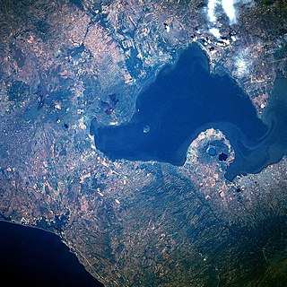
Lake Nicaragua or Cocibolca or Granada is a freshwater lake in Nicaragua. Of tectonic origin and with an area of 8,264 km2 (3,191 sq mi), it is the largest lake in Central America, the 19th largest lake in the world and the tenth largest in the Americas, slightly smaller than Lake Titicaca. With an elevation of 32.7 metres (107 ft) above sea level, the lake reaches a depth of 26 metres (85 ft). It is intermittently joined by the Tipitapa River to Lake Managua.
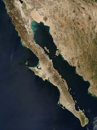
The Baja California peninsula is a peninsula in northwestern Mexico. It separates the Gulf of California from the Pacific Ocean. The peninsula extends from Mexicali, Baja California, in the north to Cabo San Lucas, Baja California Sur, in the south.

Jalapa is a city in Guatemala. It is the capital of the department of Jalapa; it is also the municipal seat of that department's municipality of Jalapa.

Sacatepéquez is one of the 22 departments of Guatemala. The name comes from Sacatepéquez, a city from November 21, 1542, until July 29, 1773, when it was destroyed by the 1773 Guatemalan Earthquake. Sacatepéquez means grasshill in the Nahuatl language. The capital of Sacatepéquez is Antigua Guatemala which is home to an extensive textile marketplace. Other important cities include Ciudad Vieja and San Lucas Sacatepéquez, which also hosts a marketplace and is a culinary attraction. The Chajoma were a group of indigenous people who were Kaqchikel speaking Indians identified Mixco Viejo as their capital, and spread throughout the Sacatepequez Department until their capital was moved to Ciudad Vieja, in Antigua.

Granada is a city in western Nicaragua and the capital of the Granada Department. With an estimated population of 105,862 (2022), it is Nicaragua's ninth most populous city. Granada is historically one of Nicaragua's most important cities, economically and politically. It has a rich colonial heritage, seen in its architecture and structure.
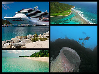
The Bay Islands is a group of islands off the coast of Honduras. Collectively, the islands form one of the 18 departments of Honduras. The departmental capital is Coxen Hole, on the island of Roatán.
Lake Managua, also known as Lake Xolotlán, is a lake in Nicaragua. At 1,042 km², it is approximately 65 kilometres (40 mi) long and 25 kilometres (16 mi) wide. Similarly to the name of Lake Nicaragua, its other name comes from the Nahuatl language, possibly from the Spanish Tlaxcalan and Mexica allies or the Nawat Nicarao that were already there in today Rivas Department. The city of Managua, the capital of Nicaragua, lies on its southwestern shore.

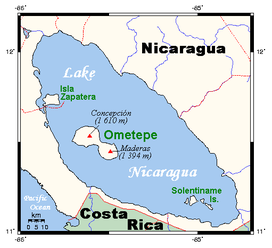
Ometepe is an island formed by two volcanoes rising out of Lake Nicaragua, located in the Rivas Department of the Republic of Nicaragua. Its name derives from the Nahuatl words ome (two) and tepetl (mountain), meaning "two mountains". It is the largest island in Lake Nicaragua.

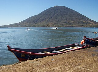
Concepción is one of two volcanoes that form the island of Ometepe, which is situated in Lake Nicaragua in Nicaragua, Central America.

Masaya is a caldera located in Masaya, Nicaragua, 20 km (12 mi) south of the capital Managua. It is Nicaragua's first and largest national park, and one of 78 protected areas of Nicaragua. The complex volcano is composed of a nested set of calderas and craters, the largest of which is Las Sierras shield volcano and caldera. Within this caldera lies a sub-vent, which is Masaya Volcano sensu stricto. The vent is a shield type composing of basaltic lavas and tephras and includes a summit crater. This hosts Masaya caldera, formed 2,500 years ago by an 8 km3 (1.9 cu mi) basaltic ignimbrite eruption. Inside this caldera a new basaltic complex has grown from eruptions mainly on a semi-circular set of vents that include the Masaya and Nindiri cones. The latter host the pit craters of Masaya, Santiago, Nindiri and San Pedro. Observations in the walls of the pit craters indicate that there have been several episodes of cone and pit crater formation.
El Tigre is an island located in the Gulf of Fonseca, a body of water on the Pacific coast of Central America. The island is a conical basaltic stratovolcano and the southernmost volcano in Honduras. It belongs to Valle department. Together with Isla Zacate Grande, Isla Comandante and a few tiny satellite islets and rocks, it forms the municipality of Amapala, with an area of 75.2 km2 (29.0 sq mi) and a population of 9,687 as of the census of 2001.

The Macuá is a cocktail made with white rum and fruit juices, usually lemon and guava juice. The Macuá is noted as the national drink of Nicaragua. The drink is named after pajaro macuá, a tropical bird native to the country.

Tourism in Nicaragua has grown considerably recently, and it is now the second largest industry in the nation. Nicaraguan President Daniel Ortega has stated his intention to use tourism to combat poverty throughout the country.
Zapatera is an archaeological site located on Isla Zapatera, a volcanic island in Lake Nicaragua, Granada Department, Nicaragua. The large quantity of statues, petroglyphs and pottery found at the site, and on other islands in the Zapatera archipelago, suggests the area was an important ceremonial centre of pre-Columbian Chorotega people between 800 and 1350 CE.
Ometepe Island is an important archaeological site, located in the Lake Nicaragua in the Republic of Nicaragua, administratively belongs to the Rivas Department. Its name derives from the Nahuatl words ome (two) and tepetl (mountain), meaning two mountains, given that it is formed and practically the whole island is formed by two volcanoes: Concepción and Maderas.
The Zapatera Archipelago is located in Lake Nicaragua, Nicaragua. It consists of the Zapatera Island, Isla el Muerto and several other islets. The Zapatera Archipelago National Park is located there.
Zapatera is a volcano in southern Nicaragua, which forms Zapatera Island in Lake Nicaragua.