The Zazhoginskoe field is one of the richest Russian field of shungite on the territory of the Republic of Karelia.
Contents

The Zazhoginskoe field is one of the richest Russian field of shungite on the territory of the Republic of Karelia.
The Zazhoginskoe field is one of the largest fields of shungite rocks in the world. [1] It is located on the outskirts of the village Tolvuya in Medvezhyegorsky District of Karelia, 1.7 km from the shore of Lake Onega, 5 km from a navigable bay. Shungite rocks were deposited around the northern part of Lake Onega and under the lake. The field consists of two: Zazhoginskoe and Maksovo. Developed areas of the field are located 2–3 km to the south of the village Tolvuya. The development of Zazhoginskoe field began in the early 1990s.
The field has a size of 22 km x 11 km. On the territory of the deposit are located the village Tolvuya and several other villages, including abandoned. Layers of shungite rocks interspersed with tuffs, dolomite and siltstone. Within the Zazhoginskoe field are sills and dikes of metadiabases and metagabbro. Thickness of the sills is typically less than 50 m, but at the upper base sills reach thicknesses of over 150 m. In general, igneous rocks make up about 30% of the productive series. Rocks of the upper base felt weak regional metamorphism (initial stage greenschist facies). A significant part of the deposits developed with metasomatic replacement of primary minerals by carbonate, sericite, albite and quartz. Currently 25 deposits have been identified and explored in varying degrees, containing from 0.2 to 58.0 million tons of high-carbon shungite rocks.
Rocks within the Zazhoginskoe field are sufficiently stable in composition. The sum (C+SiO2) is in the range of 83 - 90%.
Using the method of A. I. Nijinsky, the identified reserves are valued at around 1,241 million US dollars. [2] According to geologists, there are good prospects for discovery of new fields in the Kondopozhsky District, where the transport infrastructure is well-developed, in contrast to the district of Zaonezhye.
The only developer of Zazhoginskoe field is CDD Carbon-Shungite.
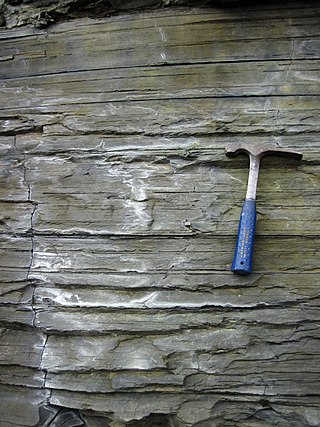
Shale is a fine-grained, clastic sedimentary rock formed from mud that is a mix of flakes of clay minerals (hydrous aluminium phyllosilicates, e.g. kaolin, Al2Si2O5(OH)4) and tiny fragments (silt-sized particles) of other minerals, especially quartz and calcite. Shale is characterized by its tendency to split into thin layers (laminae) less than one centimeter in thickness. This property is called fissility. Shale is the most common sedimentary rock.

Sedimentary rocks are types of rock that are formed by the accumulation or deposition of mineral or organic particles at Earth's surface, followed by cementation. Sedimentation is the collective name for processes that cause these particles to settle in place. The particles that form a sedimentary rock are called sediment, and may be composed of geological detritus (minerals) or biological detritus. The geological detritus originated from weathering and erosion of existing rocks, or from the solidification of molten lava blobs erupted by volcanoes. The geological detritus is transported to the place of deposition by water, wind, ice or mass movement, which are called agents of denudation. Biological detritus was formed by bodies and parts of dead aquatic organisms, as well as their fecal mass, suspended in water and slowly piling up on the floor of water bodies. Sedimentation may also occur as dissolved minerals precipitate from water solution.

The Republic of Karelia, Karjala or Karelia, is a republic of Russia situated in the northwest of the country. The republic is a part of the Northwestern Federal District, and covers an area of 172,400 square kilometres, with a population of 533,121 residents. Its capital is Petrozavodsk.

Petrozavodsk is the capital city of the Republic of Karelia, Russia, which stretches along the western shore of Lake Onega for some 27 kilometers (17 mi). The population of the city was 280,890 as of 2022.

Lake Onega is a lake in northwestern Russia, on the territory of the Republic of Karelia, Leningrad Oblast and Vologda Oblast. It belongs to the basin of the Baltic Sea, and is the second-largest lake in Europe after Lake Ladoga, slightly smaller than Lebanon. The lake is fed by about 50 rivers and is drained by the Svir.

Kondopoga is a town and the administrative center of Kondopozhsky District of the Republic of Karelia, Russia, located by the northern tip of the Kondopoga Bay of Lake Onega, near the mouth of the Suna River and Kivach Nature Reserve, about 54 kilometers (34 mi) from Petrozavodsk. Population: 32,987 (2010 Census); 34,863 (2002 Census); 36,365 (1989 Census).

Kizhi is an island near the geometrical center of Lake Onega in the Republic of Karelia, Russia. It is elongated from north to south and is about 6 kilometres (3.7 mi) long, 1 kilometre (0.62 mi) wide and is about 68 kilometres (42 mi) away from the capital of Karelia, Petrozavodsk.

The geology of the Australian Capital Territory includes rocks dating from the Ordovician around 480 million years ago, whilst most rocks are from the Silurian. During the Ordovician period the region—along with most of eastern Australia—was part of the ocean floor. The area contains the Pittman Formation consisting largely of Quartz-rich sandstone, siltstone and shale; the Adaminaby Beds and the Acton Shale.
Kambalda type komatiitic nickel ore deposits are a class of magmatic iron-nickel-copper-platinum-group element ore deposit in which the physical processes of komatiite volcanology serve to deposit, concentrate and enrich a Fe-Ni-Cu-(PGE) sulfide melt within the lava flow environment of an erupting komatiite volcano.

Uranium ore deposits are economically recoverable concentrations of uranium within the Earth's crust. Uranium is one of the most common elements in the Earth's crust, being 40 times more common than silver and 500 times more common than gold. It can be found almost everywhere in rock, soil, rivers, and oceans. The challenge for commercial uranium extraction is to find those areas where the concentrations are adequate to form an economically viable deposit. The primary use for uranium obtained from mining is in fuel for nuclear reactors.

The Temagami Greenstone Belt (TGB) is a small 2.7 billion year old greenstone belt in the Temagami region of Northeastern Ontario, Canada. It represents a feature of the Superior craton, an ancient and stable part of the Earth's lithosphere that forms the core of the North American continent and Canadian Shield. The belt is composed of metamorphosed volcanic rocks that range in composition from basalt to rhyolite. These form the east-northeast trend of the belt and are overlain by metamorphosed sedimentary rocks. They were created during several volcanic episodes involving a variety of eruptive styles ranging from passive lava eruptions to viscous explosive eruptions.

Vodlozersky National Park is a national park in the north of Russia, located in Onezhsky District of Arkhangelsk Oblast and Pudozhsky District in the Republic of Karelia. It was established April 20, 1991. Since 2001, the National Park has the status of a UNESCO Biosphere Reserve. The national park was created to protect coniferous forests (taiga) of Northern Russia.

The geology of Tasmania is complex, with the world's biggest exposure of diabase, or dolerite. The rock record contains representatives of each period of the Neoproterozoic, Paleozoic, Mesozoic and Cenozoic eras. It is one of the few southern hemisphere areas that were glaciated during the Pleistocene with glacial landforms in the higher parts. The west coast region hosts significant mineralisation and numerous active and historic mines.

Igneous rock, or magmatic rock, is one of the three main rock types, the others being sedimentary and metamorphic. Igneous rocks are formed through the cooling and solidification of magma or lava.

Onezhsky District is an administrative district (raion), one of the twenty-one in Arkhangelsk Oblast, Russia. As a municipal division, it is incorporated as Onezhsky Municipal District. It is located in the northwest of the oblast and borders with Primorsky District in the northeast, Plesetsky District in the southeast, Pudozhsky, Medvezhyegorsky, and Segezhsky Districts of the Republic of Karelia in the southwest, and with Belomorsky District of the Republic of Karelia in the west. In the north, the district is washed by the White Sea. The area of the district is 23,740 square kilometers (9,170 sq mi). Its administrative center is the town of Onega. Population: 14,017 (2010 Census); 16,791 (2002 Census); 22,269 (1989 Census).
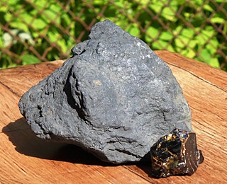
Shungite is a black and lustrous mineraloid that was first described from a deposit near Shunga village, in Karelia, Russia, from where it gets its name. Shungite can be low-carbon, medium-carbon and high-carbon percent by weight of carbon and the carbon base of shungite is a multilayered fullerene-like globule with a diameter of 10-30 nm. Shungite has been reported to contain trace amounts of fullerenes.
The Sable Tin Deposit also known as "Sobolinoye" is a high grade tin-copper deposit located in the Solnechny District of Khabarovsk Krai in the Russian Far East. Discovered in 1964 on the basis of 1:5000 – 1:10000 mapping which identified the presence of commercial concentrations of tin at surface. It is located within the Komsomolsk Ore (Tin) District, a major tin region within Russia with both historical and current mining activities. The deposit's resources were registered in 1987 and Technical Economic Conditions for design and construction were prepared by Gipronickel, a Norilsk subsidiary in 1993 but due to economic and political turbulence the deposit was never developed or exploited
The Azerbaijan is a country with very favorable natural conditions and rich natural resources. Snowy peaks, high mountains, foothill fertile soils, wide plains, Lowest Land Points Below Ocean Level are the main landscape forms of republic. This complex landscape structure has caused the variety in natural conditions - climate, soil-vegetation, and water resources. This, in turn, led to the uneven distribution of population and farms on the territory, and the specialization of production on different types.
The geology of Nunavut began to form nearly three billion years ago in the Archean and the territory preserves some of the world's oldest rock units.

Velikaya Guba is a village (selo) in the Medvezhyegorsky District, part of the Republic of Karelia, in turn a subject of the Russian Federation. It is located on Lake Onega, on the eastern bank of the Great Bay, about 110 km south of Medvezhyegorsk and some 80 east of Petrozavodsk. From here a very sparsely populated area comprising 2,895 square kilometers is administered. The entire territory has some 2,500 inhabitants.