
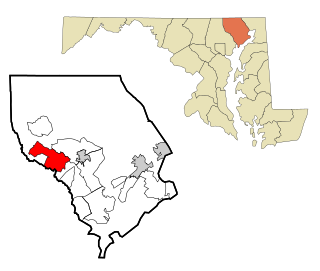
LaVale is a census-designated place (CDP) in Allegany County, Maryland, United States. It is part of the Cumberland, MD-WV Metropolitan Statistical Area. The population was 4,201 as of the 2020 census.
Fallston is a census-designated place (CDP) in Harford County, Maryland, United States. The population was 8,958 at the 2010 census, up from 8,427 in 2000. Fallston is a semi-rural community consisting mostly of farms and suburban-like developments.
Midlothian is an unincorporated community and census-designated place (CDP) in Allegany County, Maryland, United States; at one time it was called Midlothian Junction. As of the 2010 census it had a population of 320. Its ZIP code is 21543.

Mount Savage is an unincorporated community and census-designated place (CDP) in Allegany County, Maryland, United States. As of the 2010 census it had a population of 873.
Ellerslie is an unincorporated community and census-designated place (CDP) in Allegany County, Maryland, United States. As of the 2010 census it had a population of 572. Ellerslie is part of the Cumberland, MD-WV Metropolitan Statistical Area.
Eckhart Mines is an unincorporated community and census-designated place (CDP) in Allegany County, Maryland, United States. As of the 2010 census it had a population of 932.
Clarysville is an unincorporated community and census-designated place (CDP) in Allegany County, Maryland, United States. As of the 2010 census it had a population of 73.

Sabillasville is an unincorporated community and census-designated place in Frederick County, Maryland, United States. As of the 2010 census it had a population of 354.
Bier is an unincorporated community and census-designated place (CDP) in Allegany County, Maryland, United States. As of the 2010 census, it had a population of 173.
Carlos is an unincorporated community and census-designated place (CDP) in Allegany County, Maryland, United States. As of the 2010 census it had a population of 153.
Danville is an unincorporated community and census-designated place (CDP) in Allegany County, Maryland, United States. As of the 2010 census it had a population of 271.
Dawson is an unincorporated community and census-designated place (CDP) in Allegany County, Maryland, United States. As of the 2010 census it had a population of 103.
Detmold is an unincorporated community and census-designated place (CDP) in Allegany County, Maryland, United States. As of the 2010 census it had a population of 71.
Klondike is an unincorporated community and census-designated place (CDP) in Allegany County, Maryland, United States. As of the 2010 census it had a population of 118.
Moscow is an unincorporated community and census-designated place (CDP) in Allegany County, Maryland, United States. As of the 2010 census it had a population of 240.
Nikep is an unincorporated community and census-designated place (CDP) in Allegany County, Maryland, United States. As of the 2020 census it had a population of 95. Nikep is located in the Georges Creek Valley of western Allegany County, along the old route of Maryland Route 36. Lonaconing is 1.6 miles (2.6 km) to the northeast, and Westernport is 6.6 miles (10.6 km) to the southwest.

Franklin is an unincorporated community and census-designated place (CDP) in Allegany County, Maryland, United States. As of the 2010 census it had a population of 290.
Gilmore is an unincorporated community and census-designated place (CDP) in Allegany County, Maryland, United States. As of the 2010 census it had a population of 127. It is part of the Cumberland, MD-WV Metropolitan Statistical Area.
National is an unincorporated community and census-designated place (CDP) in Allegany County, Maryland, United States. As of the 2010 census it had a population of 56.
Ocean is an unincorporated community and census-designated place (CDP) in Allegany County, Maryland, United States. As of the 2010 census it had a population of 32.


