Bowling Green, Maryland

Last updated

Bowling Green, Maryland
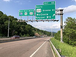
2019-05-17 17 02 48 View east along Interstate 68 and U.S. Route 40 (National Freeway) at Exit 42 (SOUTH U.S. Route 220-Greene Street, McCoole, Keyser WV) in Bowling Green, Allegany County, Maryland.jpg
I-68/US 40 in Bowling Green
USA Maryland location map.svg
Red pog.svg
Location within the State of Maryland
Usa edcp location map.svg
Red pog.svg
Bowling Green, Maryland (the United States)
Coordinates: 39°37′25″N78°48′22″W / 39.62361°N 78.80611°W / 39.62361; -78.80611
CountryFlag of the United States.svg United States
State Flag of Maryland.svg  Maryland
County Flag of Allegany County, Maryland.png Allegany
Area
[1]
  Total0.96 sq mi (2.50 km2)
  Land0.96 sq mi (2.50 km2)
  Water0.00 sq mi (0.00 km2)
Elevation
[2]
666 ft (203 m)
Population
 (2020)
  Total1,018
  Density1,056.02/sq mi (407.87/km2)
Time zone UTC−5 (Eastern (EST))
  Summer (DST) UTC−4 (EDT)
ZIP code
21502 [3]
Area code(s) 240 and 301
FIPS code 24-08850
GNIS feature ID2583587 [2]

Bowling Green is an unincorporated community and census-designated place (CDP) in Allegany County, Maryland, United States. As of the 2010 census it had a population of 1,077. [4]

Contents

It is located along U.S. Route 220 (McMullen Highway), directly southwest of the city of Cumberland and includes the former community of Roberts. The CDP of Potomac Park borders Bowling Green to the south, the Potomac River is to the east and Haystack Mountain is to the west. For many years, the community was mostly farmland but was later divided into building lots by the Buchanan, Roberts and Long families. CSX Transportation railroad tracks skirt the community along the river; in earlier years, a predecessor maintained the Roberts train station, which has since been closed.

The Upper Potomac Industrial Park is located in the northern part of the community, close to Cumberland.

Demographics

Historical population
CensusPop.Note
2010 1,077
2020 1,018−5.5%
U.S. Decennial Census [5]

Related Research Articles

<span class="mw-page-title-main">Ballenger Creek, Maryland</span> Census-designated place in Maryland

Ballenger Creek is an unincorporated community and census-designated place (CDP) in Frederick County, Maryland, United States. It is a part of the Frederick, Maryland urban area and is adjacent to Frederick's southern city limits. The CDP had a 2010 census population of 18,274.

<span class="mw-page-title-main">Darnestown, Maryland</span> Census-designated place in the United States

Darnestown is a United States census-designated place (CDP) and an unincorporated area in Montgomery County, Maryland. The CDP is 17.70 square miles (45.8 km2) with the Potomac River as its southern border and the Muddy Branch as much of its eastern border. Seneca Creek borders portions of its north and west sides. The Travilah, North Potomac, and Germantown census-designated places are adjacent to it, as is the city of Gaithersburg. Land area for the CDP is 16.39 square miles (42.4 km2). As of the 2020 census, the Darnestown CDP had a population of 6,723, while the village of Darnestown is considerably smaller in size and population. Downtown Washington, D.C. is about 22 miles (35 km) to the southeast.

<span class="mw-page-title-main">North Potomac, Maryland</span> Census-designated place named North Potomac in Maryland, United States

North Potomac is a census-designated place and unincorporated area in Montgomery County, Maryland, United States. It is located less than 5 miles (8.0 km) north of the Potomac River, and is about 20 miles (32 km) from Washington, D.C. It has a population of 23,790 as of 2020.

<span class="mw-page-title-main">Potomac, Maryland</span> Census-designated place in Maryland, United States

Potomac is an unincorporated community and census-designated place in Montgomery County, Maryland, United States. As of the 2020 census, it had a population of 47,018. It is named after the nearby Potomac River. A part of the Washington metropolitan area, many Potomac residents work in nearby Washington, D.C., and Northern Virginia.

<span class="mw-page-title-main">Travilah, Maryland</span> Census-designated place in Maryland

Travilah is a United States census-designated place and an unincorporated area in Montgomery County, Maryland. It is 17.28 square miles (44.8 km2) located along the north side of the Potomac River, and surrounded by the communities of Potomac, North Potomac, and Darnestown—all census-designated places. It had a population of 11,985 as of the 2020 census.

<span class="mw-page-title-main">Fort Washington, Maryland</span> Census-designated place in Maryland

Fort Washington is an unincorporated area and census-designated place in Prince George's County, Maryland, United States. It borders the Potomac River, situated 20 miles south of downtown Washington, D.C. As of the 2020 census, it had a population of 24,261. The Fort Washington community is located west of Maryland Route 210, with some additional area to the east of the highway.

<span class="mw-page-title-main">Great Falls, Virginia</span> Census-designated place in Virginia, United States

Great Falls is a census-designated place in Fairfax County, Virginia, United States. The population at the 2020 census was 15,953.

<span class="mw-page-title-main">Oxon Hill, Maryland</span> Census-designated place in Maryland, United States

Oxon Hill is an unincorporated area and census-designated place (CDP) in southern Prince George's County, Maryland, United States. Oxon Hill is a suburb of Washington, located southeast of the downtown district and east of Alexandria, Virginia. Since 2008, it contains the 300-acre (120 ha) National Harbor development on the shore of the Potomac River.

Cresaptown is an unincorporated community and census-designated place (CDP) located in Allegany County, Maryland, United States. As of the 2010 census it had a population of 6,247. Prior to 2010 it was part of the Cresaptown-Bel Air CDP. Cresaptown's post office was established December 22, 1800. Cresaptown is located 6 miles (10 km) southwest of Cumberland.

<span class="mw-page-title-main">Oldtown, Maryland</span> Census-designated place in Maryland, United States

Oldtown is an unincorporated community and census-designated place (CDP) in Allegany County, Maryland, United States, along the North Branch Potomac River. As of the 2010 census, it had a population of 86.

Potomac Park is an unincorporated subdivision and census-designated place (CDP) located on the North Branch Potomac River in Allegany County, Maryland, United States. As of the 2010 census, it had a population of 2,530. Potomac Park lies along U.S. Route 220 between Cresaptown and Cumberland. The CDP of Bowling Green is immediately to the north on Route 220.

<span class="mw-page-title-main">Mount Savage, Maryland</span> Census-designated place in Maryland, United States

Mount Savage is an unincorporated community and census-designated place (CDP) in Allegany County, Maryland, United States. As of the 2010 census it had a population of 873.

<span class="mw-page-title-main">Corriganville, Maryland</span> Census-designated place in Maryland, United States

Corriganville is an unincorporated community and census-designated place (CDP) in Allegany County, Maryland, United States. As of the 2010 census it had a population of 455. Corriganville is part of the Cumberland, MD-WV Metropolitan Statistical Area.

Ellerslie is an unincorporated community and census-designated place (CDP) in Allegany County, Maryland, United States. As of the 2010 census it had a population of 572. Ellerslie is part of the Cumberland, MD-WV Metropolitan Statistical Area.

<span class="mw-page-title-main">Flintstone, Maryland</span> Census-designated place in Maryland, United States

Flintstone is an unincorporated community and census-designated place (CDP) in Allegany County, Maryland, United States. As of the 2010 census it had a population of 177. It is part of the Cumberland, MD-WV Metropolitan Statistical Area.

<span class="mw-page-title-main">Spring Gap, Maryland</span> Census-designated place in Maryland, United States

Spring Gap is an unincorporated community and census-designated place (CDP) in Allegany County, Maryland, United States. As of the 2010 census it had a population of 55.

Clarysville is an unincorporated community and census-designated place (CDP) in Allegany County, Maryland, United States. As of the 2010 census it had a population of 73.

Dawson is an unincorporated community and census-designated place (CDP) in Allegany County, Maryland, United States. As of the 2010 census it had a population of 103.

Lowes Island is a census-designated place (CDP) in Loudoun County, Virginia, United States. The population as of the 2010 United States Census was 10,756. Along with nearby Countryside and Cascades, it is considered one of the three main components of the Potomac Falls community.

Gilmore is an unincorporated community and census-designated place (CDP) in Allegany County, Maryland, United States. As of the 2010 census it had a population of 127. It is part of the Cumberland, MD-WV Metropolitan Statistical Area.

References

  1. "2020 U.S. Gazetteer Files". United States Census Bureau. Retrieved April 26, 2022.
  2. 1 2 U.S. Geological Survey Geographic Names Information System: Bowling Green, Maryland
  3. "Bowling Green MD ZIP Code". zipdatamaps.com. 2023. Retrieved February 17, 2023.
  4. "Geographic Identifiers: 2010 Demographic Profile Data (G001): Bowling Green CDP, Maryland". U.S. Census Bureau, American Factfinder. Archived from the original on February 12, 2020. Retrieved May 23, 2013.
  5. "Census of Population and Housing". Census.gov. Retrieved June 4, 2016.