"},"tourist":{"wt":"[[File:MUTCD D6-4.svg|20px|alt=|link=]] [[Historic National Road]]
[[File:MD scenic byway.svg|20px|alt=|link=]] [[Mountain Maryland Scenic Byway]]"},"established":{"wt":"1927"},"direction_a":{"wt":"South"},"terminus_a":{"wt":"{{jct|state=WV|WV|46}}at [[Westernport,Maryland|Westernport]]"},"junction":{"wt":"{{plainlist|\n*{{jct|state=MD|MD|135}}at Westernport\n*{{jct|state=MD|I|68|US|40}}near [[Frostburg,Maryland|Frostburg]]\n*{{jct|state=MD|US-Alt|40|dab1=Cumberland}}at Frostburg\n}}"},"direction_b":{"wt":"North"},"terminus_b":{"wt":"{{plainlist|*{{jct|state=MD|US-Alt|40|dab1=Cumberland}}at [[Cumberland,Maryland|Cumberland]]}}"},"counties":{"wt":"[[Allegany County,Maryland|Allegany]]"},"previous_type":{"wt":"MD"},"previous_route":{"wt":"35"},"next_type":{"wt":"MD"},"next_route":{"wt":"38"}},"i":0}}]}" id="mwBA">.mw-parser-output .header-default,.mw-parser-output .header-UNK,.mw-parser-output .header-ATA,.mw-parser-output .header-BDI,.mw-parser-output .header-CAF,.mw-parser-output .header-COG,.mw-parser-output .header-COM,.mw-parser-output .header-DMA,.mw-parser-output .header-ERI,.mw-parser-output .header-FSM,.mw-parser-output .header-GAB,.mw-parser-output .header-HTI,.mw-parser-output .header-GMB,.mw-parser-output .header-GUY,.mw-parser-output .header-HRV,.mw-parser-output .header-KEN,.mw-parser-output .header-KNA,.mw-parser-output .header-LBY,.mw-parser-output .header-LCA,.mw-parser-output .header-MHL,.mw-parser-output .header-MRT,.mw-parser-output .header-NER,.mw-parser-output .header-NIU,.mw-parser-output .header-NRU,.mw-parser-output .header-SDN,.mw-parser-output .header-SLB,.mw-parser-output .header-SOM,.mw-parser-output .header-SSD,.mw-parser-output .header-TGO,.mw-parser-output .header-TUV,.mw-parser-output .header-UGA,.mw-parser-output .header-VCT{background:#cedff2}.mw-parser-output .header-deleted{background:#ccc}.mw-parser-output .header-hist{background:#704214;color:#fff}.mw-parser-output .header-deleted-hist{background:#ddcba4}.mw-parser-output .header-uc{background:#ffa500}.mw-parser-output .header-autobahn{background:#2C5BB7;color:#fff}.mw-parser-output .header-ASIA{background:#1e2c76;color:#fff}.mw-parser-output .header-ASIA-RUS{background:#00004e;color:#fff}.mw-parser-output .header-EUR{background:#08842C;color:#fff}.mw-parser-output .header-EUR-ESP{background:#13926c;color:#fff}.mw-parser-output .header-EUR-FIN{background:#00997c;color:#fff}.mw-parser-output .header-EUR-FRA{background:#28961e;color:#fff}.mw-parser-output .header-EUR-NOR{background:#00965e;color:#fff}.mw-parser-output .header-EUR-RUS{background:#00a500;color:#fff}.mw-parser-output .header-EUR-UKR{background:#090;color:#fff}.mw-parser-output .header-minor,.mw-parser-output .header-AND,.mw-parser-output .header-AUT,.mw-parser-output .header-BFA,.mw-parser-output .header-CMR,.mw-parser-output .header-CPV,.mw-parser-output .header-DEU,.mw-parser-output .header-DJI,.mw-parser-output .header-DZA,.mw-parser-output .header-ENG,.mw-parser-output .header-FRA,.mw-parser-output .header-FIN,.mw-parser-output .header-GEO,.mw-parser-output .header-GGY,.mw-parser-output .header-GIB,.mw-parser-output .header-GBR,.mw-parser-output .header-GNB,.mw-parser-output .header-GNQ,.mw-parser-output .header-GUF,.mw-parser-output .header-IMN,.mw-parser-output .header-IRL,.mw-parser-output .header-IRN,.mw-parser-output .header-JEY,.mw-parser-output .header-MAR,.mw-parser-output .header-MCO,.mw-parser-output .header-MDV,.mw-parser-output .header-MLI,.mw-parser-output .header-MTQ,.mw-parser-output .header-MYT,.mw-parser-output .header-NIR,.mw-parser-output .header-NPL,.mw-parser-output .header-PRT,.mw-parser-output .header-PSE,.mw-parser-output .header-REU,.mw-parser-output .header-SCT,.mw-parser-output .header-SEN,.mw-parser-output .header-STP,.mw-parser-output .header-TCD,.mw-parser-output .header-TZA,.mw-parser-output .header-WLS{background:#fff;border:2px solid #000}.mw-parser-output .header-motorway,.mw-parser-output .header-ALA,.mw-parser-output .header-AZE,.mw-parser-output .header-CHE,.mw-parser-output .header-EST,.mw-parser-output .header-GIN,.mw-parser-output .header-GRC,.mw-parser-output .header-JOR,.mw-parser-output .header-LAO,.mw-parser-output .header-LBN,.mw-parser-output .header-LIE,.mw-parser-output .header-MLT,.mw-parser-output .header-MNG,.mw-parser-output .header-MYS,.mw-parser-output .header-NLD,.mw-parser-output .header-OMN,.mw-parser-output .header-ROU,.mw-parser-output .header-SUR,.mw-parser-output .header-SVK,.mw-parser-output .header-SYR,.mw-parser-output .header-TTO,.mw-parser-output .header-YEM{background:#0079C1;color:#fff}.mw-parser-output .header-MUTCDblue,.mw-parser-output .header-AFG,.mw-parser-output .header-BGR,.mw-parser-output .header-CZE,.mw-parser-output .header-CYP,.mw-parser-output .header-EGY,.mw-parser-output .header-ITA,.mw-parser-output .header-PAK,.mw-parser-output .header-SMR,.mw-parser-output .header-SVK,.mw-parser-output .header-SWE{background:#003f87;color:#fff}.mw-parser-output .header-MUTCDgreen,.mw-parser-output .header-ANG,.mw-parser-output .header-ARE,.mw-parser-output .header-ARG,.mw-parser-output .header-BEL,.mw-parser-output .header-BHN,.mw-parser-output .header-BEN,.mw-parser-output .header-BLZ,.mw-parser-output .header-BOL,.mw-parser-output .header-BRA,.mw-parser-output .header-BRN,.mw-parser-output .header-BWA,.mw-parser-output .header-CAN,.mw-parser-output .header-CHL,.mw-parser-output .header-CHN,.mw-parser-output .header-COL,.mw-parser-output .header-CRI,.mw-parser-output .header-CRI,.mw-parser-output .header-CUB,.mw-parser-output .header-DOM,.mw-parser-output .header-ECU,.mw-parser-output .header-ETH,.mw-parser-output .header-FJI,.mw-parser-output .header-GHA,.mw-parser-output .header-GRD,.mw-parser-output .header-GTM,.mw-parser-output .header-HKG,.mw-parser-output .header-HND,.mw-parser-output .header-HUN,.mw-parser-output .header-IDN,.mw-parser-output .header-IRQ,.mw-parser-output .header-KIR,.mw-parser-output .header-KHM,.mw-parser-output .header-KOR,.mw-parser-output .header-KWT,.mw-parser-output .header-LBR,.mw-parser-output .header-LKA,.mw-parser-output .header-LSO,.mw-parser-output .header-MEX,.mw-parser-output .header-MMR,.mw-parser-output .header-MOZ,.mw-parser-output .header-MUS,.mw-parser-output .header-NAM,.mw-parser-output .header-NGA,.mw-parser-output .header-NIC,.mw-parser-output .header-NZL,.mw-parser-output .header-PAN,.mw-parser-output .header-PER,.mw-parser-output .header-PLW,.mw-parser-output .header-PNG,.mw-parser-output .header-POL,.mw-parser-output .header-PRI,.mw-parser-output .header-PRK,.mw-parser-output .header-PRY,.mw-parser-output .header-QAT,.mw-parser-output .header-RWA,.mw-parser-output .header-SAU,.mw-parser-output .header-SGP,.mw-parser-output .header-SLV,.mw-parser-output .header-SWZ,.mw-parser-output .header-TAH,.mw-parser-output .header-THA,.mw-parser-output .header-TLS,.mw-parser-output .header-TON,.mw-parser-output .header-TUN,.mw-parser-output .header-TUR,.mw-parser-output .header-TWN,.mw-parser-output .header-URY,.mw-parser-output .header-VEN,.mw-parser-output .header-VNM,.mw-parser-output .header-USA,.mw-parser-output .header-WSM,.mw-parser-output .header-ZAF,.mw-parser-output .header-ZMB,.mw-parser-output .header-ZWE{background:#006a4d;color:#fff}.mw-parser-output .header-primary,.mw-parser-output .header-BRB,.mw-parser-output .header-JAM{background:#00703c;color:#ffd200}.mw-parser-output .header-primary-white,.mw-parser-output .header-BGD,.mw-parser-output .header-BTN,.mw-parser-output .header-MWI{background:#00703c;color:#fff}.mw-parser-output .header-SUN,.mw-parser-output .header-ARM,.mw-parser-output .header-AZE,.mw-parser-output .header-BLR,.mw-parser-output .header-KAZ,.mw-parser-output .header-KGZ,.mw-parser-output .header-LVA,.mw-parser-output .header-LTU,.mw-parser-output .header-MDA,.mw-parser-output .header-RUS,.mw-parser-output .header-TJK,.mw-parser-output .header-TKM,.mw-parser-output .header-UKR,.mw-parser-output .header-UZB{background:#0d69e1;color:#fff}.mw-parser-output .header-blue-var1{background:#06c;color:#fff}.mw-parser-output .header-blue-var2{background:#276fb7;color:#fff}.mw-parser-output .header-dark-blue,.mw-parser-output .header-DNK,.mw-parser-output .header-VNM{background:#039;color:#fff}.mw-parser-output .header-yellow{background:#fc3;border:1px solid #000}.mw-parser-output .header-ALB{background:#00408b;color:#fff}.mw-parser-output .header-AUS{background:#336745;color:#ffa709}.mw-parser-output .header-AUS-freeway{background:#d2e2f9}.mw-parser-output .header-AUS-highway{background:#e9f9d2}.mw-parser-output .header-AUS-road{background:#ffffe0}.mw-parser-output .header-AUS-street{background:#f9e2d2}.mw-parser-output .header-AUS-track{background:#fee8ab}.mw-parser-output .header-BEL,.mw-parser-output .header-COD{background:#005b8c;color:#fff}.mw-parser-output .header-BIH{background:#0b8f4b;color:#fff}.mw-parser-output .header-CYP-A{background:#005024;color:#ffc000}.mw-parser-output .header-DEU-B,.mw-parser-output .header-LUX,.mw-parser-output .header-MKD,.mw-parser-output .header-MNE,.mw-parser-output .header-SRB,.mw-parser-output .header-SVN,.mw-parser-output .header-YUG{background:#fc3}.mw-parser-output .header-DEU-scenic{background:#633a34;color:#fff}.mw-parser-output .header-DNK-red{background:#fff;color:#af1e2d;border:2px solid #af1e2d}.mw-parser-output .header-ESP{background:#e8e8e8}.mw-parser-output .header-ESP-A,.mw-parser-output .header-ESP-AP{background:#19408b;color:#fff}.mw-parser-output .header-ESP-N{background:#bf0411;color:#fff}.mw-parser-output .header-FIN-blue{background:#005eb8;color:#fff}.mw-parser-output .header-FIN-green{background:#00997c;color:#fff}.mw-parser-output .header-IND{background:#128807;color:#fff}.mw-parser-output .header-ISL{background:#ffd200;border:2px solid #000}.mw-parser-output .header-ISR{background:#007e00;color:#fff}.mw-parser-output .header-ISR-freeway{background:#0000fe;color:#fff}.mw-parser-output .header-JPN{background:#0066b3;color:#fff}.mw-parser-output .header-JPN-Exp{background:#005d35;color:#fff}.mw-parser-output .header-KOS{background:#06c;color:#fff}.mw-parser-output .header-KOS-R,.mw-parser-output .header-PHL{background:#093;color:#fff}.mw-parser-output .header-MDG{background:#fff;color:#af1e2d;border:2px solid #000}.mw-parser-output .header-NOR{background:#f2a900}
MD 36 highlighted in red | ||||
Route information | ||||
Maintained by MDSHA | ||||
Length | 29.43 mi [1] (47.36 km) | |||
Existed | 1927–present | |||
Tourist routes | ![]() ![]() | |||
Major junctions | ||||
South end | ![]() | |||
| ||||
North end | ||||
Location | ||||
Country | United States | |||
State | Maryland | |||
Counties | Allegany | |||
Highway system | ||||
|
Maryland Route 36 (also known as MD 36 or Route 36) is a 29.43-mile (47.36 km) state highway located in Allegany County, Maryland, United States. MD 36's southern terminus is at the West Virginia Route 46 (WV 46) bridge in Westernport and its northern terminus at U.S. Route 40 Alternate (US 40 Alt.) near Cumberland. Between Westernport and Frostburg, it is known as Georges Creek Road, and from Frostburg to Cumberland it is known as Mount Savage Road. Like the majority of Maryland state highways, MD 36 is maintained by the Maryland State Highway Administration (MDSHA).
MD 36 serves as the main road through the Georges Creek Valley, a region which is historically known for coal mining, and has been designated by MDSHA as part of the Coal Heritage Scenic Byway. [2] MD 36 is the main road connecting the towns of Westernport, Lonaconing, and Midland in southwestern Allegany County, as well as Frostburg, Mount Savage, and Corriganville in northwestern Allegany County.
MD 36 has two main sections: Georges Creek Road, which runs along the Georges Creek Valley, from Westernport to Frostburg in southwestern Allegany County, and Mount Savage Road, which runs eastward from Frostburg to Cumberland in northwestern Allegany County. MD 36 is a part of the National Highway System as a principal arterial from Interstate 68 (I-68) to US 40 Alt. in Frostburg and from MD 35 at Corriganville to US 40 Alt. in Cumberland. [1] [3]
MD 36 begins at the WV 46 bridge in Westernport, crossing MD 135 in Westernport, and runs northeast across western Allegany County as a two-lane undivided road named Georges Creek Road, named for Georges Creek, a North Branch Potomac River tributary which the road parallels. The roadway also parallels the Georges Creek Railway. [1] A short distance outside Westernport city limits, MD 36 intersects MD 937, an old alignment of MD 36. Near Barton, MD 36 intersects MD 935, which is the old alignment of MD 36 through Barton. MD 36 bypasses Barton, climbing the hillside above the Georges Creek Valley before descending back into the valley as it approaches Lonaconing. MD 935 returns to MD 36 south of Lonaconing, with its northern terminus at MD 36. [1]
As the road enters Lonaconing, it narrows and passes through the town as Main Street, intersecting Douglas Avenue near the center of Lonaconing. [1] Along Main Street in Lonaconing is the Lonaconing Iron Furnace, a historic blast furnace which operated in the early 19th century. [4]
MD 36 then continues toward Midland. At Midland, there is a sharp curve in the road. [1] Along this curve, MD 36 intersects Church Street, which connects to MD 936, the old alignment of MD 36 between Midland and Frostburg. The new alignment of MD 36 proceeds northeast, passing near Vale Summit, where it intersects MD 55. [1]
North of the MD 55 intersection, MD 36 passes west of a park and ride lot before it meets I-68/US 40 at a diamond interchange at exit 34. [1] Near this interchange is God's Ark of Safety, a church famous for its attempt to build a replica of Noah's Ark. [5] Between Midland and Frostburg, there is a short section near the I-68/US 40 interchange where MD 36 expands to four lanes. Upon entering Frostburg, MD 36 joins US 40 Alt. as Main Street. MD 36 follows Main Street westward through Frostburg, meeting the northern terminus of MD 936 at Grant Street. At Depot Street, near the center of Frostburg, MD 36 connects to the western depot of the Western Maryland Scenic Railroad. At the intersection with Water Street, MD 36 leaves US 40 Alt., and upon leaving Frostburg city limits its name changes to Mount Savage Road. [1]
After leaving Frostburg, MD 36 is known as Mount Savage Road, as it travels eastward, perpendicular to its signed direction, toward Mount Savage. North of Eckhart Mines, MD 36 meets MD 638, which connects MD 36 to US 40 Alt. in Eckhart Mines. [1] The road between Frostburg and Mount Savage is particularly curvy, and includes several hairpin turns near Frostburg. [1]
As the road enters Mount Savage, it passes by the Mount Savage Castle, a Scottish-style castle built in 1840, which currently operates as a bed-and-breakfast. In Mount Savage, the route narrows as it follows Main Street. [1] East of Mount Savage, the route widens. [1]
In Barrelville, MD 36 intersects MD 47, which connects it with PA 160 in Somerset County. [1] From its intersection with MD 47 to its terminus at Cumberland, MD 36 follows newer alignments, with the old alignments being designated MD 831. At Corriganville, MD 36 intersects MD 35, which connects it with PA 96 in Bedford County. [1] MD 36 ends at US 40 Alt. at the Narrows near Cumberland. [1]
MD 36 passes through the Georges Creek Valley, which has a long history of coal mining. In recognition of this, the MDSHA has designated MD 36 as part of the Coal Heritage Scenic Byway. [2] Coal mining was a major industry in western Maryland in the 19th century, with railroads being the major route connecting the coal mines to markets outside the Georges Creek Valley. [6] Deep mining, which was the primary mining method used in western Maryland, declined in use after World War II, replaced primarily by surface mining. [7] Although Maryland coal production is now only a small fraction of total U.S. coal production, [7] coal from the Georges Creek Valley is used to power the AES Warrior Run power plant in Cumberland. [8]
MD 36 was assigned a route number before 1927, earlier than most of the other Maryland state highways. [9] [10] The original alignment of MD 36 in southern Allegany County closely paralleled the Georges Creek Railroad. Later realignments have shifted MD 36 away from the railroad in several locations, but three crossings remain: one north of Lonaconing, one south of Lonaconing near the MD 935 intersection, [11] and a third crossing near Westernport. [12]
Over the years, multiple new alignments of MD 36 have been built for various reasons, such as to smooth out curves in the road. Several of the old alignments have been assigned route numbers of their own. The southernmost of these is MD 937, which consists of the old alignment through Westernport. Prior to the construction of the bridge connecting MD 36 to WV 46, MD 937 was the alignment of MD 36 through Westernport, ending at MD 135. In Barton, MD 935 carries the old alignment of MD 36. The longest of the old alignment sections is MD 936, which runs from Midland to Frostburg, and was bypassed in the 1970s with a new alignment of MD 36 following part of MD 55 and connecting to Interstate 68 (I-68). Prior to this change, MD 55 ended in Midland; [13] it has since been truncated to its current terminus at Vale Summit. [14]
North of Frostburg, several old alignments are designated as MD 831, though these segments of road are not signed. Among these segments of road are Kriegbaum Road (designated as MD 831C), and Old Mount Savage Road (designated as MD 831A). Kriegbaum Road splits from MD 36 west of Corriganville and runs through Corriganville, returning to MD 36 east of the town. Old Mount Savage Road intersects MD 36 west of the Cumberland Narrows, and runs southward to intersect US 40 Alt. near its current intersection with MD 36. [1]
The entire route is in Allegany County.
Location | mi [1] | km | Destinations | Notes | |
---|---|---|---|---|---|
Westernport | 0.00 | 0.00 | ![]() ![]() | West Virginia state line at North Branch Potomac River; southern terminus | |
0.06 | 0.097 | ![]() | |||
1.44 | 2.32 | ![]() ![]() | Northern terminus of MD 937; former alignment of MD 36 | ||
Barton | 4.07 | 6.55 | ![]() ![]() | Southern terminus of MD 935; former alignment of MD 36 | |
Lonaconing | 6.85 | 11.02 | ![]() ![]() | Northern terminus of MD 935 | |
8.03 | 12.92 | Douglas Avenue north | Former MD 657 | ||
Midland | 11.06 | 17.80 | ![]() ![]() | Southern terminus of MD 936; former alignment of MD 36 | |
Vale Summit | 14.04 | 22.60 | ![]() ![]() | Southern terminus of MD 55 | |
Frostburg | 15.05 | 24.22 | ![]() ![]() | Exit 34 on I-68 | |
16.44 | 26.46 | ![]() ![]() | Western terminus of MD 743 | ||
16.53 | 26.60 | ![]() ![]() ![]() | South end of US 40 Alt. overlap | ||
17.07 | 27.47 | ![]() ![]() | Northern terminus of MD 936 | ||
17.60 | 28.32 | ![]() ![]() ![]() | North end of US 40 Alt. overlap | ||
Zihlman | 20.36 | 32.77 | ![]() ![]() | Northern terminus of MD 638 | |
Barrelville | 24.34 | 39.17 | ![]() ![]() | Southern terminus of MD 47; connects MD 36 to PA 160 | |
Corriganville | 26.64 | 42.87 | ![]() ![]() | Western terminus of MD 831; officially MD 831C; former alignment of MD 36 | |
27.34 | 44.00 | ![]() ![]() | Southern terminus of MD 35; connects MD 36 to PA 96 | ||
27.51 | 44.27 | ![]() ![]() | Eastern terminus of MD 831; officially MD 831C | ||
Cumberland | 29.05 | 46.75 | ![]() ![]() | Northern terminus of MD 831; officially MD 831A; former alignment of MD 36 | |
29.43 | 47.36 | ![]() ![]() | Northern terminus | ||
1.000 mi = 1.609 km; 1.000 km = 0.621 mi
|
Allegany County is located in the northwestern part of the U.S. state of Maryland. As of the 2020 census, the population was 68,106. Its county seat is Cumberland. The name Allegany may come from a local Lenape word, welhik hane or oolikhanna, which means 'best flowing river of the hills' or 'beautiful stream'. A number of counties and a river in the Appalachian region of the U.S. are named Allegany, Allegheny, or Alleghany. Allegany County is part of the Cumberland, MD-WV Metropolitan Statistical Area. It is a part of the Western Maryland "panhandle".
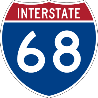
Interstate 68 (I-68) is a 112.9-mile (181.7 km) Interstate Highway in the US states of West Virginia and Maryland, connecting I-79 in Morgantown, West Virginia, to I-70 in Hancock, Maryland. I-68 is also Corridor E of the Appalachian Development Highway System. From 1965 until the freeway's construction was completed in 1991, it was designated as U.S. Route 48 (US 48). In Maryland, the highway is known as the National Freeway, an homage to the historic National Road, which I-68 parallels between Keysers Ridge and Hancock. The freeway mainly spans rural areas and crosses numerous mountain ridges along its route. A road cut at Sideling Hill exposed geological features of the mountain and has become a tourist attraction.
Barton is a town in Allegany County, Maryland, United States, located along the Georges Creek Valley. It is part of the Cumberland, MD-WV Metropolitan Statistical Area. The population was 457 at the 2010 census.
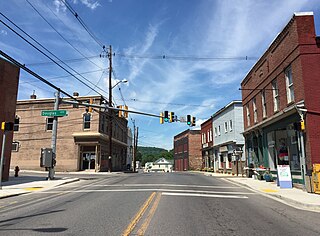
Lonaconing is a town in Allegany County, Maryland, United States, located along the Georges Creek Valley. It is part of the Cumberland, MD-WV Metropolitan Statistical Area. The population was 1,214 at the 2010 census.
Midland is a town in Allegany County, Maryland, United States, along the Georges Creek Valley. It is part of the Cumberland, MD-WV Metropolitan Statistical Area. The population was 446 at the 2010 census. Midland was founded in 1850 as a coal-mining community, though today only some strip mining remains.
Westernport, also known as Piedmont is a town in Allegany County, Maryland, United States, along the Georges Creek Valley. It is part of the Cumberland, MD-WV Metropolitan Statistical Area. The population was 1,888 at the 2010 census.
Georges Creek is a 17.6-mile-long (28.3 km) tributary stream of the North Branch Potomac River in western Maryland. The creek has its headwaters on Savage Mountain near Frostburg and empties into the North Branch Potomac River at Westernport, all in western Allegany County. Along the Georges Creek Valley, there exists a series of small towns founded in the nineteenth century for miners' homes. The Georges Creek Valley is rich in wide veins of coal, once extracted by deep mines but still mined today through surface mining.
Georges Creek Valley is located in Allegany County, Maryland along the Georges Creek. The valley is rich in wide veins of coal, known historically as "The Big Vein." Coal was once extracted by deep mines but is only mined today through surface mining. The Georges Creek Valley was once a major center for the US coal industry.
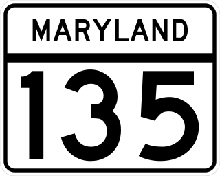
Maryland Route 135 is a state highway in the U.S. state of Maryland. Known for most of its length as Maryland Highway, the state highway runs 29.00 miles (46.67 km) from U.S. Route 219 in Oakland in Garrett County east to US 220 in McCoole in Allegany County. MD 135 is the main link between the towns of Oakland, Mountain Lake Park, Loch Lynn Heights, and Deer Park on the Appalachian Plateau and the communities of Bloomington, Luke, Westernport, and McCoole in the upper valley of the North Branch Potomac River. These groups of towns are separated by Backbone Mountain.
Cumberland, MD-WV MSA, or Cumberland Metro for short, is the Metropolitan Statistical Area of Cumberland, Maryland and the surrounding economic region of Allegany County, Maryland and Mineral County, West Virginia, in the United States.
The Georges Creek Railroad was a railroad operated by the Georges Creek Coal and Iron Company in Western Maryland. The railroad operated from 1853 to 1863, when it was acquired by the Cumberland and Pennsylvania Railroad (C&P).
Mountain Ridge High School is a high school in Frostburg, Maryland, United States, that houses over 1000 students from the Georges Creek Valley, the Greater Frostburg vicinity, and the Westernport region. Mountain Ridge is part of Allegany County Public Schools. The school mascot is a miner and the school colors are red, black, white and gold.
Maryland Route 35 is a state highway in the U.S. state of Maryland. Known as Ellerslie Road, the state highway runs 2.37 miles (3.81 km) north from MD 36 in Corriganville to the Pennsylvania state line in Ellerslie. There the highway continues north as Pennsylvania Route 96.
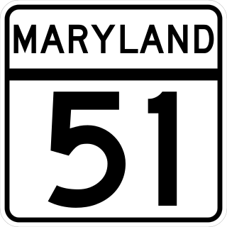
Maryland Route 51 is a state highway in the U.S. state of Maryland. Known for most of its length as Oldtown Road, the state highway runs 25.53 miles (41.09 km) from an interchange with Interstate 68 (I-68) in Cumberland south to the West Virginia state line at the Potomac River, where the highway continues east as West Virginia Route 9 toward Paw Paw. Around Cumberland, MD 51 is a major highway that provides a bypass of the South End neighborhood of that city and access to industrial areas along the North Branch Potomac River. South of North Branch, MD 51 is a rural highway connecting small communities along the river in southeastern Allegany County, including Oldtown. Documentation from the Maryland State Highway Administration depict the highway as following an east-west alignment, but all signage indicates a north-south road.
Maryland Route 55 (MD 55) is a state highway in the U.S. state of Maryland. Known as Vale Summit Road, the state highway runs 2.53 miles (4.07 km) from MD 36 in Vale Summit north to U.S. Route 40 Alternate in Clarysville. MD 55 connects the La Vale area with Midland in the upper Georges Creek Valley in northwestern Allegany County. MD 55 was paved from Clarysville to Vale Summit around 1921 and extended south to Midland in the late 1930s. The southern terminus of the state highway was truncated at Vale Summit when MD 36 took over part of the highway for a new alignment in the early 1970s.
Maryland Route 936 is a state highway in the U.S. state of Maryland. Known for most of its length as Upper Georges Creek Road, the state highway runs 5.04 miles (8.11 km) from Church Street in Midland north to U.S. Route 40 Alternate and MD 36 in Frostburg. MD 936 is the old alignment of MD 36 between Midland and Frostburg in the upper Georges Creek Valley of western Allegany County. The state highway was designated when MD 36 moved to a new alignment between the two communities in the early 1970s.
Maryland Route 937 is an unsigned state highway in the U.S. state of Maryland. The state highway runs 1.53 miles (2.46 km) from MD 135 north to MD 36 within Westernport. MD 937 is the old alignment of MD 36 through Westernport in the Georges Creek Valley of western Allegany County. The state highway was designated when MD 36 moved to a new alignment through the community in the early 1980s.
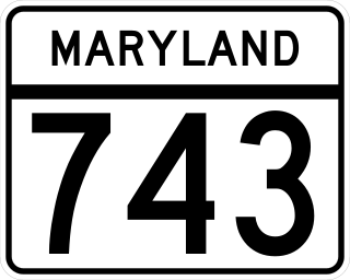
Maryland Route 743 (MD 743) is a state highway in the U.S. state of Maryland. The state highway runs 1.00 mile (1.61 km) from MD 36 in Frostburg east to U.S. Route 40 Alternate (US 40 Alternate) in Eckhart Mines. MD 743 is the original alignment of US 40 through Eckhart Mines. The state highway was designated when US 40 bypassed Eckhart Mines around 1950.
Allegany County Public Schools is a public school district serving Allegany County, Maryland, United States.
U.S. Route 40 Alternate is the U.S. Highway designation for a former segment of U.S. Route 40 (US 40) through Garrett and Allegany counties in Maryland. The highway begins at US 40 near exit 14 on Interstate 68 (I-68) and runs 31.80 miles (51.18 km) eastward to Cumberland, where it ends at exit 44 on I-68. Alt US 40 is maintained by the Maryland State Highway Administration (MDSHA).
Route map: