
The Rätikon is a mountain range of the Central Eastern Alps, located at the border between Vorarlberg, Liechtenstein and Graubünden. It is the geological border between the Eastern and Western Alps and stretches from the Montafon as far as the Rhine. In the south, the Prättigau is its limit, and in the north, it is the Walgau. In the east, it borders the Silvretta groups. The Rätikon mountain range derives its name from Raetia, a province of the Roman Empire, named after the Rhaetian people.

Drei Schwestern is a mountain located on the border of Austria and Liechtenstein. It forms a natural boundary between Liechtenstein and the Austrian state of Vorarlberg.

Wildspitze is the highest mountain in the Ötztal Alps and in North Tyrol, as well as the second highest mountain in Austria after the Großglockner and in terms of prominence is the fourth summit of the Alps and the fifteenth of Europe.

The Aiguille de Bionnassay is a mountain in the Mont Blanc massif of the Alps in France and Italy. It has been described as "one of the most attractive satellite peaks of Mont Blanc", and is located on its western side. The mountain's south and east ridges form the frontier between the two countries, and its summit is a knife-edge crest of snow and ice. Reaching it via any route provides a "splendid and serious snow and ice climb".

The Grünhorn is a mountain in the Bernese Alps range of the Swiss Alps. It is located on the ridge between the two largest glaciers of the Alps: the Aletsch Glacier to the west and the Fiescher Glacier to the east. To the south lies the Gross Wannenhorn and, to the north, the Gross Fiescherhorn.

The Grauspitz is a mountain in the Rätikon range of the Alps, located on the border between Liechtenstein and Switzerland. With an elevation of 2,599 metres above sea level, the Grauspitz is the highest mountain in Liechtenstein. It is also the highest summit of the Rätikon range west of the Schesaplana massif.

Ortler is, at 3,905 m (12,812 ft) above sea level, the highest mountain in the Eastern Alps outside the Bernina Range. It is the main peak of the Ortler Range. It is the highest point of the Southern Limestone Alps, of the Italian province of South Tyrol, of Tyrol overall, and, until 1919, of the Austrian-Hungarian empire. In German the mountain is commonly referred to as "König Ortler", like in the unofficial hymn of South Tyrol, the Bozner Bergsteigerlied.

Shkhara, is the highest point in the nation of Georgia. Located in the Svaneti region along the Georgian-Russian frontier, Shkhara lies 88 kilometres (55 mi) north of the city of Kutaisi, Georgia's second-largest city. The summit lies in the central part of the Greater Caucasus Mountain Range, to the south-east of Mount Elbrus, Europe's highest mountain. Shkhara is the third-highest peak in the Caucasus, just behind Dykh-Tau.
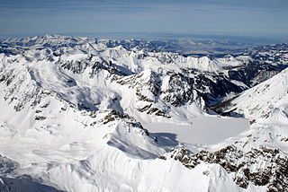
The Schesaplana is the highest mountain in the Rätikon mountain range at the border between Vorarlberg, Austria and Graubunden, Switzerland. It has an elevation of 2,964.3 m (9,725 ft).
Wojciech Kurtyka is a Polish mountaineer and rock climber, one of the pioneers of the alpine style of climbing the biggest walls in the Greater Ranges. He lived in Wrocław up to 1974 when he moved to Kraków. He graduated as engineer in electronics. In 1985 he beat "Shining Wall" Gasherbrum IV, which Climbing magazine declared beat the wall to get the greatest achievement of mountaineering in the twentieth century. In 2016, he received the Piolet d'Or for lifetime achievement in mountaineering.

The Wetterstein mountains, also simply called the Wetterstein, is a mountain group in the Northern Limestone Alps within the Eastern Alps. It is a relatively compact range located between Garmisch-Partenkirchen, Mittenwald, Seefeld in Tirol and Ehrwald. Part of it is in the German free state of Bavaria and part in the Austrian federal state of Tyrol. The main summit of the Wetterstein, the Zugspitze, is also the highest mountain in Germany.

The Mädelegabel is a 2,645 metre high mountain, made of main dolomite, in the Allgäu Alps near Oberstdorf. It is one of the best-known and most-climbed high peaks in the German Alps, Within the Allgäu Alps it is the fourth-highest summit, with rock faces up to 400 metres high. Together with the Trettachspitze and the Hochfrottspitze it forms the famous triumvirate of peaks on the main crest of the Allgäu. Its name comes from Mähder - a mown mountain pasture in the vicinity - and gabel from the appearance of the triumvirate to the north which recalls a fork. Originally the Mädelegabel was the name for all three peaks of the triumvirate; only later were they distinguished from one another by name.

Nasaasaaq is a 784-metre-high (2,572 ft) prominent mountain in the Qeqqata municipality in western Greenland. It is located on the mainland of Greenland, immediately to the southeast of Sisimiut on the northern coast of Amerloq Fjord, a tributary of Davis Strait.

The Bregenz Forest Mountains, also the Bregenzerwald Mountains, are a range of the Northern Limestone Alps, named after the town of Bregenz. The Bregenz Forest Mountains are entirely located in the Austrian state of Vorarlberg.

The Schrammacher is a mountain in the Austrian state of Tyrol. At 3,410 or 3,411 m it is, after the Olperer, the second highest peak of the Tux ridge of the Zillertal Alps. With its horn shape and its steep and smooth northwest wall the mountain is imposing from several directions.

The Schlieferspitze is a mountain, 3,290 m (AA), on the ridge known as the Krimmler Kamm in the Venediger Group of the Alps. The ridge lies in the northwest of the High Tauern, part of the Austrian Central Alps in the Austrian federal state of Salzburg. The summit is the highest on the Krimmler Kamm and is described in the sources as one of the most attractive peaks in the Venediger Group. From the valleys of the Krimmler Achental to the southwest and the Obersulzbachtal to the northeast it appears as an extremely dominant mountain. Long and evenly formed arêtes, about two kilometres long, run from the summit to the northwest, northeast, southeast and southwest. The mountain was first ascended on 22 August 1871 by Eduard Richter, professor of geography at the University of Graz, and Johann Stüdl, a merchant from Prague and co-founder of the German Alpine Club.
The Gleirscher Fernerkogel, also Gleirschfernerkogl, formerly called the Roßkarspitze, is a mountain, 3,189 m (AA), in the Southern Sellrain Mountains, a subgroup of the Stubai Alps. It rises in the Austrian state of Tyrol. The old name, Roßkarspitze, was given to it during the military survey of the region in the 1850s. The first documented ascent was undertaken on 1 September 1883 by Ludwig Purtscheller and Hans Schöller, a "professor from Salzburg". Purtscheller gave the mountain its present name. A prominent 500-metre-long ridge runs eastwards from the unimposing summit.

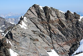
The Panüeler Kopf is a mountain in the Austrian state Vorarlberg. The Panüeler Kopf is part of the Schesaplana group and with an elevation of 2,859 m (AA) the second highest mountain in the Rätikon mountain range. The 950 m high west face is the highest rock face in the Rätikon.

The Wildberg is a 2,788 m (AA) high mountain in the Schesaplana group of the Rätikon mountain range in the Austrian state Vorarlberg.

Tilisuna-Schwarzhorn is a 2,460 m (AA) in the Sulzfluh sub-range of the Rätikon mountain range in the Austrian state Vorarlberg. It has a long ridge from north to south and wide scarps east and west. Besides the main summit, there is a second summit called Kleines Schwarzhorn. Both summits are separated by the col Fürkele. The alpine club hut Tilisunahütte (2208 m) is located near the Tilisuna-Schwarzhorn.


