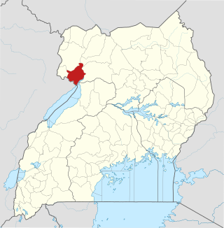
Nebbi District is a district in Northern Uganda. It is named after its main municipal, commercial and administrative centre, Nebbi, the location of the district headquarters.

Arua is a city and commercial centre within the Arua District in the Northern Region of Uganda.

West Nile sub-region, previously known as West Nile Province and West Nile District, is a sub-region in north-western Uganda, in the Northern Region of Uganda.
Pakwach is a town in the Northern Region of Uganda. It is the main commercial, political and administrative center of Pakwach District. In the 19th century the town came under brief occupation by the Ottoman tributary of the Khedivate of Egypt, as part of Hatt-ı Üstuva (Equatoria) Vilayet.
Nebbi is a town in the Nebbi District of the Northern Region of Uganda. It is the site of the district headquarters.
Nyagak Power Station is a 3.5 megawatts (4,700 hp) mini hydroelectric power plant in Uganda.
Bondo is a town in Uganda.

Paidha is a town in the Northern Region of Uganda.
Arua Regional Referral Hospital, commonly known as Arua Hospital is a hospital in the town of Arua, in Northern Uganda. It is the referral hospital for the districts of Adjumani, Arua, Koboko, Maracha, Moyo, Nebbi, Yumbe, and Zombo. The hospital also receives referrals from neighboring parts of South Sudan and the Democratic Republic of the Congo.
Goli is a town in the Northern Region of Uganda.
Zombo District is a district in the Northern Region of Uganda. The town of Zombo is the district's main municipal, administrative, and commercial center,
Muni University (MU) is a public multi-campus university in Uganda. It is one of the public universities and degree-awarding institutions in the country, licensed and supervised by the Uganda National Council for Higher Education (UNCHE).
Saint Luke's Hospital, Angal, commonly known as Angal Hospital , is a private, community hospital in Angal Village, Nebbi District, West Nile sub-region, Northern Uganda.
The Karuma–Olwiyo–Pakwach–Nebbi–Arua Road is a road in the Northern Region of Uganda, connecting the towns of Karuma, Olwiyo, Pakwach, Nebbi and the city of Arua.
Nebbi General Hospital, also Nebbi Hospital, is a hospital in the Northern Region of Uganda.
Parombo is a town in the West Nile sub-region of the Northern Region of Uganda.
Pakwach District is a district in the Northern Region of Uganda. The town of Pakwach is the location of the district headquarters.
The Lira–Gulu–Nebbi–Arua High Voltage Power Line is a high voltage electricity power line, under construction in Uganda. It connects the high voltage substation at Lira, in Lira District, to another high voltage substation at Arua, in Arua District, all in the Northern Region of the country.
St. Aloysius College Nyapea is a boys-only boarding middle and high school located in Zombo District in the West Nile sub-region, in the Northern Region of Uganda. In the 1960s and 1970s the school was a seat of academic excellence. However, it fell on hard times in subsequent years, and as of 2018, was "a shadow of its former self. As from 2019 the former students of the college under the umbrella organisation, St. Aloysius College Nyapea Old Boys Association have introduced both infrastructure development initiatives and students busary schemes aimed at helping the under privileged and poor prospective students with strong academic interest to be sponsored for secondary education. As of 2023, more than 70 students have been enrolled under the scheme. The old boys involvement has led to the college enrollment more than doubling. They are now working with other institutions and people who believe that education is a potent tool in improving people's quality of life to support more prospective students while being cognizant of the social responsibility they bear to the surrounding communities as well".
Nyapea, is a town in Zombo District, West Nile sub-region, in the Northern Region of Uganda.

