The three districts of Luxembourg were the top-level administrative divisions of the Grand Duchy of Luxembourg. The districts were further subdivided into cantons, which still exist:
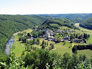
The Ardennes, also known as the Ardennes Forest or Forest of Ardennes, is a region of extensive forests, rough terrain, rolling hills and ridges primarily in Belgium and Luxembourg, extending into Germany and France.
The Eifelkreis Bitburg-Prüm is a district in Rhineland-Palatinate, Germany. It is bounded by Luxembourg, Belgium and the districts of Euskirchen, Vulkaneifel, Bernkastel-Wittlich and Trier-Saarburg.
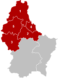
The District of Diekirch was one of three districts of the Grand Duchy of Luxembourg. Immediately prior to its abolition on 3 October 2015, it contained five cantons divided into 43 communes:
- Clervaux
- Diekirch
- Redange
- Vianden
- Wiltz

The Sauer or Sûre is a river in Belgium, Luxembourg, France and Germany. A left tributary of the Moselle, its total length is 173 kilometres (107 mi).

Forêts was a department of the French First Republic, and later the First French Empire, in present-day Belgium, Luxembourg, and Germany. Its name, meaning 'forests', comes from the Ardennes forests. It was formed on 24 October 1795, after the Austrian Netherlands had been annexed by France on 1 October. Before annexation, the territory was part of the Duchy of Luxembourg and small parts of the Duchy of Bouillon. Its capital was Luxembourg City.
The 12 cantons of the Grand Duchy of Luxembourg are subdivisions at the first level of local administrative unit (LAU-1) in the European Union's Nomenclature of Territorial Units for Statistics for Eurostat purposes. They were subdivisions of the three districts of Luxembourg until 2015, when the district level of government was abolished. The cantons are in turn subdivided into 100 communes.

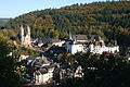
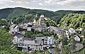
Vianden is a commune with town status in the Éislek region, north-eastern Luxembourg, with a population of 2,203 as of 2023. It is part of the canton of the same name. Vianden lies on the Our river, near the border between Luxembourg and Germany. It is known for the Vianden Castle.

Redange is a canton in the northwest of Luxembourg. Its namesake commune is Redange, officially known as Redange-sur-Attert. It borders the cantons of Wiltz to the north, Diekirch and Mersch to the east, Capellen to the south and Belgium to the west.

The Grand Duchy of Luxembourg is divided into cantons, which group the communes. A dozen of the communes have official city status, and one, Luxembourg City, is unofficially further divided into quarters.

The Guttland is a region covering the southern and central parts of the Grand Duchy of Luxembourg. The Guttland covers 68% of the territory of Luxembourg; to the north of Gutland lies the Éislek, which covers the remaining 32% of the Grand Duchy. To the east, the Luxembourgish Guttland adjoins the Bitburger Gutland of Germany.

The Duchy of Luxembourg was a state of the Holy Roman Empire, the ancestral homeland of the noble House of Luxembourg. The House of Luxembourg became one of the most important political forces in the 14th century, competing against the House of Habsburg for supremacy in Central Europe. They would be the heirs to the Přemyslid dynasty in the Kingdom of Bohemia, succeeding to the Kingdom of Hungary and contributing four Holy Roman Emperors until their own line of male heirs came to an end and the House of Habsburg received the territories that the two Houses had originally agreed upon in the Treaty of Brünn in 1364.

The County of Luxembourg was a State of the Holy Roman Empire. It arose from medieval Lucilinburhuc Castle in the present-day City of Luxembourg, purchased by Siegfried, Count of the Ardennes in 963. His descendants of the Ardennes–Luxembourg dynasty began to call themselves Counts of Luxembourg from the 11th century onwards. The House of Luxembourg, a cadet branch of the Dukes of Limburg, became one of the most important political forces of the 14th century, contending with the House of Habsburg for supremacy in the Holy Roman Empire.
The Counts of Vianden, ancestors of the House of Orange-Nassau, were associated with the castle of Vianden in Luxembourg.

Affler is a municipality in the district of Bitburg-Prüm, in Rhineland-Palatinate, western Germany.

Dockendorf is a municipality in the district of Bitburg-Prüm, in Rhineland-Palatinate, western Germany.

Tourism is an important component of the national economy of Luxembourg, representing about 8.3% of GDP in 2009 and employing some 25,000 people or 11.7% of the working population. Despite the 2008–2012 global recession, the Grand Duchy still welcomes over 900,000 visitors a year who spend an average of 2.5 nights in hotels, hostels or on camping sites. Business travel is flourishing representing 44% of overnight stays in the country and 60% in the capital, up 11% and 25% between 2009 and 2010. Published by the World Economic Forum in March 2011, the Travel and Tourism Competitiveness Report puts Luxembourg in 15th place worldwide, up from 23rd place in 2009.

The involvement of the Grand Duchy of Luxembourg in World War II began with its invasion by German forces on 10 May 1940 and lasted beyond its liberation by Allied forces in late 1944 and early 1945.

The German-Luxembourg Nature Park is a cross-border nature park, which was established on 17 April 1964 by state treaty between the German state of Rhineland-Palatinate and the Grand Duchy of Luxembourg. It thus became the first cross-border nature park in Western Europe. On the German side Naturpark Südeifel is providing services for visitors.

The Our Nature Park is a nature park in north-eastern Luxembourg.