
Cappadocia is a historical region in Central Anatolia, Turkey. It is largely in the provinces of Nevşehir, Kayseri, Aksaray, Kırşehir, Sivas and Niğde.
Cappadocian Greek, also known as Cappadocian is a dialect of modern Greek, originally spoken in Cappadocia by the descendants of the Byzantine Greeks of Anatolia. The language originally diverged from Medieval Greek after the late medieval migrations of the Turks from Central Asia into what is now Turkey began cutting the Cappadocians off from the rest of the Greek-speaking Byzantine Empire. As a result of the population exchange between Greece and Turkey in 1923, all remaining speakers were forced to emigrate to Greece where they were resettled in various locations, primarily in Central and Northern Greece. The Cappadocians were encouraged to shift to Standard Modern Greek as part of their integration into Greece, and their language was thought to be extinct since the 1960s. In June 2005, Mark Janse and Dimitris Papazachariou discovered Cappadocians in Central and Northern Greece who could still speak their ancestral language fluently. Many are middle-aged, third-generation speakers who take a very positive attitude towards the language, as opposed to their parents and grandparents. The latter are much less inclined to speak Cappadocian and more often than not switch to Standard Modern Greek.

Göreme is a town (belde) in the Nevşehir District, Nevşehir Province in Central Anatolia, Turkey. Its population is 2,034 (2022). It is well known for its fairy chimneys, eroded rock formations, many of which were hollowed out in the Middle Ages to create Christian churches, houses and underground cities. Göreme was formerly known as Korama, Matiana, Macan and Avcilar.

Niğde is a city and the capital of in the Central Anatolia region of Turkey. It is the seat of Niğde Province and Niğde District. Its population is 170,511 (2022). It lies at an elevation of 1,276 m (4,186 ft).

Nevşehir is a city in the Central Anatolia Region of Turkey. It is the seat of Nevşehir Province and Nevşehir District. Its population is 123,882 (2022). It is 290 km (180 mi) from the capital Ankara and lies within the historical region of Cappadocia.
Ihlara, formerly known as Chliára is a town (belde) and municipality in the Güzelyurt District, Aksaray Province, Turkey. The population is 2,289 (2021). It is situated at about 40 km (25 mi) from the province seat of Aksaray and near the town of Güzelyurt. The township is famed for the nearby valley of the same name, Ihlara Valley, which is a 16 km (10 mi) long gorge cut into volcanic rock in the southern part of Cappadocia, following several eruptions of Mount Erciyes. The Melendiz River flows through the valley.
Derinkuyu is a town in Nevşehir Province in the Central Anatolia region of Turkey. It is the seat of Derinkuyu District. Its population is 10,912 (2022). The elevation is 1,333 m (4,373 ft).

Güzelyurt, meaning 'beautiful homeland', formerly Gelveri, is a town in Aksaray Province in the Central Anatolia region of Turkey, at a distance of 45 km (28 mi) from the city of Aksaray. It is the seat of Güzelyurt District. Its population is 2,570 (2021). Its elevation is 1,485 m (4,872 ft).

Misthi or Misti was a Greek city in the region of Cappadocia, which is in modern-day Turkey. It was situated 82 kilometres southwest of the regional capital, Caesarea, now known as Kayseri, Turkey. Administratively, it was a part of the nearby city of Niğde, situated 26 kilometres north-northwest at an altitude of 1380 metres above sea level. The current name of the town is Konaklı.
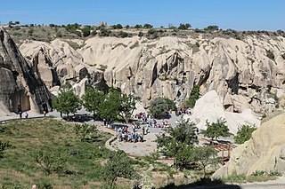
Göreme is a district of the Nevşehir Province in Turkey. After the eruption of Mount Erciyes about 2.6 million years ago, ash and lava formed soft rocks in the Cappadocia region, covering a region of about 20,000 square kilometres (7,700 sq mi). The softer rock was eroded by wind and water, leaving the hard cap rock on top of pillars, forming the present-day fairy chimneys. People of Göreme, at the heart of the Cappadocia region, realized that these soft rocks could be easily carved out to form houses, churches, and monasteries. These Christian sanctuaries contain many examples of Byzantine art from the post-iconoclastic period. These frescos are a unique artistic achievement from this period.
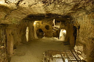
Kaymakli underground city is contained within the citadel of Kaymakli in the Central Anatolia Region of Turkey. First opened to tourists in 1964, the village is about 19 km from Nevşehir, on the Nevşehir-Niğde road.

Derinkuyu also known as Elengubu, is an ancient multi-level underground city near the modern town of Derinkuyu in Nevşehir Province, Turkey, extending to a depth of approximately 85 metres (280 ft). It is large enough to have sheltered as many as 20,000 people together with their livestock and food stores. It is the largest excavated underground city in Turkey and is one of several underground complexes found throughout Cappadocia.

John the Russian is one of the most renowned saints in the Eastern Orthodox Church. Being a prisoner of war and a slave to a Turkish Ağa, he became famous and respected even by his Muslim master for his humility, steadiness in faith and benevolence. His holy relics are claimed to be undecayed and wonder-working; there are traditions that this saint particularly helps sick children and those who suffer from cancer.

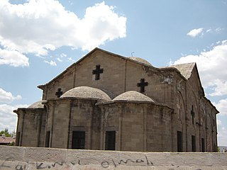
Eski Gümüşler Monastery is a Byzantine-era cave monastery in the small town of Gümüşler, 10km northeast of Niğde town in Niğde province, Turkey. It is easily accessible by bus from Niğde.
The Kayakapi neighbourhood of Ürgüp, Turkey is a historical area located on the northeastern slope of a hill known as Esbelli. It features many examples of vernacular and monumental architecture, including the House of Saint John the Russian (Yuhannes). Abandoned after the 1980s, the semi-ruins and natural landscape of Kayakapi are now being developed for tourism.
The Cappadocian Greeks, or simply Cappadocians, are an ethnic Greek community native to the geographical region of Cappadocia in central-eastern Anatolia; roughly the Nevşehir and Kayseri provinces and their surroundings in modern-day Turkey. There had been a continuous Greek presence in Cappadocia since antiquity, and the indigenous populations of Cappadocia, some of whose Indo-European languages may have been closely related to Greek became entirely Greek-speaking by at least the 5th century CE.

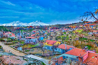
Mustafapaşa, formerly known as Sinasos, is a village in the Ürgüp District of Nevşehir Province, Turkey. Its population is 1,295 (2022). Before the 2013 reorganisation, it was a town (belde). It lies to the west of Gomeda valley and is 5 kilometres (3.1 mi) away from Ürgüp and 27 kilometres (17 mi) away from Nevşehir town.
Uçhisar is a town (belde) in the Nevşehir District, Nevşehir Province in Cappadocia, Turkey. Its population is 3,555 (2022). It is 7 kilometres east of Nevşehir, 12 kilometres west of Ürgüp, and 10 kilometres south of Avanos.
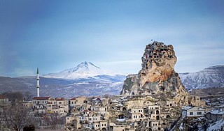
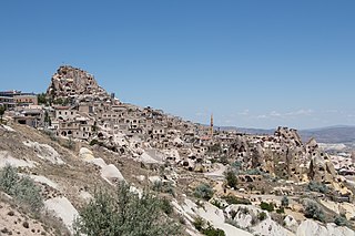
Ortahisar, previously known by its Byzantine name Potamía, is a town (belde) in the Ürgüp District, Nevşehir Province, Turkey. Its population is 3,086 (2022). Ortahisar is located about 20 km east of the provincial capital, Nevşehir.

Caesarea, also known historically as Mazaca, was an ancient city in what is now Kayseri, Turkey. In Hellenistic and Roman times, the city was an important stop for merchants headed to Europe on the ancient Silk Road. The city was the capital of Cappadocia, and Armenian and Cappadocian kings regularly fought over control of the strategic city. The city was renowned for its bishops of both the Greek Orthodox and Armenian Apostolic churches. After the Battle of Manzikert where the Byzantine Empire lost to the incoming Seljuk Empire, the city was later taken over by the Sultanate of Rum and became reconfigured over time with the influences of both Islamic and, later, Ottoman architecture.


