Česma

Last updated
Česma

Cesma-Narta.jpg

Česma river at Narta near Bjelovar.
Country Croatia
Physical characteristics
Main source 114 m (374 ft)
River mouth Lonja
84 m (276 ft)
45°34′31″N16°28′16″E / 45.57528°N 16.47111°E / 45.57528; 16.47111 Coordinates: 45°34′31″N16°28′16″E / 45.57528°N 16.47111°E / 45.57528; 16.47111
Length 105.7 km (65.7 mi) [1]
Discharge
  • Average rate:
    14.1 m3/s (500 cu ft/s)
Basin features
Progression LonjaSavaDanubeBlack Sea
Basin size 3,253 km2 (1,256 sq mi) [1]
Tributaries

Česma is a river in central Croatia, a left tributary of the river Lonja-Trebež. It is 106 km (66 mi) long, and its catchment area is 3,253 km2 (1,256 sq mi). [1]

River Natural flowing watercourse

A river is a natural flowing watercourse, usually freshwater, flowing towards an ocean, sea, lake or another river. In some cases a river flows into the ground and becomes dry at the end of its course without reaching another body of water. Small rivers can be referred to using names such as stream, creek, brook, rivulet, and rill. There are no official definitions for the generic term river as applied to geographic features, although in some countries or communities a stream is defined by its size. Many names for small rivers are specific to geographic location; examples are "run" in some parts of the United States, "burn" in Scotland and northeast England, and "beck" in northern England. Sometimes a river is defined as being larger than a creek, but not always: the language is vague.

Croatia Republic in Central Europe

Croatia, officially the Republic of Croatia is a country at the crossroads of Central and Southeast Europe, on the Adriatic Sea. It borders Slovenia to the northwest, Hungary to the northeast, Serbia to the east, Bosnia and Herzegovina, and Montenegro to the southeast, sharing a maritime border with Italy. Its capital, Zagreb, forms one of the country's primary subdivisions, along with twenty counties. Croatia has an area of 56,594 square kilometres and a population of 4.28 million, most of whom are Roman Catholics.

Created by merging streams Grđevica and Barna at 45°43′32″N17°03′01″E / 45.72556°N 17.05028°E / 45.72556; 17.05028 near the village of Pavlovac in the municipality of Veliki Grđevac. Česma basin is fan-shaped and formed by a number of streams rising on the slopes of Bilogora and Moslavačka gora hills. Southern sides of Bilogora slightly goes downhill, rugged with numerous ravines and gullies, steeply and deeply cut in. On the sides appears numerous springs, that in the dry part of the year losing water.

Stream A body of surface water flowing down a channel

A stream is a body of water with surface water flowing within the bed and banks of a channel. The stream encompasses surface and groundwater fluxes that respond to geological, geomorphological, hydrological and biotic controls.

Pavlovac, Bjelovar-Bilogora County Village in Croatia

Pavlovac is a village in the municipality Veliki Grđevac, Bjelovar-Bilogora County in Croatia. According to the 2001 census, there are 679 inhabitants, in 242 family households.

Veliki Grđevac Municipality in Croatia

Veliki Grđevac ) is a municipality in Bjelovar-Bilogora County, Croatia. According to the 2001 census, there are 3,248 inhabitants, 80.41% of which are Croats, in 1,157 of family households.

It has a small drop (small difference in altitude between the source and the mouth) which was causing frequent floods before the regulation of the riverbed. The area around the watercourse of Česma till a hundred years ago was subject of flooding, which is why it was swampy. After that, Česma river and its tributaries was channelized, embankments were built for flood protection, and the soil is dried to obtain arable land as well as the fight against malaria.

Flood Overflow of water that submerges land that is not normally submerged

A flood is an overflow of water that submerges land that is usually dry. In the sense of "flowing water", the word may also be applied to the inflow of the tide. Floods are an area of study of the discipline hydrology and are of significant concern in agriculture, civil engineering and public health.

Stream bed channel bottom of a stream, river, or creek

A stream bed or streambed is the channel bottom of a stream or river, the physical confine of the normal water flow. The lateral confines or channel margins are known as the stream banks or river banks, during all but flood stage. Under certain conditions a river can branch from one stream bed to multiple stream beds. A flood occurs when a stream overflows its banks and flows onto its flood plain. As a general rule, the bed is the part of the channel up to the normal water line, and the banks are that part above the normal water line. However, because water flow varies, this differentiation is subject to local interpretation. Usually, the bed is kept clear of terrestrial vegetation, whereas the banks are subjected to water flow only during unusual or perhaps infrequent high water stages and therefore might support vegetation some or much of the time.
Watercourse channel that a flowing body of water follows

A watercourse is the channel that a flowing body of water follows. In the UK, some aspects of criminal law, such as The Rivers Act 1951, specify that a watercourse includes those rivers which are dry for part of the year.

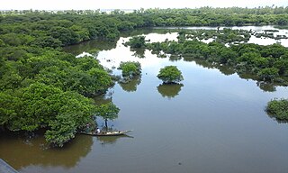
At the site of former wetlands now are fish ponds that supply water from streams that flows into the Česma river. These ponds are one of the last refuge of wading birds between the Drava and Sava rivers.
Wetland A land area that is permanently or seasonally saturated with water

A wetland is a distinct ecosystem that is inundated by water, either permanently or seasonally, where oxygen-free processes prevail. The primary factor that distinguishes wetlands from other land forms or water bodies is the characteristic vegetation of aquatic plants, adapted to the unique hydric soil. Wetlands play a number of functions, including water purification, water storage, processing of carbon and other nutrients, stabilization of shorelines, and support of plants and animals. Wetlands are also considered the most biologically diverse of all ecosystems, serving as home to a wide range of plant and animal life. Whether any individual wetland performs these functions, and the degree to which it performs them, depends on characteristics of that wetland and the lands and waters near it. Methods for rapidly assessing these functions, wetland ecological health, and general wetland condition have been developed in many regions and have contributed to wetland conservation partly by raising public awareness of the functions and the ecosystem services some wetlands provide.

Fish pond body of standing water, man-made and non perennial, used for pisciculture

A fish pond, or fishpond, is a controlled pond, artificial lake, or reservoir that is stocked with fish and is used in aquaculture for fish farming, or is used for recreational fishing or for ornamental purposes. In the medieval European era it was typical for monasteries and castles to have a fish pond.

Wader

Waders are birds commonly found along shorelines and mudflats that wade in order to forage for food in the mud or sand. They are called shorebirds in North America, where the term "wader" is used to refer to long-legged wading birds such as storks and herons. Waders are members of the order Charadriiformes, which includes gulls, auks and their allies.

Along Česma river there are several major fish farming complexes. North of Česma fish pondribnjačastvo Dubrava, and along the southern coast fish ponds — Siščani, Blatnica and Narta. Both complexes are spread at about 5 kilometers along the course Česma river, and environment are similar. They are about 5 kilometers away to each other. The total area covered by commercial fish ponds is 1,346 ha (3,330 acres). [2]

Fish farming Raising fish commercially in enclosures

Fish farming or pisciculture involves raising fish commercially in tanks or enclosures such as fish ponds, usually for food. It is the principal form of aquaculture, while other methods may fall under mariculture. A facility that releases juvenile fish into the wild for recreational fishing or to supplement a species' natural numbers is generally referred to as a fish hatchery. Worldwide, the most important fish species produced in fish farming are carp, tilapia, salmon, and catfish.

Related Research Articles

Geography of Ghana

Ghana is a country in Africa, along the Gulf of Guinea, just a few degrees north of the equator. Wikimedia Atlas of Ghana

Yellow River second longest river in China

The Yellow River or Huang He is the second longest river in Asia, after the Yangtze River, and the sixth longest river system in the world at the estimated length of 5,464 km (3,395 mi). Originating in the Bayan Har Mountains in Qinghai province of Western China, it flows through nine provinces, and it empties into the Bohai Sea near the city of Dongying in Shandong province. The Yellow River basin has an east–west extent of about 1,900 kilometers (1,180 mi) and a north–south extent of about 1,100 km (680 mi). Its total drainage area is about 752,546 square kilometers (290,560 sq mi).

Zambezi fourth-longest river in Africa

The Zambezi is the fourth-longest river in Africa, the longest east-flowing river in Africa and the largest flowing into the Indian Ocean from Africa. The area of its basin is 1,390,000 square kilometres (540,000 sq mi), slightly less than half of the Nile's. The 2,574-kilometre-long river (1,599 mi) rises in Zambia and flows through eastern Angola, along the eastern border of Namibia and the northern border of Botswana, then along the border between Zambia and Zimbabwe to Mozambique, where it crosses the country to empty into the Indian Ocean.

Tulare Lake

Tulare Lake, Laguna de Tache in Spanish, is a freshwater dry lake with residual wetlands and marshes in the southern San Joaquin Valley, California, United States. After Lake Cahuilla disappeared in the 17th century, Tulare Lake was the largest freshwater lake west of the Mississippi River and the second-largest freshwater lake entirely in the United States, based upon surface area. A remnant of Pleistocene-era Lake Corcoran, Tulare Lake dried up after its tributary rivers were diverted for agricultural irrigation and municipal water uses.

Gila River river in the United States of America

The Gila River is a 649-mile (1,044 km) tributary of the Colorado River flowing through New Mexico and Arizona in the United States. The river drains an arid watershed of nearly 60,000 square miles (160,000 km2) that lies mainly within the U.S. but also extends into northern Sonora, Mexico. Indigenous peoples have lived along the river for at least 2,000 years, establishing complex agricultural societies before European exploration of the region began in the 16th century. However, European Americans did not permanently settle the Gila River watershed until the mid-19th century.

Sava river in Southeast Europe

The Sava is a river in Central and Southeastern Europe, a right tributary of the Danube. It flows through Slovenia, Croatia, along the northern border of Bosnia and Herzegovina, and through Serbia, discharging into the Danube in Belgrade. Its central part is a natural border of Bosnia-Herzegovina and Croatia. The Sava forms the northern border of the Balkan Peninsula, and the southern edge of the Pannonian Plain.

River Tywi river in Wales, Wales

The River Tywi or Towy is the longest river flowing entirely within Wales. Its total length is 120 km (75 mi). It is noted for its sewin and salmon fishing.

Kapuas River river in Kalimantan, Indonesia

The Kapuas River is a river in the Indonesian part of Borneo island, at the geographic center of Maritime Southeast Asia. At 1,143 kilometers (710 mi) in length, it is the longest river of Indonesia and one of the world's longest island rivers. It originates in the Müller mountain range at the center of the island and flows west into the South China Sea creating an extended marshy delta. The delta is located west-southwest of Pontianak, the capital of the West Kalimantan province. This Kapuas River should be distinguished from another Kapuas River, which starts on the other side of the same mountain range in central Borneo, but flows to the south, merging with the Barito River and discharging into the Java Sea.

Red Deer River river in Alberta, Canada

The Red Deer River is a river in Alberta and a small portion of Saskatchewan, Canada. It is a major tributary of the South Saskatchewan River and is part of the larger Saskatchewan-Nelson system that empties into Hudson Bay.

Karamana River river in India

Karamana is a river flowing through the city of

Thiruvananthapuram in Kerala, India. The river starts near the southern tip of the Western Ghats at Agastyar Koodam. The river flows 66 km westward and merges with the Arabian Sea at Panathura near Kovalam. The river gets its name from Karamana, a suburb of Thiruvananthapuram city, Aryanad through which it flows.
Lim (river) river

The Lim is a river flowing through Montenegro, Albania, Serbia and Bosnia and Herzegovina. 220 km (137 mi) long, it is the right and the longest tributary of the Drina.

Bosut (river)

The Bosut is a river in eastern Croatia and northwestern Serbia, a 186 km long left tributary of the Sava river. Its name from the Indo-European root *bhogj, meaning "to flow". The same root is seen in hydronym "Bosna".

Obedska bara

Obedska bara is a large swamp-forest area and natural reserve stretching along the Sava River in Southern Syrmia (Serbia), some 40 km west of Belgrade.

Crab Creek

Crab Creek is a stream in the U.S. state of Washington. Named for the presence of crayfish, it is one of the few perennial streams in the Columbia Basin of central Washington, flowing from the northeastern Columbia River Plateau, roughly 5 km (3.1 mi) east of Reardan, west-southwest to empty into the Columbia River near the small town of Beverly. Its course exhibits many examples of the erosive powers of extremely large glacial Missoula Floods of the late Pleistocene, which scoured the region. In addition, Crab Creek and its region have been transformed by the large-scale irrigation of the Bureau of Reclamation's Columbia Basin Project (CBP), which has raised water table levels, significantly extending the length of Crab Creek and created new lakes and streams.

San Juan Creek

San Juan Creek, also called the San Juan River, is a 29-mile (47 km) long stream in Orange County, California draining a watershed of 133.9 square miles (347 km2). Its mainstem begins in the southern Santa Ana Mountains in the Cleveland National Forest. It winds west and south through San Juan Canyon, and is joined by Arroyo Trabuco as it passes through San Juan Capistrano. It flows into the Pacific Ocean at Doheny State Beach. San Juan Canyon provides a major part of the route for California State Route 74.

Drina river, which forms a large portion of the border between Bosnia and Herzegovina and Serbia

The Drina is a 346 km (215 mi) long international river, which forms a large portion of the border between Bosnia and Herzegovina and Serbia. It is the longest tributary of the Sava River and the longest karst river in the Dinaric Alps which belongs to the Danube river watershed. Its name is derived from the Latin name of the river which in turn is derived from Greek.

Bilogora is a low mountainous range in central Croatia. It consists of a series of hills and small plains some 80 kilometres in length stretching in the direction northwest-southeast, along the southwest part of the Podravina region. The highest peak is called Rajčevica, located in the north of the mountain.

Lonja is a river in central Croatia, a left tributary of the Sava. It is 49 kilometres (30 mi) long and its basin covers an area of 4,259 square kilometres (1,644 sq mi).

Ilova (Sava) river in Croatia

Ilova is a river in central Croatia, a left tributary of the Sava. It is 104.6 kilometres (65.0 mi) long and its basin covers an area of 1,796 square kilometres (693 sq mi).

H.F. Lee Energy Complex

The H.F. Lee Energy Complex, formerly the Goldsboro Plant, is an electrical power generating complex operated by Duke Energy. The power complex was originally owned by the Carolina Power & Light Company, which inaugurated a coal-fired power plant in 1951. Two more coal plants were added in 1952 and 1962, and then oil-fueled turbines were added in 1967–71. In 2012 these units were shut down and replaced by four gas-fired units. The Quaker Neck Lake was built as a cooling pond for the coal-fired power stations, and is still used to supply cooling water. It was originally impounded by a low dam on the Neuse River, but in 1998 the dam was removed, while the lake remained contained in an earthen wall. This change allowed fish to migrate further upstream for spawning. Ash ponds near the lake hold toxic coal ash. There are plans to remove and recycle or bury the ash.

References

  1. 1 2 3 "Sava River Basin Analysis Report" (PDF, 9.98 MB). International Sava River Basin Commission. September 2009. p. 13. Retrieved 2018-05-18.
  2. Prostorni plan Bjelovarsko – bilogorske županije (Spatial plan of Bjelovar-Bilogora County) Archived July 21, 2011, at the Wayback Machine .