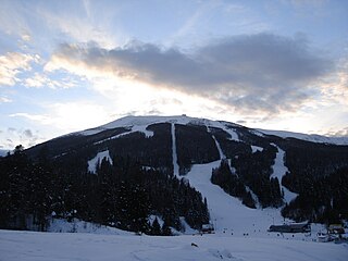
Bjelašnica is a mountain in the Dinaric Alps in central Bosnia and Herzegovina. It is to the southwest of Sarajevo, bordering Mount Igman. Bjelašnica's tallest peak, by which the mountain group got its name, rises to an elevation of 2,067 metres (6,781 ft). Other notable peaks are Krvavac, Mali Vlahinja, and Hranisava. The Bjelašnica range is bordered by the Rakitnica in the south, the Neretva in the west, Mount Igman in the north-east and Mount Ivan in the north-west. Only at 20 minutes distance of Sarajevo, it is a tourist attraction for hiking and skiing.
The West Herzegovina Canton is one of the cantons of the Federation of Bosnia and Herzegovina. The West Herzegovina Canton is in the Herzegovina region in the southwest of Bosnia and Herzegovina. Its seat of government is in Široki Brijeg, while other municipalities within the Canton are Grude, Ljubuški and Posušje. It has 94,898 inhabitants, of whom more than 98% are ethnic Croats. Economically, it is the most developed part of Bosnia and Herzegovina.

The Neretva, also known as Narenta, is one of the largest rivers of the eastern part of the Adriatic basin. Four hydroelectric power plants with large dams provide flood protection, electricity and water storage. The Neretva is recognized for its natural environment and diverse landscapes.

Livno is a city and the administrative center of Canton 10 of the Federation of Bosnia and Herzegovina, an entity of Bosnia and Herzegovina. It is situated on the river Bistrica in the southeastern edge of the Livno Field at the foot of Kruzi plateau which are located beneath the Cincar mountain and rocky hill Crvenice. Livno is the centre of the Canton 10 which mainly covers an area of the historical and geographical region of Tropolje. As of 2013, it has a population of 37,487 inhabitants. The town, with its historic ruins and old town from the 9th century, was first mentioned in 892, developing at the crossroads between the Adriatic coast and inland, i.e., regions of Bosnia, Dalmatia, Herzegovina, and Krajina.
Jablanica is a town and municipality located in the Herzegovina-Neretva Canton of the Federation of Bosnia and Herzegovina, an entity of Bosnia and Herzegovina. It is situated on the Neretva river and Jablanica lake.

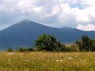
Troglav is the highest peak of the Dinara Mountain Range in the Dinaric Alps. Dinara is the longest massif within karstic mountain chain of the western Balkan peninsula. Troglav is located in the territory of Bosnia and Herzegovina. It is named after Triglav, Slavic god. The name literally means "three headed".

Orjen is a transboundary Dinaric Mediterranean limestone mountain range, located between southernmost Bosnia and Herzegovina and southwestern Montenegro.

Livanjsko polje, located in Bosnia and Herzegovina, is the largest polje in the world and a RAMSAR wetland site. A typical example of karst polje encircled by tall peaks and mountain ranges, the field is characterized by many unique natural phenomenons and karstic features.
The Trebišnjica is a river in Bosnia and Herzegovina, and the right tributary of the Neretva. Before it was utilized for hydro exploitation via various hydrotechnical interventions and systems with different purposes, Trebišnjica used to be a sinking river, rising and sinking through its course before resurfacing at various places from the Neretva river below the Čapljina to the Adriatic coast, and along the coast from the Neretva Delta to Sutorina.

Blidinje plateau is a karst plateau in Bosnia and Herzegovina, situated at the heart of Dinaric Alps, between major mountains of the range, Čvrsnica, Čabulja and Vran, with characteristic karstic features such as Dugo Polje field, Blidinje Lake, Grabovica and Drežnica valleys, and others. It represents important natural, hydrogeological reservation in karst of Bosnia and Herzegovina, with significant cultural and historical heritage, and Dinarides in general.

The Trebižat is a river in the southern part of Bosnia and Herzegovina, and major right tributary of the Neretva River.
Šator is a mountain in the Dinaric Alps, in the western regions of Bosnia and Herzegovina. The name šator means "tent". The highest peak Veliki Šator is 1,872 m (6,142 ft) above sea level. Dimensions of the mountain are some 15 km in the west–east and 10 km in the north–south direction.

Vran is a mountain in the municipality of Tomislavgrad, Bosnia and Herzegovina. It has an altitude of 2,074 metres (6,804 ft). Vran along the Čvrsnica, Dugo Polje, and other karstic features forms the Blidinje plateau.
The fish fauna of the Neretva river basin in the western Balkans is representative of the Dinaric karst region and characterized by several endemic and endangered species.

The Doljanka River is a right tributary of the Neretva river in North Herzegovina, Bosnia and Herzegovina.

The Zalomka is a karstic river in the southern part of Bosnia and Herzegovina, and as part of the Neretva river system it is one of the largest sinking rivers in the country and Dinarides. It rises under the Morine plateau, near Brajićevići village in Gacko municipality, but also collects its upper course waters from Gatačko Polje.

North Herzegovina, also called High Herzegovinian, is a region of Herzegovina surrounding the Upper Neretva. It includes municipalities Jablanica, Konjic in Herzegovina-Neretva Canton, and in Republika Srpska, Ulog, Kalinovik, parts of Nevesinje and Gacko. It encompassing High Herzegovinian mountain region of the Dinaric Alps, with mountains Vran, Čabulja, Čvrsnica, Prenj, Raduša, Bitovnja, Bjelašnica, Visočica, Crvanj, Treskavica, Lelija, Zelengora, Maglić, Volujak, and high plateau of Blidinje, and micro-regions like Morine and Rudine above Gacko. and Glavatičevo on the Neretva.

Drežnica Valley or Drežanka Canyon is a valley surrounding a mountain stream Drežanka, which cuts through a deep 29 kilometers long karstic gorge between mountains Čvrsnica and Čabulja, part of the Dinaric Alps range. The stream is right tributary of the Neretva, and a valley follows the west-east axes. The main settlements are Gornja Drežnica and Donja Drežnica with their numerous hamlets, and are part of the territory of the city of Mostar, in Bosnia and Herzegovina.
Drežanka is a mountain stream and a right tributary of the Neretva. It flows through Drežnica Valley and the settlements of Gornja Drežnica and Donja Drežnica on the territory of the city of Mostar, in Bosnia and Herzegovina.
Veliki Movran or simply Movran, is a waterfall in Bosnia and Herzegovina. The waterfall falls from the cliffs of Čvrsnica into the Drežnica Valley, through which runs a small mountain river of Drežanka, a right tributary of the Neretva. It appears intermittently, in the late winter and during spring in the season of snow melting, or during heavy and prolonged rainfall, usually in late autumn, winter and early spring.

