Šarišské Sokolovce

Last updated
Location of Sabinov District in the Presov Region. Okres sabinov.png
Location of Sabinov District in the Prešov Region.

Šarišské Sokolovce is a village and municipality in Sabinov District in the Prešov Region of north-eastern Slovakia.

Village Small clustered human settlement smaller than a town

A village is a clustered human settlement or community, larger than a hamlet but smaller than a town, with a population ranging from a few hundred to a few thousand. Though villages are often located in rural areas, the term urban village is also applied to certain urban neighborhoods. Villages are normally permanent, with fixed dwellings; however, transient villages can occur. Further, the dwellings of a village are fairly close to one another, not scattered broadly over the landscape, as a dispersed settlement.

Municipality An administrative division having corporate status and usually some powers of self-government or jurisdiction

A municipality is usually a single urban administrative division having corporate status and powers of self-government or jurisdiction as granted by national and regional laws to which it is subordinate. It is to be distinguished (usually) from the county, which may encompass rural territory or numerous small communities such as towns, villages and hamlets.

Sabinov District District in Prešov Region, Slovakia

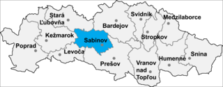
Sabinov District is a district in the Prešov Region of eastern Slovakia. It lies on the highlands of Šarišská vrchovina. The district had been established in 1923 and from 1996 exists in its present borders. Food, pharmaceutical and clothing industry and located foremost in its towns and Šarišské Michaľany. In the district are three recreational centers, mainly used during winter and skiing season. Overall, the district suffers from the high unemployment rate. In Sabinov district are 43 municipalities, in two of them are towns.

Contents

Names and etymology

The former Slovak name Tolčemeš derives from Hungarian TóthSlav/Slovak and sólyom – a hawk (Slovak sokol). [1] It was given its current official name in 1948.

Slovak language language spoken in Slovakia

Slovak or less frequently Slovakian is a West Slavic language. It is called slovenský jazyk or slovenčina in the language itself.

Slavs Indo-European ethno-linguistic group living in Central Europe, Eastern Europe, Southeast Europe, North Asia and Central Asia

Slavs are an Indo-European ethno-linguistic group who speak the various Slavic languages of the larger Balto-Slavic linguistic group. They are native to Eurasia, stretching from Central, Eastern, and Southeastern Europe all the way north and eastwards to Northeast Europe, Northern Asia (Siberia), the Caucasus, and Central Asia as well as historically in Western Europe and Western Asia. From the early 6th century they spread to inhabit the majority of Central, Eastern and Southeastern Europe. Today, there is a large Slavic diaspora throughout North America, particularly in the United States and Canada as a result of immigration.

The Slovaks or Slovak people are a nation and West Slavic ethnic group native to Slovakia who share a common ancestry, culture, history and speak the Slovak language.

History

The village was probably founded already in the 11th or the 12th century by Slovak falconers. [1] In historical records the village was first mentioned in 1307. [1]

History past events and their record

History is the study of the past as it is described in written documents. Events occurring before written record are considered prehistory. It is an umbrella term that relates to past events as well as the memory, discovery, collection, organization, presentation, and interpretation of information about these events. Scholars who write about history are called historians.

Geography

The municipality lies at an altitude of 431 metres and covers an area of 12.268 km². It has a population of about 515 people.

Altitude or height is defined based on the context in which it is used. As a general definition, altitude is a distance measurement, usually in the vertical or "up" direction, between a reference datum and a point or object. The reference datum also often varies according to the context. Although the term altitude is commonly used to mean the height above sea level of a location, in geography the term elevation is often preferred for this usage.

Area quantity that expresses the extent of a two-dimensional surface or shape, or planar lamina, in the plane

Area is the quantity that expresses the extent of a two-dimensional figure or shape, or planar lamina, in the plane. Surface area is its analog on the two-dimensional surface of a three-dimensional object. Area can be understood as the amount of material with a given thickness that would be necessary to fashion a model of the shape, or the amount of paint necessary to cover the surface with a single coat. It is the two-dimensional analog of the length of a curve or the volume of a solid.

Population All the organisms of a given species that live in the specified region

In biology, a population is all the organisms of the same group or species, which live in a particular geographical area, and have the capability of interbreeding. The area of a sexual population is the area where inter-breeding is potentially possible between any pair within the area, and where the probability of interbreeding is greater than the probability of cross-breeding with individuals from other areas.

Related Research Articles

Koprivnica, Bardejov District municipality of Slovakia

Koprivnica is a village and municipality in Bardejov District in the Prešov Region of north-east Slovakia.

Lascov municipality of Slovakia

Lascov is a village and municipality in Bardejov District in the Prešov Region of north-east Slovakia.

Marhaň municipality of Slovakia

Marhaň is a village and municipality in Bardejov District in the Prešov Region of north-east Slovakia.

Osikov municipality of Slovakia

Osikov is a village and municipality in Bardejov District in the Prešov Region of north-east Slovakia.

Sveržov municipality of Slovakia

Sveržov is a village and municipality in Bardejov District in the Prešov Region of north-east Slovakia.

Tarnov, Bardejov District municipality of Slovakia

Tarnov is a village and municipality in Bardejov District in the Prešov Region of north-east Slovakia.

Vaniškovce municipality of Slovakia

Vaniškovce is a village and municipality in Bardejov District in the Prešov Region of north-east Slovakia.

Ruská Kajňa municipality of Slovakia

Ruská Kajňa is a village and municipality in Humenné District in the Prešov Region of north-east Slovakia.

Malý Slivník municipality of Slovakia

Malý Slivník is a village and municipality in Prešov District in the Prešov Region of eastern Slovakia.

Mošurov municipality of Slovakia

Mošurov is a village and municipality in Prešov District in the Prešov Region of eastern Slovakia.

Terňa municipality of Slovakia

Terňa is a village and municipality in Prešov District in the Prešov Region of eastern Slovakia.

Veľký Slivník municipality of Slovakia

Veľký Slivník is a village and municipality in Prešov District in the Prešov Region of eastern Slovakia.

Župčany municipality of Slovakia

Župčany is a village and municipality in Prešov District in the Prešov Region of eastern Slovakia.

Dukovce municipality of Slovakia

Dukovce is a village and municipality in Svidník District in the Prešov Region of north-eastern Slovakia.

Kuková municipality of Slovakia

Kuková is a village and municipality in Svidník District in the Prešov Region of north-eastern Slovakia.

Lužany pri Topli municipality of Slovakia

Lužany pri Topli is a village and municipality in Svidník District in the Prešov Region of north-eastern Slovakia.

Drienica municipality of Slovakia

Drienica is a village and municipality in Sabinov District in the Prešov Region of north-eastern Slovakia.

Breznica, Stropkov District municipality of Slovakia

Breznica is a village and municipality in Stropkov District in the Prešov Region of north-eastern Slovakia.

Ratvaj municipality of Slovakia

Ratvaj is a village and municipality in Sabinov District in the Prešov Region of north-eastern Slovakia.

Turčianske Kľačany municipality of Slovakia

Turčianske Kľačany is a village and municipality in Martin District in the Žilina Region of northern Slovakia.

References

  1. 1 2 3 Uličný, Ferdinand (1990). Dejiny osídlenia Šariša[History of settlement in Šariš] (in Slovak). Košice: Východoslovenské vydavateľstvo. ISBN   80-85174-03-0.

Coordinates: 49°07′N21°10′E / 49.117°N 21.167°E / 49.117; 21.167

Geographic coordinate system Coordinate system

A geographic coordinate system is a coordinate system that enables every location on Earth to be specified by a set of numbers, letters or symbols. The coordinates are often chosen such that one of the numbers represents a vertical position and two or three of the numbers represent a horizontal position; alternatively, a geographic position may be expressed in a combined three-dimensional Cartesian vector. A common choice of coordinates is latitude, longitude and elevation. To specify a location on a plane requires a map projection.