Monmouth is a town and community in Wales. It is situated where the River Monnow joins the River Wye, 2 miles (3.2 km) from the Wales–England border. Monmouth is 30 miles (48 km) northeast of Cardiff, and 113 miles (182 km) west of London. It is within the Monmouthshire local authority, and the parliamentary constituency of Monmouth. The population in the 2011 census was 10,508, rising from 8,877 in 2001. Monmouth is the historic county town of Monmouthshire although Abergavenny is now the county town.
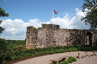
Monmouth Castle is a castle close to the centre of the town of Monmouth, the county town of Monmouthshire, on a hill above the River Monnow in south east Wales.

The Shire Hall in Agincourt Square, Monmouth, Wales, is a prominent Grade I listed building in the town centre. It was built in 1724, and was formerly the centre for the Assize Courts and Quarter Sessions for Monmouthshire. In 1839–40, the court was the location of the trial of the Chartist leader John Frost and others for high treason for their part in the Newport Rising. The building was also used as a market place. The Shire Hall is owned by Monmouthshire County Council and has audiovisual guides for visitors to Courtroom 1. It is currently used as a Tourist Information Centre and as the offices for Monmouth Town Council, and is open to the public in part.

Troy House is a Welsh historic house, on a "ducal" scale, north-east of Mitchel Troy, Monmouthshire. The original house belonged to Blanche Herbert, Lady Troy, of the Herbert family of Raglan Castle, who owned great estates in South Wales as Marquesses of Worcester and later Dukes of Beaufort. The present structure, overlooking the River Trothy was constructed from 1681 to 1684 as a wedding present for Charles Somerset by his father, Henry Somerset, 1st Duke of Beaufort. Troy House is a Grade II* listed building.

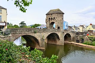
The Church of St Thomas the Martyr at Overmonnow, Monmouth, south east Wales, is located beside the medieval Monnow Bridge across the River Monnow. At least part of the building dates from around 1180, and it has a fine 12th-century Norman chancel arch, though the exterior was largely rebuilt in the early 19th century. It is one of 24 buildings on the Monmouth Heritage Trail and is a Grade II* listed building.

St Mary's Priory Church, in Whitecross Street, Monmouth, Monmouthshire, Wales, is an Anglican church founded as a Benedictine priory in 1075. The current church dates mostly from the 18th and 19th centuries. It was designated a Grade II* listed building in 1952. It is one of 24 buildings on the Monmouth Heritage Trail.

Monmouth Priory, in Priory Street, Monmouth, Wales, is a building that incorporates the remains of the monastic buildings attached to St Mary's Priory Church. The priory was a Benedictine foundation of 1075, and parts of the mediaeval buildings remain. The buildings were substantially redeveloped in the nineteenth century for use as St Mary's National School, and now form a community centre. The complex is a Grade II* listed building as of 27 June 1952. It is one of 24 sites on the Monmouth Heritage Trail.

The Market Hall, in Priory Street, Monmouth, Wales, is an early Victorian building by the prolific Monmouth architect George Vaughan Maddox. It was constructed in the years 1837–39 as the centrepiece of a redevelopment of part of Monmouth town centre. After being severely damaged by fire in 1963, it was partly rebuilt and is now the home of Monmouth Museum. At the rear of the building are original slaughterhouses, called The Shambles, opening onto the River Monnow. The building is Grade II listed as at 27 June 1952, and it is one of 24 buildings on the Monmouth Heritage Trail. The Shambles slaughterhouses are separately listed as Grade II*.
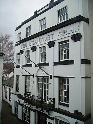
The Beaufort Arms Hotel, Agincourt Square, Monmouth, Monmouthshire, south-east Wales is a former coaching inn dating from the early eighteenth century, though the frontage may have been modified by the prolific early Victorian architect George Vaughan Maddox in the 1830s. A stone cornice on the central block still carries the inscription "The Beaufort Arms". It is a Grade II* listed building as of 27 June 1952. It is one of 24 buildings on the Monmouth Heritage Trail.

George Vaughan Maddox was a nineteenth-century British architect and builder, whose work was undertaken principally in the town of Monmouth, Wales, and in the wider county. Working mainly in a Neo-Classical style, his extensive output made a significant contribution to the Monmouth townscape. The architectural historian John Newman considers that Monmouth owes to Maddox "its particular architectural flavour. For two decades from the mid-1820s he put up a sequence of public buildings and private houses in the town, in a style deft, cultured, and only occasionally unresolved." The Market Hall and 1-6 Priory Street are considered his "most important projects".

Church Street is a pedestrianised street in the centre of Monmouth, Wales. It contains a variety of independent shops, restaurants, commercial art galleries, and the Savoy Theatre. Until the 1830s, when Priory Street was built to bypass it, it was the main thoroughfare into the centre of Monmouth from the north-east, linking the market and the parish church. It was at one time the centre of the town's butchery trade and was known as Butcher's Row.

Whitecross Street is a historic street in the town centre of Monmouth, Monmouthshire, Wales. It was in existence by the 15th century, and appears as Whit crose on the 1610 map of the town by cartographer John Speed. It runs in an east-west direction, between Church Street and St James Square. It has been suggested that the street takes its name from a plague cross. Whitecross Street is lined with numerous listed buildings.
Monk Street is an historic street in the town of Monmouth, Monmouthshire, Wales. A portion of it was in existence by the 14th century, and appears on the 1610 map of the town by cartographer John Speed. It runs in a north-south direction, extending northward from its intersection with Whitecross Street. The name of the street relates to the nearby Priory, as well as the gate which was originally on this road and provided part of the town's defences, Monk's Gate. Monk Street is lined with numerous listed buildings.
Kingsley House and Hendre House are a pair of 19th-century, semi-detached houses on the North Parade section of Monk Street in Monmouth, Monmouthshire, Wales. The grade II listed houses were designed by noted Monmouth architect and builder George Vaughan Maddox, who also designed at least two of the twenty-four blue plaque buildings on the Monmouth Heritage Trail, including the Market Hall and the Monmouth Methodist Church. Hendre House should be distinguished from The Hendre, the estate of the Rolls family.
Glendower Street is a historic street in the town centre of Monmouth, Monmouthshire, Wales. It extends to the southeast from the intersection of Agincourt Street and St John's Street, within the medieval town walls. Glendower Street is lined with numerous listed buildings, including one of the 24 blue plaque buildings on the Monmouth Heritage Trail.

The Crown and Thistle Inn was a public house in Monmouth, Monmouthshire, Wales. It was in the historic Agincourt Square neighbourhood. Prior to its conversion to a public house, the building served as the premises of an apothecary. During the early nineteenth century, the Crown and Thistle Inn briefly housed one of the earliest Masonic Lodges in Monmouthshire.
Wye Bridge Ward was one of four wards in the town of Monmouth, Monmouthshire, Wales. Streets in the ward included St Mary's Street, Almshouse Street, St James Street, St James Square, Whitecross Street and Monk Street. The ward existed as a division of the town by the early seventeenth century, and continued into the twentieth century.

1–6 Priory Street in Monmouth, Wales, is a row of six shop houses designed by the architect George Vaughan Maddox and constructed c. 1837. They form part of Maddox's redevelopment of the centre of Monmouth and stand opposite his Market Hall. The architectural historian John Newman has written that Maddox's work "gives Monmouth its particular architectural flavour," and considers Priory Street to be "his greatest work."

12–16 Church Street in Monmouth, Wales, is a row of three shop houses designed by the architect George Vaughan Maddox and constructed c. 1837. They form part of Maddox's redevelopment of the centre of Monmouth and stand on Church Street, to the rear of Maddox's Priory Street. The architectural historian John Newman has written that Maddox's work "gives Monmouth its particular architectural flavour" and Cadw describes the grouping of 12–16 Church Street as "the best preserved early 19th century shopfront in Monmouth."

Perth-hir House, Rockfield, Monmouthshire, Wales, was a major residence of the Herbert family. It stood at a bend of the River Monnow, to the north-west of the village. At its height in the 16th century, the mansion, entered by two drawbridges over a moat, comprised a great hall and a number of secondary structures. Subsequently in the ownership of the Powells, and then the Lorimers, the house became a centre of Catholic recusancy following the English Reformation. By the 19th century, the house had declined to the status of a farmhouse and it was largely demolished in around 1830. Its ruins, and the site which contains considerable remnants of a Tudor garden, are a scheduled monument.


