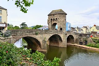
Monnow Bridge, in Monmouth, Wales, is the only remaining fortified river bridge in Great Britain with its gate tower standing on the bridge. Such bridge towers were common across Europe from medieval times, but many were destroyed due to urban expansion, diminishing defensive requirements and the increasing demands of traffic and trade. The historical and architectural importance of the bridge and its rarity are reflected in its status as a scheduled monument and a Grade I listed building. The bridge crosses the River Monnow 500 metres (1,600 ft) above its confluence with the River Wye.
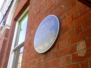
Blestium was a small fort and iron working centre in the Roman province of Britannia Superior, part of Roman Britain. It has been identified with the site of the later town of Monmouth in south east Wales, located adjoining the confluence of the River Monnow with the River Wye. A plaque on the local bank records its position.
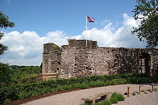
Monmouth Castle is a castle close to the centre of the town of Monmouth, the county town of Monmouthshire, on a hill above the River Monnow in south east Wales.

The Shire Hall in Agincourt Square, Monmouth, Wales, is a prominent Grade I listed building in the town centre. It was built in 1724, and was formerly the centre for the Assize Courts and Quarter Sessions for Monmouthshire. In 1839–40, the court was the location of the trial of the Chartist leader John Frost and others for high treason for their part in the Newport Rising. The building was also used as a market place. The Shire Hall is owned by Monmouthshire County Council and has audiovisual guides for visitors to Courtroom 1. It is currently used as a Tourist Information Centre and as the offices for Monmouth Town Council, and is open to the public in part.

The Church of St Thomas the Martyr at Overmonnow, Monmouth, south east Wales, is located beside the medieval Monnow Bridge across the River Monnow. At least part of the building dates from around 1180, and it has a fine 12th-century Norman chancel arch, though the exterior was largely rebuilt in the early 19th century. It is one of 24 buildings on the Monmouth Heritage Trail and is a Grade II* listed building.
The Monmouth Heritage Trail is a walking route which connects various sights in the town of Monmouth, Wales.

The Nelson Garden, on 13 Chippenhamgate Street, at the rear of No.18 Monnow Street, Monmouth, Monmouthshire is a 19th-century garden that was the scene of a tea party held to honour Lord Nelson in 1802. The garden is one of 24 sites on the Monmouth Heritage Trail. It is bounded on the south by the line of the medieval town wall through which it is entered via a short underground passageway. The garden has limited public access and is now managed by a trust. It is included on the Cadw/ICOMOS Register of Parks and Gardens of Special Historic Interest in Wales.

St Mary's Roman Catholic Church, in St Mary's Street near the centre of Monmouth, is the earliest post-Reformation Catholic public place of worship to be permitted in Wales. The church is a late Georgian Roman Catholic church with later Victorian additions by the Catholic convert architect Benjamin Bucknall. It has been designated as a Grade II listed building since 15 August 1974, and is one of 24 buildings on the Monmouth Heritage Trail.

The Market Hall, in Priory Street, Monmouth, Wales, is an early Victorian building by the prolific Monmouth architect George Vaughan Maddox. It was constructed in the years 1837–39 as the centrepiece of a redevelopment of part of Monmouth town centre. After being severely damaged by fire in 1963, it was partly rebuilt and is now the home of Monmouth Museum. At the rear of the building are original slaughterhouses, called The Shambles, opening onto the River Monnow. The building is Grade II listed as at 27 June 1952, and it is one of 24 buildings on the Monmouth Heritage Trail. The Shambles slaughterhouses are separately listed as Grade II*.

Cornwall House is a town house located at numbers 56 and 58, Monnow Street in Monmouth, Wales. It dates in part from the 17th century but was rebuilt in several stages later. The street facade and rear facade are very different, but both are reworkings of a much older building. It is a Grade II* listed building, and has been described in The Buildings of Wales as "the most imposing house in the street". Part has been the main office of the Monmouthshire Beacon newspaper since 1987.

Monnow Street is the main shopping street of Monmouth, south east Wales. It runs for about 500 yards in a south-westerly direction from Agincourt Square to the Monnow Bridge, which crosses the River Monnow.
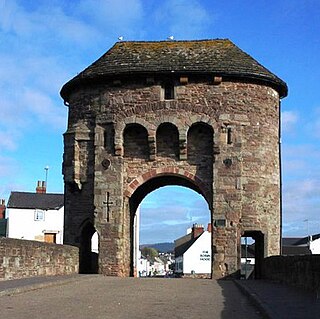
The Monmouth town walls and defences comprise the defensive system of town walls and gates built in Monmouth, Wales between 1297 and the early part of the following century. Wye Bridge Gate, East Gate, Monk's Gate, and Monnow Bridge Gate were access points to the town. West Gate, across Monnow Street, also provided access. Only the Monnow Bridge Gatehouse survives intact, albeit in a substantially modified version from the original.
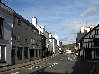
St James Street is a historic street in the town centre of Monmouth, Monmouthshire, Wales. It appears as a segment of Whitecross Street on the 1610 map of the town by cartographer John Speed and is within the medieval town walls. On more recent maps, it extends from St James Square southwest to Almshouse Street. In 2010, the street was the site of discovery of Mesolithic era artefacts. St James Street is lined with numerous listed buildings.

The Grange consists of three attached, grade II listed buildings in Monmouth, Monmouthshire, Wales. It is in the historic St James Street neighbourhood, within the medieval town walls. The Grange was originally built by Captain Charles Philipps at the site of a former farm house. It was the residence of the Kane family and, later, the Windsor family. The buildings also served as a preparatory school, one of the schools of the Haberdashers' Company, until 2009. In 2011, the buildings were converted into a boarding house for students of Monmouth School, another Haberdashers' Company school.

Glendower Street is a historic street in the town centre of Monmouth, Monmouthshire, Wales. It extends to the southeast from the intersection of Agincourt Street and St John's Street, within the medieval town walls. Glendower Street is lined with numerous listed buildings, including one of the 24 blue plaque buildings on the Monmouth Heritage Trail.
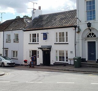
The Druid's Head Inn is a grade II listed building in the town centre of Monmouth, Monmouthshire, Wales. It is located in the historic Glendower Street and Chippenhamgate Street neighbourhood, within the medieval town walls. The building served as a public house during most of its history, but for the last several decades has been the headquarters of the Monmouth Rugby Football Club.

Monmouthshire is a county and principal area of Wales. It borders Torfaen and Newport to the west; Herefordshire and Gloucestershire to the east; and Powys to the north. The largest town is Abergavenny, with the other major towns being Chepstow, Monmouth, and Usk. The county is 850 km2 in extent, with a population of 95,200 as of 2020. The present county was formed under the Local Government (Wales) Act 1994, which came into effect in 1996, and comprises some sixty percent of the historic county. Between 1974 and 1996, the county was known by the ancient title of Gwent, recalling the medieval Welsh kingdom. In his essay on local government in the fifth and final volume of the Gwent County History, Robert McCloy suggests that the governance of "no county in the United Kingdom in the twentieth century was so transformed as that of Monmouthshire".

Monmouthshire is a county and principal area of Wales. It borders Torfaen and Newport to the west; Herefordshire and Gloucestershire to the east; and Powys to the north. The largest town is Abergavenny, with the other major towns being Chepstow, Monmouth, and Usk. The county is 850 km2 in extent, with a population of 95,200 as of 2020. The present county was formed under the Local Government (Wales) Act 1994, which came into effect in 1996, and comprises some sixty percent of the historic county. Between 1974 and 1996, the county was known by the ancient title of Gwent, recalling the medieval Welsh kingdom. In his essay on local government in the fifth and final volume of the Gwent County History, Robert McCloy suggests that the governance of "no county in the United Kingdom in the twentieth century was so transformed as that of Monmouthshire".

St Cenedlon's is a parish church in the village of Rockfield, Monmouthshire, Wales. The dedication to St Cenedlon is unusual and the history of the saint is obscure. Some sources suggest that she was a daughter of Brychan king of Brycheiniog while others identify her as the wife of King Arthfael ab Ithel, king of Glywysing. The existing church dates from the Middle Ages but only the tower remains from that period. After the English Reformation, the surrounding area of north Monmouthshire became a refuge for Catholics and Matthew Pritchard (1669-1750), Roman Catholic bishop and Vicar Apostolic of the Western District is buried at the church. By the mid-19th century the church was in ruins and a complete reconstruction was undertaken by the ecclesiastical architects John Pollard Seddon and John Prichard in around 1860. St Cenedlon's is an active parish church in the Diocese of Monmouth. It is designated by Cadw as a Grade II listed building.

The Inglis Bridge, Monmouth, Wales crosses the River Monnow linking Vauxhall Fields and the suburb of Osbaston. Designed by, and named after, Charles Inglis, the bridge was constructed in 1931 and refurbished in 1988. It is a Mark II model of an Inglis bridge, and the only known example in Britain of such a bridge still in public use. Access is now limited to pedestrians, vehicular use being prohibited in 2018 on safety grounds. The bridge is a Grade II listed structure.


