History
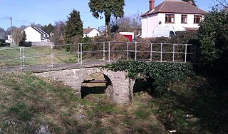
The present four-storey house, dates from the early nineteenth century and still has a weir in the Monnow, with a very short leat. The building has a slate roof and it is now used as a dwelling. After 1895 two undershot wheels, measuring 3.6 m (12 ft) and 0.9 m (3 ft) drove four pairs of millstones and rollers. [2]
The Mill was a corn mill, producing flour, for much of its existence dating back to 1448. [2] However, in the early 20th century the mill was used as a machine shop, manufacturing small parts for cars and motorcycles such as Morris Motors [3]
The Mill originally had a house and outbuildings on the opposite side of the road. These are now separate and are also private dwellings. Monnow Mill, house, mill and outbuildings were owned by the 9th Duke of Beaufort and formed part of his estate in 1901 when they were listed for auction. [2]

Monmouth is the historic county town of Monmouthshire in Wales and also a community. Situated where the River Monnow joins the River Wye, 2 miles (3.2 km) of the border with England. The town is 30 miles (48 km) northeast of Cardiff, and 113 miles (182 km) west of London. It is within the Monmouthshire local authority, and the parliamentary constituency of Monmouth. Monmouth's population in the 2011 census was 10,508, rising from 8,877 in 2001.

The River Monnow marks the England–Wales border for much of its 42 miles (68 km) length. After flowing through southwest Herefordshire, England, and eastern Monmouthshire, Wales, its confluence with the River Wye is approximately 1⁄3 mile (0.54 km) south of Monmouth.
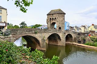
Monnow Bridge, in Monmouth, Wales, is the only remaining fortified river bridge in Great Britain with its gate tower standing on the bridge. Such bridge towers were common across Europe from medieval times, but many were destroyed due to urban expansion, diminishing defensive requirements and the increasing demands of traffic and trade. The historical and architectural importance of the bridge and its rarity are reflected in its status as a Scheduled Monument and a Grade I listed building. The bridge crosses the River Monnow 500 metres (1,600 ft) above its confluence with the River Wye.
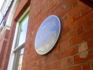
Blestium was a small fort and iron working centre in the Roman province of Britannia Superior, part of Roman Britain. It has been identified with the site of the later town of Monmouth in south east Wales, located adjoining the confluence of the River Monnow with the River Wye. A plaque on the local bank records its position.
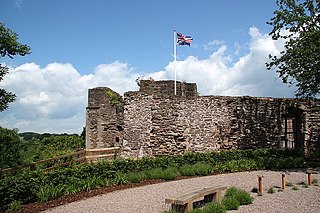
Monmouth Castle is a castle in the town of Monmouth, county town of Monmouthshire, south east Wales. It is a Grade I listed building and scheduled monument.

The Shire Hall in Agincourt Square, Monmouth, Wales, is a prominent Grade I listed building in the town centre. It was built in 1724, and was formerly the centre for the Assize Courts and Quarter Sessions for Monmouthshire. In 1839/40, the court was the location of the trial of the Chartist leader John Frost and others for high treason for their part in the Newport Rising. The building was also used as a market place. The Shire Hall is owned by Monmouthshire County Council and has audiovisual guides for visitors to Courtroom 1. It is currently used as a Tourist Information Centre and as the offices for Monmouth Town Council, and is open to the public in part.

Drybridge House is a large 17th-century Grade II* listed building in Monmouth, south east Wales. It is located to the southwest of the town at one end of Drybridge Street, close to the “dry bridge” over a small stream, which is now buried beneath a nearby roundabout. It is one of 24 buildings on the Monmouth Heritage Trail, and is now managed as the Bridges Centre.

Monmouth Priory, in Priory Street, Monmouth, Wales, is a building that incorporates the remains of the monastic buildings attached to St Mary's Priory Church. The priory was a Benedictine foundation of 1075, and parts of the mediaeval buildings remain. The buildings were substantially redeveloped in the nineteenth century for use as St Mary's National School, and now form a community centre. The complex is a Grade II* listed building as of 27 June 1952. It is one of 24 sites on the Monmouth Heritage Trail.

Cornwall House is a town house located at numbers 56 and 58, Monnow Street in Monmouth, Wales. It dates in part from the 17th century but was rebuilt in several stages later. The street facade and rear facade are very different, but both are reworkings of a much older building. It is a Grade II* listed building, and has been described in The Buildings of Wales as "the most imposing house in the street". Part has been the main office of the Monmouthshire Beacon newspaper since 1987.

Chapel House, Hereford Road, Monmouth, Wales, is a Georgian townhouse, built in the early eighteenth century, described by the architectural historian John Newman, as "the best house in the entire street". The house was designated a Grade II* listed building on 27 June 1952. Chapel House is now a boarding house of Monmouth School.

Overmonnow is that part of the town of Monmouth, in Wales, which is located to the west of the River Monnow and the Monnow Bridge. It developed as a suburb of the town in the Middle Ages, when it was protected by a defensive ditch, the Clawdd-du or "Black Dyke", the remains of which are now protected as an ancient monument. In later centuries the area became known as "Little Monmouth" or "Cappers' Town". Development of the area has continued, particularly since the mid-twentieth century, and the area is now a ward of Monmouthshire County Council.

Hilston Park is a country house and estate between the villages of Newcastle and Skenfrith in Monmouthshire, Wales, close to the border with Herefordshire, England. The house and park are in the Monnow valley, beside the B4347 road, 7.9 miles (12.7 km) by road northwest of Monmouth and just over 1 mile (1.6 km) southwest of Skenfrith.
The Clawdd-du, also known in historical records as the Black Dyke, Black Ditch or Clawthy, is a mediaeval linear defensive earthwork or moat, constructed as protection for the faubourg of Overmonnow, on the opposite side of the River Monnow from the town and castle of Monmouth, Wales.

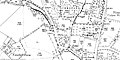
Osbaston is a suburb of Monmouth, Wales, located less than 1 mile (1.6 km) north of the town centre. It was the site of one of the first public electricity generating stations in Britain, using water power from the River Monnow.

The Monmouth New Hydro Scheme, which incorporates the Osbaston fish pass, is a hydroelectric scheme in Osbaston, near Monmouth, in South-East Wales.
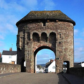
The Monmouth town walls and defences comprise the defensive system of town walls and gates built in Monmouth, Wales between 1297 and the early part of the following century. Wye Bridge Gate, East Gate, Monk's Gate, and Monnow Bridge Gate were access points to the town. West Gate, across Monnow Street, also provided access. Only the Monnow Bridge Gatehouse survives intact, albeit in a substantially modified version from the original.

Glendower Street is a historic street in the town centre of Monmouth, Monmouthshire, Wales. It extends to the southeast from the intersection of Agincourt Street and St John's Street, within the medieval town walls. Glendower Street is lined with numerous listed buildings, including one of the 24 blue plaque buildings on the Monmouth Heritage Trail.
Wye Bridge Ward was one of four wards in the town of Monmouth, Monmouthshire, Wales. Streets in the ward included St Mary's Street, Almshouse Street, St James Street, St James Square, Whitecross Street and Monk Street. The ward existed as a division of the town by the early seventeenth century, and continued into the twentieth century.

Great Manson Farm is a property on the northern outskirts of Monmouth, Monmouthshire, Wales, in the Buckholt area. It is in the Manson Lane neighbourhood, within the electoral division of Dixton with Osbaston. During the course of the nineteenth and twentieth centuries, members of the Clarke, Goode, Clark, Dampier, and Morgan families resided at Great Manson Farm, at which time the reported size of the farm varied from 170 to 200 acres. The property is remarkable for the presence of three grade II listed buildings, including a barn with medieval origins.

12–16 Church Street in Monmouth, Wales, is a row of three shop houses designed by the architect George Vaughan Maddox and constructed c. 1837. They form part of Maddox's redevelopment of the centre of Monmouth and stand on Church Street, to the rear of Maddox's Priory Street. The architectural historian John Newman has written that Maddox's work "gives Monmouth its particular architectural flavour" and Cadw describes the grouping of 12–16 Church Street as "the best preserved early 19th century shopfront in Monmouth."