Monmouth is a town and community in Wales. It is situated where the River Monnow joins the River Wye, 2 miles (3.2 km) from the Wales–England border. Monmouth is 30 miles (48 km) northeast of Cardiff, and 113 miles (182 km) west of London. It is within the Monmouthshire local authority, and the parliamentary constituency of Monmouth. The population in the 2011 census was 10,508, rising from 8,877 in 2001. Monmouth is the historic county town of Monmouthshire although Abergavenny is now the county town.
Goldcliff is a village, parish and community to the south east of the city of Newport in South Wales. It lies within the Newport city boundaries in the historic county of Monmouthshire and the preserved county of Gwent. Administratively, the community of Goldcliff includes the village/parish of Whitson. The population in 2001 was 233; by 2011 it had risen to 329.
The Monmouth Archaeological Society is a society of amateur and professional archaeologists who encourage the preservation of archaeological artifacts and sites, publish, and carry out archaeological studies in and around Monmouth, Wales.

St Mary's Priory Church, in Whitecross Street, Monmouth, Monmouthshire, Wales, is an Anglican church founded as a Benedictine priory in 1075. The current church dates mostly from the 18th and 19th centuries. It was designated a Grade II* listed building in 1952. It is one of 24 buildings on the Monmouth Heritage Trail.
There are a number of war memorials in Monmouth, Wales.
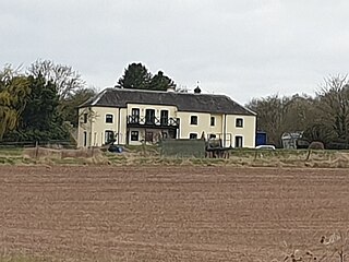
Croft-Y-Bwla is a country house and farm 1.5 miles (2.4 km) north-west of Monmouth, south-east Wales. The house was built around 1830 and was designed by the noted Monmouth architect George Vaughan Maddox. It has been listed as Grade II since 1974.
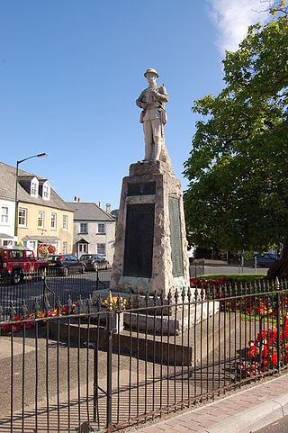
The Monmouth War Memorial commemorates the Monmouth fallen of the First and Second World Wars.
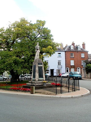
St James Square in Monmouth, Monmouthshire, Wales is the site of a historic Indian Bean Tree. The Catalpa bignonioides, a native of the southeastern United States, was planted in the square in about 1900. It was joined by the Monmouth War Memorial in 1921. After more than one hundred years of presiding over the square, the tree became the focus of controversy when it was condemned by the Monmouthshire County Council in 2005. The decision was met with fierce community opposition. The parties involved resolved their differences in 2006, and the tree received treatment, albeit some of it unauthorized. By 2011, the Indian Bean Tree in St James Square was flourishing.

The discovery of artefacts at two excavation sites in 2010 revealed human settlement at Monmouth in the Mesolithic period. The artefacts uncovered by archaeologists at St James' Square and Wyebridge Street included charcoal, flints, and bone fragments. The discovery has led to the conclusion that the site of Monmouth, adjoining the confluence of the rivers Monnow and Wye in south east Wales, was inhabited thousands of years earlier than previously believed.
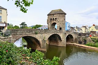
The Monmouth town walls and defences comprise the defensive system of town walls and gates built in Monmouth, Wales between 1297 and the early part of the following century. Wye Bridge Gate, East Gate, Monk's Gate, and Monnow Bridge Gate were access points to the town. West Gate, across Monnow Street, also provided access. Only the Monnow Bridge Gatehouse survives intact, albeit in a substantially modified version from the original.

Whitecross Street is a historic street in the town centre of Monmouth, Monmouthshire, Wales. It was in existence by the 15th century, and appears as Whit crose on the 1610 map of the town by cartographer John Speed. It runs in an east-west direction, between Church Street and St James Square. It has been suggested that the street takes its name from a plague cross. Whitecross Street is lined with numerous listed buildings.
Monk Street is an historic street in the town of Monmouth, Monmouthshire, Wales. A portion of it was in existence by the 14th century, and appears on the 1610 map of the town by cartographer John Speed. It runs in a north-south direction, extending northward from its intersection with Whitecross Street. The name of the street relates to the nearby Priory, as well as the gate which was originally on this road and provided part of the town's defences, Monk's Gate. Monk Street is lined with numerous listed buildings.
St James Square is a historic square in the town centre of Monmouth, Monmouthshire, Wales. It is located at the eastern end of Whitecross Street, within the medieval town walls. The area features the Monmouth War Memorial and the controversial, historic Indian Bean Tree. In addition, in 2010, the square was the site of discovery of the first Mesolithic artefacts in Monmouth. St James Square is lined with numerous listed buildings. It is also home to the Monmouth Catalpa Tree.
St James Street is a historic street in the town centre of Monmouth, Monmouthshire, Wales. It appears as a segment of Whitecross Street on the 1610 map of the town by cartographer John Speed and is within the medieval town walls. On more recent maps, it extends from St James Square southwest to Almshouse Street. In 2010, the street was the site of discovery of Mesolithic era artefacts. St James Street is lined with numerous listed buildings.

The Grange consists of three attached, grade II listed buildings in Monmouth, Monmouthshire, Wales. It is in the historic St James Street neighbourhood, within the medieval town walls. The Grange was originally built by Captain Charles Philipps at the site of a former farm house. It was the residence of the Kane family and, later, the Windsor family. The buildings also served as a preparatory school, one of the schools of the Haberdashers' Company, until 2009. In 2011, the buildings were converted into a boarding house for students of Monmouth School, another Haberdashers' Company school.

St James House is a grade II listed building in Monmouth, Monmouthshire, Wales. It is in the historic St James Square neighbourhood, within the Medieval town walls. While the house currently has an attractive, 18th-century facade, it originated as a burgage tenement. In addition, behind the house, evidence of a kiln has been unearthed, with both Medieval and Post-medieval pottery. In 2010, archaeological excavation in the square revealed the first evidence of Mesolithic human settlement in Monmouth. Recent residents of St James House have included boarding students from Monmouth School.
Glendower Street is a historic street in the town centre of Monmouth, Monmouthshire, Wales. It extends to the southeast from the intersection of Agincourt Street and St John's Street, within the medieval town walls. Glendower Street is lined with numerous listed buildings, including one of the 24 blue plaque buildings on the Monmouth Heritage Trail.

The Monmouth Police Station is a Grade II listed building in the town centre of Monmouth, Monmouthshire, Wales. It is located in Glendower Street, within the medieval town walls. In March 2012, it was announced that the Monmouth Police Station was one of seventeen police stations in South East Wales that would no longer be open to the public.

St John's is a grade II listed building in the town centre of Monmouth, Wales. It is located in Glendower Street within the medieval town walls. The house is most remarkable for the rear of the property which features a Coalbrookdale verandah and formal walled garden that have been separately grade II listed with the Cadw/ICOMOS Register of Parks and Gardens of Special Historic Interest in Wales. The villa's garden is also registered with the Welsh Historic Gardens Trust.
Wye Bridge Ward was one of four wards in the town of Monmouth, Monmouthshire, Wales. Streets in the ward included St Mary's Street, Almshouse Street, St James Street, St James Square, Whitecross Street and Monk Street. The ward existed as a division of the town by the early seventeenth century, and continued into the twentieth century.


