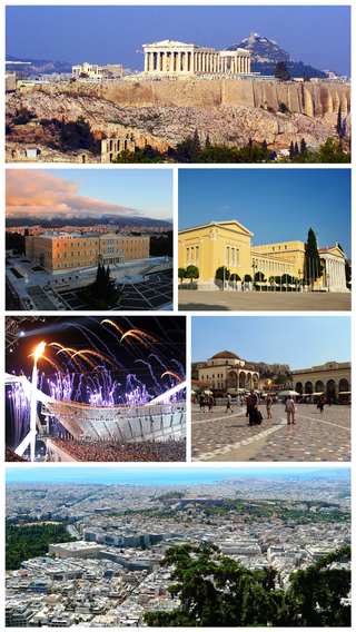
Athens is a major coastal urban area in the Mediterranean and it is both the capital and the largest city of Greece. With its urban area's population numbering over three million, it is also the eighth largest urban area in the European Union. Athens dominates and is the capital of the Attica region and is one of the world's oldest cities, with its recorded history spanning over 3,400 years, and its earliest human presence beginning somewhere between the 11th and 7th millennia BC. The city was named after a Greek war goddess.

England is a country that is part of the United Kingdom. It shares land borders with Wales to its west and Scotland to its north. The Irish Sea lies northwest and the Celtic Sea area of the Atlantic Ocean to the southwest. It is separated from continental Europe by the North Sea to the east and the English Channel to the south. The country covers five-eighths of the island of Great Britain, which lies in the North Atlantic, and includes over 100 smaller islands, such as the Isles of Scilly and the Isle of Wight.
The European Union (EU) is a supranational political and economic union of 27 member states that are located primarily in Europe. The union has a total area of 4,233,255 km2 (1,634,469 sq mi) and an estimated total population of nearly 447 million. The EU has often been described as a sui generis political entity combining the characteristics of both a federation and a confederation.
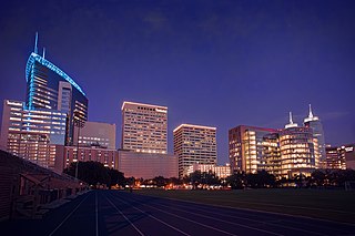
Houston is the most populous city in Texas and in the Southern United States. It is the fourth-most populous city in the United States after New York City, Los Angeles, and Chicago, and the sixth-most populous city in North America. With a population of 2,304,580 in 2020, Houston is located in Southeast Texas near Galveston Bay and the Gulf of Mexico; it is the seat and largest city of Harris County and the principal city of the Greater Houston metropolitan area, which is the fifth-most populous metropolitan statistical area in the United States and the second-most populous in Texas after Dallas–Fort Worth. Houston is the southeast anchor of the greater megaregion known as the Texas Triangle.

Maryland is a state in the Mid-Atlantic region of the United States. It borders Virginia, West Virginia, and Washington, D.C., to its south and west; Pennsylvania to its north; and Delaware and the Atlantic Ocean to its east. With a total land area of 12,407 square miles (32,130 km2), Maryland is the 8th-smallest state by land area, but its population of 6,177,224 ranks it the 18th-most populous state and the 5th-most densely populated. Baltimore is the largest city in the state, and the capital is Annapolis. The western portion of the state contains numerous stretches of the Appalachian Mountains, while the central portion is primarily composed of the Piedmont. The eastern side of the state makes up the Chesapeake Bay, sharing the border with Delaware, and the southeastern side borders the Atlantic Ocean. Among its occasional nicknames are Old Line State, the Free State, and the Chesapeake Bay State. It is named after Henrietta Maria, the French-born queen of England, Scotland, and Ireland, who was known then in England as Mary.

Mumbai is the capital city of the Indian state of Maharashtra. Mumbai is the de facto financial centre and the most populous city of India with an estimated city proper population of 12.5 million (1.25 crore). Mumbai is the centre of the Mumbai Metropolitan Region, the sixth most populous metropolitan area in the world with a population of over 23 million living under the Brihanmumbai Municipal Corporation. Mumbai lies on the Konkan coast on the west coast of India and has a deep natural harbour. In 2008, Mumbai was named an alpha world city.

Ohio, officially the State of Ohio, is a state in the Midwestern United States. Of the fifty U.S. states, it is the 34th-largest by area. With a population of nearly 11.8 million, Ohio is the seventh-most populous and tenth-most densely populated state. Its capital and largest city is Columbus, with the Columbus metro area, Greater Cincinnati, and Greater Cleveland being the largest metropolitan areas. Ohio is bordered by Lake Erie to the north, Pennsylvania to the east, West Virginia to the southeast, Kentucky to the southwest, Indiana to the west, and Michigan to the northwest. Ohio is nicknamed the "Buckeye State" after its Ohio buckeye trees, and Ohioans are also known as "Buckeyes". Its state flag is the only non-rectangular flag of all the U.S. states.

Vancouver is a major city in western Canada, located in the Lower Mainland region of British Columbia. As the most populous city in the province, the 2021 Canadian census recorded 662,248 people in the city, up from 631,486 in 2016. The Greater Vancouver area had a population of 2.6 million in 2021, making it the third-largest metropolitan area in Canada. Greater Vancouver, along with the Fraser Valley, comprises the Lower Mainland with a regional population of over 3 million. Vancouver has the highest population density in Canada, with over 5,700 people per square kilometre, and fourth highest in North America.

A tornado is a violently rotating column of air that is in contact with both the surface of the Earth and a cumulonimbus cloud or, in rare cases, the base of a cumulus cloud. It is often referred to as a twister, whirlwind or cyclone, although the word cyclone is used in meteorology to name a weather system with a low-pressure area in the center around which, from an observer looking down toward the surface of the Earth, winds blow counterclockwise in the Northern Hemisphere and clockwise in the Southern. Tornadoes come in many shapes and sizes, and they are often visible in the form of a condensation funnel originating from the base of a cumulonimbus cloud, with a cloud of rotating debris and dust beneath it. Most tornadoes have wind speeds less than 180 kilometers per hour, are about 80 meters across, and travel several kilometers before dissipating. The most extreme tornadoes can attain wind speeds of more than 480 kilometers per hour (300 mph), are more than 3 kilometers (2 mi) in diameter, and stay on the ground for more than 100 km (62 mi).

The Normandy landings were the landing operations and associated airborne operations on Tuesday, 6 June 1944 of the Allied invasion of Normandy in Operation Overlord during World War II. Codenamed Operation Neptune and often referred to as D-Day, it was the largest seaborne invasion in history. The operation began the liberation of France and laid the foundations of the Allied victory on the Western Front.
New York most commonly refers to:

An urban area, built-up area or urban agglomeration is a human settlement with a high population-density and an infrastructure of built environment.

Nigeria has 774 local government areas (LGAs), each administered by a local government council consisting of a chairman, who is the chief executive, and other elected members, who are referred to as councillors. Each LGA is further subdivided into a minimum of ten and a maximum of twenty wards. A ward is administered to by a councillor, who reports directly to the LGA chairman. The councillors fall under the legislative arm of the local government, the third tier of government in Nigeria, below the state governments and the federal government.

Montreal is the second most populous city in Canada and the most populous city in the province of Quebec. Founded in 1642 as Ville-Marie, or "City of Mary", it is named after Mount Royal, the triple-peaked hill around which the early city of Ville-Marie is built. The city is centred on the Island of Montreal, which obtained its name from the same origin as the city, and a few much smaller peripheral islands, the largest of which is Île Bizard. The city is 196 km (122 mi) east of the national capital Ottawa, and 258 km (160 mi) southwest of the provincial capital, Quebec City.

Great Britain is an island in the North Atlantic Ocean off the north-west coast of continental Europe. With an area of 209,331 km2 (80,823 sq mi), it is the largest of the British Isles, the largest European island and the ninth-largest island in the world. It is dominated by a maritime climate with narrow temperature differences between seasons. The island of Ireland, with an area 40 per cent that of Great Britain, is to the west—these islands, along with over 1,000 smaller surrounding islands and named substantial rocks, form the British Isles archipelago.
Kano State House of Assembly is the state legislature of Kano State, Nigeria. The Kano State House of Assembly is one of the arms of Kano State Government which comprises the Executives, Judiciary and the legislatives, House of Assembly are the legislatives of Kano State. The Chamber and the offices of the Members are located at Abdu Bako Secretariat in the state capital, Kano Municipal. The House of Assembly is currently under the Leadership of All Progressives Congress (APC). There have been nine different house of assemblies the very first one was inaugurated 2 October 1979 and the present one was inaugurated 7 June 2019. There are forty members of the State House of Assembly, that represent forty-four local government areas in Kano State.
Rano is a Local Government Area and headquarters of Rano Emirate council in Kano State, Nigeria. Rano is a local government area in Kano State with administrative headquarters in the town of Rano. Rano local government area is a Hausa-Fulani community in the southern senatorial district of Kano State otherwise known as Kano South Senatorial District alongside Albasu, Bebeji, Bunkure, Doguwa, Gaya, Kiru, Takai, Ajingi, Rogo, Kibiya, Tudun Wada, Garko, Wudil and Sumaila local government areas. Rano local government area also forms a federal constituency alongside Bunkure and Kibiya local government areas. It has an area of 520 km2 and a population of 145,439 at the 2006 census. The local government area is bounded to the north by Garun Mallam and Bunkure local government areas, to the east by Kibiya local government area, to the south by Tudun Wada local government area, and to the west by Bebeji local government area. The Rano local government council is in charge of public administration in Rano local government area. The council is led by a chairman who is the executive head of the local government. The Rano legislative council make laws governing Rano local government area. It consists of 10 Councillors representing the 10 wards of the local government area.

Usman Umar Kibiyamni is the Sarkin Kibiya of Kibiya Local Government Area of Kano State. He was turbaned on 26 May 2007 following the death of Late Sarkin Kibiya Alh Ado Abdullahi Kibiya.
Joseph Albasu Kunini, RT. HON is a Nigerian politician who was the former Speaker of the Taraba State House of Assembly in the 9th Assembly.


