
The Kura is an east-flowing river south of the Greater Caucasus Mountains which drains the southern slopes of the Greater Caucasus east into the Caspian Sea. It also drains the north side of the Lesser Caucasus while its main tributary, the Aras, drains the south side of those mountains. Starting in northeastern Turkey, it flows through Turkey to Georgia, then to Azerbaijan, where it receives the Aras as a right tributary, and enters the Caspian Sea at Neftçala. The total length of the river is 1,515 kilometres (941 mi).

The Aras is a river in the Caucasus. It rises in eastern Turkey and flows along the borders between Turkey and Armenia, between Turkey and the Nakhchivan exclave of Azerbaijan, between Iran and both Azerbaijan and Armenia, and, finally, through Azerbaijan where it flows into the Kura river. It drains the south side of the Lesser Caucasus Mountains while the Kura drains the north side of the Lesser Caucasus. The river's total length is 1,072 km (666 mi) and its watershed covers an area of 102,000 km2 (39,000 sq mi). The Aras is one of the longest rivers in the Caucasus.
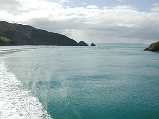
Tory Channel is one of the drowned valleys that form the Marlborough Sounds in New Zealand. Inter-island ferries normally use it as the principal channel between Cook Strait and the Marlborough Sounds.

The Kura–Araxes culture, also named Kur–Araz culture, Mtkvar-Araxes culture or the Early Transcaucasian culture was a civilization that existed from about 4000 BC until about 2000 BC, which has traditionally been regarded as the date of its end; in some locations it may have disappeared as early as 2600 or 2700 BC. The earliest evidence for this culture is found on the Ararat plain; it spread north in the Caucasus by 3000 BC.

Murupara is a town located in the Whakatāne District and Bay of Plenty Region of New Zealand's North Island. The town is situated in an isolated part of the region between the Kaingaroa Forest and Te Urewera protected area, on the banks of the Rangitaiki River, 65 kilometres southeast of Rotorua. Indigenous Māori also make up over 90% of the total population.

The Trialeti-Vanadzor culture, previously known as the Trialeti-Kirovakan culture, is named after the Trialeti region of Georgia and the city of Vanadzor, Armenia. It is attributed to the late 3rd and early 2nd millennium BC. Trialeti-Vanadzor culture emerged in the areas of the preceding Kura-Araxes culture. Some scholars speculate that it was an Indo-European culture. It developed into the Lchashen-Metsamor culture. It may have also given rise to the Hayasa-Azzi confederation mentioned in Hittite texts, and the Mushki mentioned by the Assyrians.

Matauri Bay is a bay in New Zealand, situated 30 km north of Kerikeri, in Whangaroa county, just north of the Bay of Islands. It has over a kilometre of white sand and crystal clear water, making it a popular summer destinations for surfers, divers, fishers and holidaymakers.

Spreydon is a suburb of Christchurch, New Zealand, 4 kilometres (2.5 mi) south-south-west of Cathedral Square. The most central street through Spreydon is Barrington Street. Spreydon is flanked by the suburbs Hoon Hay, Sydenham, and Lower Cashmere. State Highway 76 marks the northern boundary of the suburb, including the eastern end of the Christchurch Southern Motorway.

The water bodies of Azerbaijan were formed over a long geological timeframe and changed significantly throughout that period. This is particularly evidenced by remnants of ancient rivers found throughout the country. The country's water systems are continually changing under the influence of natural forces and human introduced industrial activities. Artificial rivers (canals) and ponds are a part of Azerbaijan's water systems.

Utik was a historic province of the Kingdom of Armenia. It was ceded to Caucasian Albania following the partition of Armenia between Sassanid Persia and the Eastern Roman Empire in 387 AD. Most of the region is located within present-day Azerbaijan immediately west of the Kura River, while a part of it lies within the Tavush province of present-day northeastern Armenia.
Klyuchi Air Base is in Kamchatka Krai, Russia located 3 kilometers (1.9 mi) southwest of the settlement of Klyuchi. It is a small but significant interceptor airfield covering northern Kamchatka, probably to defend international borders during nearby missile testing operations at Kura Missile Test Range 130 km to the northeast. Klyuchi contains about twelve fighter revetments and some narrow tarmac space.

Whangape Harbour is a harbour on the west coast of Northland, New Zealand. There is a settlement called Whangape on the northern side of the harbour. Another, called Pawarenga, is located on the southern side. Kaitaia is 42 km north east.
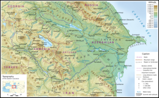
The Kura-Aras Lowland, Kura-Aras Depression or Kura-Aras Basin is a vast depression in central-southern Azerbaijan defined by the valleys of the Kura River and Aras River. It is situated by the West shore of the Caspian Sea and is part of the Aral-Caspian Depression. It is delimited by the Greater Caucasus from the North, Lesser Caucasus from the West and the Talysh Mountains from the South. The name is derived from the names of the two rivers in the area: the Kura and the Aras.

Kura kaupapa Māori are Māori-language immersion schools in New Zealand, where the philosophy and practice reflect Māori cultural values with the aim of revitalising Māori language, knowledge and culture. Kura kaupapa Māori are established under the Education Act (1989). The term kaupapa Māori is used by Māori to mean any particular plan of action created by Māori to express Māori aspirations, values and principles.
Sarysu is the largest lake of Azerbaijan located in Imishli and Sabirabad raions of the Kur-Araz Lowland.
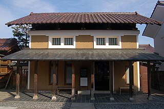
Kura are traditional Japanese storehouses. They are commonly durable buildings built from timber, stone or clay used to safely store valuable commodities.

Kura Sushi is a Japanese sushi restaurant chain. Its headquarters are in Sakai, Osaka Prefecture.

Kura or Kurkosa, also known as Kurinskiy in the Russian language, is the largest island of Azerbaijan. It lies in the Caspian Sea, off the coast of the Aran Region, 33 kilometers (21 mi) to the south of Neftchala and about 150 kilometers (93 mi) to the SSE of Baku.
Kura was a god worshiped in Ebla in the third millennium BCE. He was the tutelary god of the city, as well as the head of the local pantheon. While his functions are difficult to ascertain, it is well attested that he was connected to the institution of kingship.


