
Kano is a city in northern Nigeria and the capital of Kano State. It is the second largest city in Nigeria after Lagos, with over ten million citizens living within 449 km2 (173 sq mi). Located in the Savanna, south of the Sahel, Kano is a major route of the trans-Saharan trade, having been a trade and human settlement for millennia. It is the traditional state of the Dabo dynasty who have ruled as emirs over the city-state since the 19th century. Kano Emirate Council is the current traditional institution inside the city boundaries of Kano, and under the authority of the Government of Kano State.

Kano State is one of the 36 states of Nigeria, located in the northern region of the country. According to the national census done in 2006, Kano State is the most populous state in Nigeria. The recent official estimates taken in 2016 by the National Bureau of Statistics found that Kano State was still the largest state by population in Nigeria. Created in 1967 out of the former Northern Region, Kano State borders with Katsina State to the northwest, Jigawa State to the northeast, Bauchi State to the southeast for 131 km, and Kaduna State to the southwest for 255 km. The state's capital and largest city is the city of Kano, the second most populous city in Nigeria after Lagos. The incumbent governor of the state is Abba Kabir Yusuf. He was sworn in on 29 May 2023.
Jigawa State is one of the 36 states of Nigeria, located in the northern region of the country. Created on August 27, 1991, under the General Ibrahim Babangida who announced the creation of nine additional states in the country bringing the total number of states then to thirty. The announcement was given a legal backing through the; State Creation and Transitional Provisions Decree No. 37 of 1991. Jigawa State was a part of Kano State and was located in the northeastern-most region of Kano State, and it forms part of Nigeria's national border with the Republic of the Niger. The state capital and largest city is Dutse. Jigawa state has 27 local governments
Bebeji is a Local Government Area in Kano State, Nigeria. Its headquarters are in the town of Bebeji.
Dala is a densely populated Local Government Area in Kano State, Nigeria within Kano city created in May, 1989 from the old Kano Municipal Local Government. It is located in the north-west part of the Kano metropolis. Its headquarter is in Gwammaja.
Ungogo is a Local Government Area in Kano State, Nigeria. Its Secretariat are in the town of Ungogo to the north of the city of Kano.
Gaya is a Local Government Area in Kano State, Nigeria. Its headquarters are in the town of Gaya in the north of the area.
Danbatta is a Local Government Area in Kano State, Nigeria. It is located about 49 miles north of Kano city at the Northern border of Kano state with Jigawa state. It has headquarters at Danbatta town, located on the A2 highway.
Minjibir is a Local Government Area in Kano State, Nigeria. Its headquarters are in the town of Minjibir, about 20 km northeast of the state capital Kano.
Karaye is a Local Government Area and Headquarter of Karaye Emirate Council in Kano State, Nigeria. Its headquarters are in the town of Karaye.
Bagwai is a local government area in Kano State, Nigeria. Its headquarters is in the town of Bagwai.
Rimin Gado is a Local Government Area in Kano State, Nigeria. Its headquarters are in the town of Rimin Gado about 20 km west of the state capital Kano.
Fagge is a Local Government Area in Kano State, Nigeria, within the state metropolitan. Its headquarters are in the suburb of Waje.
Gwale is a Local Government Area in Kano State, Nigeria within Greater population and surface area at the center of the Kano city. Its headquarters are in the suburb of Gwale around the Kofar Na’isa Area.

Nassarawa is a Local Government Area in Kano State, Nigeria. Its headquarters are in the locality of Bompai, within the city of Kano.
Rano is a Local Government Area and headquarters of Rano Emirate council in Kano State, Nigeria. Rano is a local government area in Kano State with administrative headquarters in the town of Rano. Rano local government area is a Hausa-Fulani community in the southern senatorial district of Kano State otherwise known as Kano South Senatorial District alongside Albasu, Bebeji, Bunkure, Doguwa, Gaya, Kiru, Takai, Ajingi, Rogo, Kibiya, Tudun Wada, Garko, Wudil and Sumaila local government areas. Rano local government area also forms a federal constituency alongside Bunkure and Kibiya local government areas. It has an area of 520 km2 and a population of 145,439 at the 2006 census. The local government area is bounded to the north by Garun Mallam and Bunkure local government areas, to the east by Kibiya local government area, to the south by Tudun Wada local government area, and to the west by Bebeji local government area. The Rano local government council is in charge of public administration in Rano local government area. The council is led by a chairman who is the executive head of the local government. The Rano legislative council make laws governing Rano local government area. It consists of 10 Councillors representing the 10 wards of the local government area.
Takai is a Local Government Area in Kano State, Nigeria. Its headquarters are in the town of Takai to the north of the area on the A237 highway.
Dawakin Kudu is a Local Government Area in Kano State, Nigeria. Its headquarters are in the town of Dawakin Kudu.99% of inhabitants are Hausa people.
Kabiru Ibrahim Gaya is a Nigerian politician who has served in the Senate of Nigeria since 2007 representing the Kano South constituency of Kano State. He is a member of the ruling All Progressive Congress (APC).
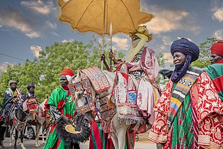
The Sultanate of Kano was a Hausa kingdom in the north of what is now Nigeria that dates back to 1349, when the king of Kano, Ali Yaji (1349–1385), dissolved the cult of Tsumbubra and proclaimed Kano a sultanate. Before 1000 AD, Kano had been ruled as an Animist Hausa Kingdom, the Kingdom of Kano. The sultanate lasted until the Fulani Jihad in 1805 and the assassination of the last sultan of Kano in 1807. The sultanate was then replaced by the Kano Emirate, subject to the Sokoto Caliphate. The capital is now the modern city of Kano in Kano State.


