Victoria Island is a large island in the Canadian Arctic Archipelago that straddles the boundary between Nunavut and the Northwest Territories of Canada. It is the eighth largest island in the world, and at 217,291 km2 (83,897 sq mi) in area, it is Canada's second largest island. It is nearly double the size of Newfoundland (111,390 km2 [43,008 sq mi]), and is slightly larger than the island of Great Britain (209,331 km2 [80,823 sq mi]) but smaller than Honshu (225,800 km2 [87,182 sq mi]). It contains the world's largest island within an island within an island. The western third of the island belongs to the Inuvik Region in the Northwest Territories; the remainder is part of Nunavut's Kitikmeot Region.

Melville Peninsula is a large peninsula in the Canadian Arctic north of Hudson Bay. To the east is Foxe Basin and to the west the Gulf of Boothia. To the north the Fury and Hecla Strait separates it from Baffin Island. To the south Repulse Bay and Frozen Strait separate it from Southampton Island at the north end of Hudson Bay. On the southwest it is connected to the mainland by the "Rae Isthmus" named after arctic explorer Dr John Rae.
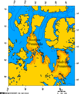
Boothia Peninsula is a large peninsula in Nunavut's northern Canadian Arctic, south of Somerset Island. The northern part, Murchison Promontory, is the northernmost point of mainland Canada.
The Hall Peninsula is a peninsula on the southern end of Baffin Island, in Nunavut, Canada. It lies between Frobisher Bay on the west, and the Cumberland Sound on the east between 62°40'N and 65°10'W. The Hall Peninsula is part of the Arctic Tundra biome—the world's coldest and driest biome. The Blunt Peninsula extends off the southeastern part of the Hall Peninsula.

Bache Peninsula is a geological formation in Canada, on Ellesmere Island in Nunavut. The peninsula is considered a cape, meaning that it is a headland that dramatically affects the ocean currents. It is primarily known for being the site of the world's northernmost permanent settlement from 1926 to 1933, a Royal Canadian Mounted Police post.

The Ottawa Islands are a group of uninhabited islands situated in the eastern edge of Canada's Hudson Bay. The group comprises 24 small islands, located at approximately 60N 80W. The main islands include Booth Island, Bronson Island, Eddy Island, Gilmour Island, J. Gordon Island, Pattee Island, and Perley Island. The highest point is on Gilmour Island, which rises to over 1,800 ft (550 m). Located a short distance off the northwest coast of Quebec's Ungava Peninsula, they, like the other coastal islands in Hudson Bay, were historically part of the Northwest Territories, and became part of the territory of Nunavut upon its creation in 1999.

Mount Odin is a mountain in Qikiqtaaluk, Nunavut, Canada. It is located in Auyuittuq National Park along the Akshayuk Pass, 46 km (29 mi) north of Pangnirtung and south of Mount Asgard. Mount Odin is the highest mountain on Baffin Island.

Cape Fullerton is a cape and peninsula in the Kivalliq Region of Nunavut, Canada located on the northwest shores of Hudson Bay on Roes Welcome Sound and includes Fullerton Harbour. Today it is part of Ukkusiksalik National Park. Although Cape Fullerton was traditionally home to migrant Inuit people including the Aivilingmiut and the Qaernermiut, today the nearest permanently populated settlement is Chesterfield Inlet, roughly 100 kilometers to the southwest.
Norman Lockyer Island is located off the eastern coast of Ellesmere Island, and a part of the Qikiqtaaluk Region of the Canadian territory of Nunavut. Situated in Princess Marie Bay just in front of Franklin Pierce Bay, north of Bache Peninsula, Norman Lockyer Island is within the Canadian Arctic Archipelago, a member of the Queen Elizabeth Islands.
The Barrow Peninsula is located on southern Baffin Island in the Canadian territory of Nunavut. It is a part of the larger Hall Peninsula. Barrow Peninsula is bounded by Frobisher Bay to the west, and Newton Fiord to the east. Hamlen Bay is in the south. The highest elevation point is 318 m (1,043 ft) above sea level.
The Becher Peninsula is located on southern Baffin Island in the Canadian territory of Nunavut. It is a part of the larger Hall Peninsula. Becher Peninsula is bounded by Frobisher Bay to the west, and Ward Inlet to the east.
The Beekman Peninsula is located on southern Baffin Island in the Canadian territory of Nunavut. It's an arm of the larger Hall Peninsula. Beekman Peninsula juts into the Labrador Sea, and is surrounded by the Smith Channel, Cornelius Grinnell Bay, Robinson Sound, and Anderson Channel.

Apex is a small community in Iqaluit located on Baffin Island in Nunavut, Canada. It is about 5 km (3.1 mi) southeast of Iqaluit on a small peninsula separating Koojesse (Kuujussi) Inlet from Tarr Inlet. Historically Apex was the place where most Inuit lived when Iqaluit was a military site and off-limits to anyone not working at the base. The community is accessed by bridge or causeway, and bordered by a local creek (kuujuusi) and waterfall (kugluktuk). Located here are the women's shelter, a church, Nanook Elementary School, and a bed-and-breakfast, along with housing for about 60 families.
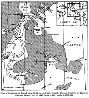
The Foxe Channel is an area of sea in Qikiqtaaluk Region, Nunavut, Canada. It separates the Foxe Basin from Hudson Bay and the Hudson Strait. To the west and south-west is Southampton Island, to the east is Baffin Island, and to the north-west is the Melville Peninsula.
Evans Strait is a natural waterway through the central Canadian Arctic Archipelago in the territory of Nunavut. It separates Southampton Island's Bell Peninsula from Coats Island.
Ulvingen Island is one of the uninhabited islands in Qikiqtaaluk Region, Nunavut, Canada. It is located in Norwegian Bay between Axel Heiberg Island and Ellesmere Island's Raanes Peninsula. It is a member of the Sverdrup Islands, Queen Elizabeth Islands, and the Canadian Arctic Archipelago. Hare Point is situated at the island's southern tip.
Rymer Point is a cape in the Canadian Arctic territory of Nunavut. It is located on southwestern Victoria Island's Wollaston Peninsula, facing the Dolphin and Union Strait. Clouston Bay is situated along the north shoreline. Nuvuk Point is on the southwest side, jutting into Simpson Bay.
Sam Ford Fiord is an isolated, elongated Arctic fjord on Baffin Island's northeastern coast in the Qikiqtaaluk Region of Nunavut, Canada. The Inuit settlement of Pond Inlet is 320 km (200 mi) to the northwest and Clyde River is 80 km (50 mi) to the east.