Related Research Articles

Hudson Strait in Nunavut links the Atlantic Ocean and the Labrador Sea to Hudson Bay in Canada. This strait lies between Baffin Island and Nunavik, with its eastern entrance marked by Cape Chidley in Newfoundland and Labrador and Nunavut and Resolution Island, off Baffin Island. The strait is about 750 km (470 mi) long with an average width of 125 km (78 mi), varying from 70 km (43 mi) at the eastern entrance to 240 km (150 mi) at Deception Bay.

The Arctic Archipelago, also known as the Canadian Arctic Archipelago, is an archipelago lying to the north of the Canadian continental mainland, excluding Greenland and Iceland.

Baffin Bay, located between Baffin Island and the west coast of Greenland, is defined by the International Hydrographic Organization as a marginal sea of the Arctic Ocean. It is sometimes considered a sea of the North Atlantic Ocean. It is connected to the Atlantic via Davis Strait and the Labrador Sea. The narrower Nares Strait connects Baffin Bay with the Arctic Ocean. The bay is not navigable most of the year because of the ice cover and high density of floating ice and icebergs in the open areas. However, a polynya of about 80,000 km2 (31,000 sq mi), known as the North Water, opens in summer on the north near Smith Sound. Most of the aquatic life of the bay is concentrated near that region.

The Labrador Sea is an arm of the North Atlantic Ocean between the Labrador Peninsula and Greenland. The sea is flanked by continental shelves to the southwest, northwest, and northeast. It connects to the north with Baffin Bay through the Davis Strait. It is a marginal sea of the Atlantic.
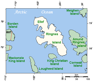
Ellef Ringnes Island is an uninhabited island and one of the Sverdrup Islands in the Qikiqtaaluk Region, Nunavut, Canada. A member of the Queen Elizabeth Islands and Arctic Archipelago, it is located in the Arctic Ocean, east of Borden Island, and west of Amund Ringnes Island. It has an area of 11,295 km2 (4,361 sq mi), making it the 69th largest island in the world and Canada's 16th largest island. Its highest mount is 260 m (850 ft).
The C family was Mazda's first large piston engine design. It is not certain whether Mazda has a name for this collection of engines, and it is uncertain precisely which ones are related.

Sverre Helge Hassel was a Norwegian polar explorer and one of the first five people to reach the South Pole.

Hamilton Township is a rural township located in Northumberland County in central Ontario. It surrounds the Town of Cobourg.

CKLY-FM is a Canadian radio station, broadcasting at 91.9 FM in Lindsay, Ontario. The station broadcasts an adult hits format branded as Bounce 91.9.

Area codes 204, 431, and 584 are telephone area codes in the North American Numbering Plan (NANP) for the Canadian province of Manitoba. Area code 204 is one of the nine original North American area codes assigned to Canada in 1947. Area codes 431 and 584 were assigned to the same numbering plan area (NPA) in 2012 and 2022, respectively, forming an overlay complex.
St. Bride's is a town on the Cape Shore of Newfoundland, Canada. Located 166 km Southwest of the capital of Newfoundland and Labrador, St. John's, St. Bride's is a fishing community with a population of approximately 318 persons as of 2021. The largest codfish ever caught, weighing in at 125 lbs, was landed here in 1905.

Franklin is a borough in Cambria County, Pennsylvania, United States. It is part of the Johnstown, Pennsylvania Metropolitan Statistical Area. At the 2010 census the borough population was 323, down from 442 at the 2000 census.

Cape Fullerton is a cape and peninsula in the Kivalliq Region of Nunavut, Canada, located on the northwest shores of Hudson Bay on Roes Welcome Sound and includes Fullerton Harbour. Today it is part of Ukkusiksalik National Park. Although Cape Fullerton was traditionally home to migrant Inuit including the Aivilingmiut and the Qaernermiut, today the nearest permanently populated settlement is Chesterfield Inlet, roughly 100 km (62 mi) to the southwest.
Cape Southwest is a headland in Qikiqtaaluk Region, Nunavut, Canada. It is located on Amund Ringnes Island near Cape Ludwig, where Norwegian Bay enters Massey Sound. Cape Maundy Thursday is to the northwest.
Cape Maundy Thursday is an ice-capped headland in Qikiqtaaluk Region, Nunavut, Canada. It is located on Amund Ringnes Island 21 miles (34 km) northwest of Cape Southwest. Cape Maundy Thursday rises to 845 metres (2,772 ft) above sea level.
Skrugar Point is a peninsula in Qikiqtaaluk Region, Nunavut, Canada. It is located on Amund Ringnes Island 40 miles (64 km) northwest of Cape Southwest. It rises to 290 metres (950 ft) above sea level and forms an entrance point to Sand Bay.
Cape Levvel is a peninsula in Qikiqtaaluk Region, Nunavut, Canada. It is located on Amund Ringnes Island by Strand Bay. From steep cliffs, it rises to 120 metres (390 ft) above sea level.
Cape Cairo is a peninsula in Qikiqtaaluk Region, Nunavut, Canada. It is located on eastern Ellef Ringnes Island.
The 1947 Assam earthquake occurred on 29 July at 13:43 UTC with an Mw of 7.3 and a maximum EMS-98 intensity of V (Strong).
Division No. 1, Subdivision U is an unorganized subdivision on the Avalon Peninsula in Newfoundland and Labrador, Canada, in Division 1. It contains the unincorporated communities of Admiral's Cove, Bauline East, Bauline South, Burnt Cove, Devils Kitchen, Flat Rock, St. Michaels and Seal Cove.
References
- Atlas of Canada
- ↑ Mills, William J. (2003). Exploring polar frontiers: a historical encyclopedia. ABC-CLIO. pp. 12–. ISBN 978-1-57607-422-0 . Retrieved 8 September 2011.