Related Research Articles

The Gulf of St. Lawrence fringes the shores of the provinces of Quebec, New Brunswick, Nova Scotia, Prince Edward Island, Newfoundland and Labrador, in Canada, plus the islands Saint-Pierre and Miquelon, possessions of France, in North America.

The Arctic Archipelago, also known as the Canadian Arctic Archipelago, is an archipelago lying to the north of the Canadian continental mainland, excluding Greenland and Iceland.

The Labrador Sea is an arm of the North Atlantic Ocean between the Labrador Peninsula and Greenland. The sea is flanked by continental shelves to the southwest, northwest, and northeast. It connects to the north with Baffin Bay through the Davis Strait. It is a marginal sea of the Atlantic.
Skelton Glacier is a large glacier flowing from the polar plateau into the Ross Ice Shelf at Skelton Inlet on the Hillary Coast, south of Victoria Land, Antarctica.
KTBT is a Top 40 (CHR) radio station, serving the Tulsa area. The iHeartMedia outlet broadcasts with an ERP of 27 kW and is licensed to Broken Arrow, Oklahoma. The station can be heard as far north as southeast Kansas. Its studios are located at the Tulsa Event Center in Southeast Tulsa and its transmitter site is near Lookout Mountain in southwest Tulsa.
Bishop River Provincial Park is a provincial park in the Pacific Ranges of the Coast Mountains on the Mainland of British Columbia, Canada, located southwest of and adjoining Ts'yl-os Provincial Park."Bishop River Park". BC Geographical Names. It lies along the upper course of the Bishop River, the main tributary of the Southgate River, from the Bishop's source at the western side of the Lillooet Icecap to midway along its course above its confluence with the Southgate. The park is 19,947 ha. in size. There are no roads or trails in the park although a forest service road from Waddington Harbour at the head of Bute Inlet leads up the Southgate to within a few miles of the park boundary.
Pedro Bank is a large bank of sand and coral, partially covered with seagrass, about 80 km south and southwest of Jamaica, rising steeply from a seabed of 800 metres depth. It slopes gently from the Pedro Cays to the west and north with depths from 13 to 30 metres. The total area of the bank within the 100-metre (328-foot) isobath measures 8,040 square kilometres. The area of a depth to 40 metres is triangular, 70 kilometres long east-west, and 43 kilometres wide. 2,400 square kilometres are less than 20 metres deep. With its islets, cays and rocks, a total land area of 270,000 m2 (2,906,256 sq ft), it is the location of one of the two offshore island groups of Jamaica, the other one being the Morant Cays. The bank is centered at 17°06′N78°20′W.

Dustin Island is an island about 18 nautical miles long, lying 15 nautical miles southeast of Cape Annawan, Thurston Island. The island forms the southeast limit of Seraph Bay.
The Rockefeller Mountains are a group of low-lying, scattered granite peaks and ridges, almost entirely snow-covered, standing 30 nautical miles south-southwest of the Alexandra Mountains on the Edward VII Peninsula of Antarctica.
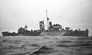
HMCS Kenogami was a Royal Canadian Navy Flower-class corvette that served during the Second World War. The corvette served primarily in convoy escort duties during the Battle of the Atlantic. Following the war, the ship was sold for scrap and broken up.
The Mulock Glacier is a large, heavily crevassed glacier which flows into the Ross Ice Shelf 40 kilometers south of the Skelton Glacier in the Ross Dependency, Antarctica.

The borders of the oceans are the limits of Earth's oceanic waters. The definition and number of oceans can vary depending on the adopted criteria. The principal divisions of the five oceans are the Pacific Ocean, Atlantic Ocean, Indian Ocean, Southern (Antarctic) Ocean, and Arctic Ocean. Smaller regions of the oceans are called seas, gulfs, bays, straits, and other terms. Geologically, an ocean is an area of oceanic crust covered by water.
The Denton Hills are a group of rugged foothills, 24 nautical miles long southwest–northeast and 9 nautical miles wide, to the east of the Royal Society Range on the Scott Coast, Victoria Land, Antarctica.
Ford Massif is a broad, snow-topped massif 15 nautical miles long and 5 nautical miles wide, forming the major topographic landmark of the northern Thiel Mountains in Antarctica. The massif rises to 2,810 metres (9,220 ft), is essentially flat, and terminates in steep rock cliffs in all but the southern side.

Garwood Valley is a valley opening on the coast of Victoria Land, Antarctica, just south of Cape Chocolate. It is one of the McMurdo Dry Valleys. It is largely ice-free, but is occupied near its head by Garwood Glacier. It was named by Thomas Griffith Taylor of the British Antarctic Expedition, 1910–13 (BrAE), in association with Garwood Glacier.
Cape Ludwig is a peninsula in Qikiqtaaluk Region, Nunavut, Canada. It is located on Amund Ringnes Island. Massey Sound is nearby, entered from Norwegian Bay between Cape Ludwig and Cape Southwest. Hendriksen Strait is to the southwest.
Cape Maundy Thursday is an ice-capped headland in Qikiqtaaluk Region, Nunavut, Canada. It is located on Amund Ringnes Island 21 miles (34 km) northwest of Cape Southwest. Cape Maundy Thursday rises to 845 metres (2,772 ft) above sea level.
Skrugar Point is a peninsula in Qikiqtaaluk Region, Nunavut, Canada. It is located on Amund Ringnes Island 40 miles (64 km) northwest of Cape Southwest. It rises to 290 metres (950 ft) above sea level and forms an entrance point to Sand Bay.
Cape Levvel is a peninsula in Qikiqtaaluk Region, Nunavut, Canada. It is located on Amund Ringnes Island by Strand Bay. From steep cliffs, it rises to 120 metres (390 ft) above sea level.
Division No. 1, Subdivision U is an unorganized subdivision on the Avalon Peninsula in Newfoundland and Labrador, Canada, in Division 1. It contains the unincorporated communities of Admiral's Cove, Bauline East, Bauline South, Burnt Cove, Devils Kitchen, Flat Rock, St. Michaels and Seal Cove.
References
- Atlas of Canada
- ↑ Dodd, G. J.; Benson, G. P.; Watts, D. T. (1976). Arctic pilot. Great Britain. Hydrographic Dept. Hydrographer of the Navy. p. 445. Retrieved 7 September 2011.