Cape Aston

Last updated

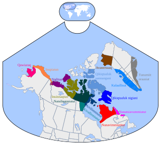
Cape Aston (Inuktitut: Niaqonaujang) [1] is a large peninsula on eastern Baffin Island, Qikiqtaaluk Region, Nunavut, Canada. Located on Baffin Bay just south of Clyde Inlet, [2] the closest settlement is Clyde River. The cape includes an ice-derived delta. [3]

Inuktitut name of some Inuit languages spoken in Canada

Inuktitut, also Eastern Canadian Inuktitut, is one of the principal Inuit languages of Canada. It is spoken in all areas north of the tree line, including parts of the provinces of Newfoundland and Labrador, Quebec, to some extent in northeastern Manitoba as well as the Northwest Territories and Nunavut. It is one of the aboriginal languages written with Canadian Aboriginal syllabics.

Peninsula A piece of land that is bordered by water on three sides but connected to mainland

A peninsula is a landform surrounded by water on the majority of its border while being connected to a mainland from which it extends. The surrounding water is usually understood to be continuous, though not necessarily named as a single body of water. Peninsulas are not always named as such; one can also be a headland, cape, island promontory, bill, point, or spit. A point is generally considered a tapering piece of land projecting into a body of water that is less prominent than a cape. A river which courses through a very tight meander is also sometimes said to form a "peninsula" within the loop of water. In English, the plural versions of peninsula are peninsulas and, less commonly, peninsulae.

Baffin Island mostly Arctic island in Nunavut, Canada

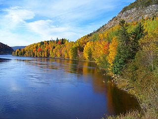
Baffin Island, in the Canadian territory of Nunavut, is the largest island in Canada and the fifth-largest island in the world. Its area is 507,451 km2 (195,928 sq mi) and its population is about 11,000. It is located in the region of 70° N and 75° W.

Cape Aston has the smallest distance to Greenland in the Baffin Bay, some 340 km, and is most likely the first location on the North American Continent, sighted by a European, namely Norse Leiv Eirikson in about year 1003.

Greenland autonomous country within the Kingdom of Denmark

Greenland is an autonomous constituent country of the Kingdom of Denmark between the Arctic and Atlantic oceans, east of the Canadian Arctic Archipelago. Though physiographically a part of the continent of North America, Greenland has been politically and culturally associated with Europe for more than a millennium. The majority of its residents are Inuit, whose ancestors began migrating from the Canadian mainland in the 13th century, gradually settling across the island.

Baffin Bay A marginal sea between Greenland and Baffin Island, Canada

Baffin Bay, located between Baffin Island and the west coast of Greenland, is a marginal sea of the North Atlantic Ocean. It is connected to the Atlantic via Davis Strait and the Labrador Sea. The narrower Nares Strait connects Baffin Bay with the Arctic Ocean. The bay is not navigable most of the year because of the ice cover and high density of floating ice and icebergs in the open areas. However, a polynya of about 80,000 km2 (31,000 sq mi), known as the North Water, opens in summer on the north near Smith Sound. Most of the aquatic life of the bay is concentrated near that region.

North America Continent entirely within the Northern Hemisphere and almost all within the Western Hemisphere

North America is a continent entirely within the Northern Hemisphere and almost all within the Western Hemisphere; it is also considered by some to be a northern subcontinent of the Americas. It is bordered to the north by the Arctic Ocean, to the east by the Atlantic Ocean, to the west and south by the Pacific Ocean, and to the southeast by South America and the Caribbean Sea.

Related Research Articles

Arctic Archipelago Canadian archipelago

The Arctic Archipelago, also known as the Canadian Arctic Archipelago, is a group of islands north of the Canadian mainland.

Leif Erikson Norse explorer, discoverer of New Foundland

Leif Erikson or Leif Ericson was a Norse explorer from Iceland. He was the first known European to have set foot on continental North America, before Christopher Columbus. According to the Sagas of Icelanders, he established a Norse settlement at Vinland, tentatively identified with the Norse L'Anse aux Meadows on the northern tip of Newfoundland in modern-day Canada. Later archaeological evidence suggests that Vinland may have been the areas around the Gulf of St. Lawrence and that the L'Anse aux Meadows site was a ship repair station.

Helge Ingstad Norwegian explorer

Helge Marcus Ingstad was a Norwegian explorer. After mapping some Norse settlements, Ingstad and his wife Anne Stine, an archaeologist, in 1960 found remnants of a Viking settlement in L'Anse aux Meadows in the province of Newfoundland in Canada. They were thus the first to prove conclusively that the Icelandic Norsemen such as Leif Erickson had found a way across the Atlantic Ocean to North America, roughly 500 years before Christopher Columbus and John Cabot. He also thought that the mysterious disappearance of the Greenland Viking settlement in the 14/15th century could be explained by their emigration to North America.

Norse colonization of North America

The Norse colonization of North America began in the late 10th century AD when Norsemen explored and settled areas of the North Atlantic including the northeastern fringes of North America. Remains of Norse buildings were found at L’Anse aux Meadows near the northern tip of Newfoundland in 1960. This discovery aided the reignition of archaeological exploration for the Norse in the North Atlantic.

Qikiqtaaluk Region Region of Nunavut, Canada

The Qikiqtaaluk Region, Qikiqtani Region or Baffin Region is the easternmost administrative region of Nunavut, Canada. Qikiqtaaluk is the traditional Inuktitut name for Baffin Island. Although the Qikiqtaaluk Region is the most commonly used name in official contexts, several notable public organisations, including Statistics Canada prefer the older term Baffin Region.

Davis Strait A northern arm of the Labrador Sea that lies between mid-western Greenland and Nunavut, Canadas Baffin Island

Davis Strait is a northern arm of the Labrador Sea. It lies between mid-western Greenland and Nunavut, Canada's Baffin Island. To the north is Baffin Bay. The strait was named for the English explorer John Davis (1550–1605), who explored the area while seeking a Northwest Passage. By the 1650s it was used for whale hunting.

Anne Stine Ingstad Norwegian archaeologist

Anne Stine Ingstad was a Norwegian archaeologist who, along with her husband Helge Ingstad, discovered the remains of a Viking (Norse) settlement at L'Anse aux Meadows in the Canadian province of Newfoundland and Labrador in 1960.

The Henry Kater Peninsula is a peninsula on northern Baffin Island, in Nunavut, Canada. It protrudes in an eastern direction into Davis Strait. It's bounded to the north by Arctic Harbour. Further north lies Clyde Inlet. Home Bay borders the peninsula to the south.

LAnse aux Meadows archaeological site

L'Anse aux Meadows is an archaeological site on the northernmost tip of the Great Northern Peninsula on the island of Newfoundland in the Canadian province of Newfoundland and Labrador. Archaeological evidence of a Norse presence was discovered at L'Anse aux Meadows in the 1960s. It is the only confirmed Norse or Viking site in North America outside of the settlements found in Greenland.

Newfoundland (island) Island portion of Newfoundland and Labrador, Canada

Newfoundland is a large Canadian island off the east coast of the North American mainland, and the most populous part of the Canadian province of Newfoundland and Labrador. It has 29 percent of the province's land area. The island is separated from the Labrador Peninsula by the Strait of Belle Isle and from Cape Breton Island by the Cabot Strait. It blocks the mouth of the Saint Lawrence River, creating the Gulf of Saint Lawrence, the world's largest estuary. Newfoundland's nearest neighbour is the French overseas community of Saint-Pierre and Miquelon.

Wilcox Head is a cape in the Qaasuitsup municipality in northwestern Greenland.

Kogalu River is a waterway on the eastern coast of Baffin Island in the Qikiqtaaluk Region of Nunavut, Canada. The river outflows from Ayr Lake and travels 40 kilometres (25 mi) before reaching Baffin Bay. The nearest settlement, Clyde River, is approximately 30 kilometres (19 mi) away.

Cape Eglinton (Nahanausaq) is a land point on eastern Baffin Island, in Qikiqtaaluk Region, Nunavut, Canada. It was named by Sir John Ross in honor of the Earl of Eglinton.

Cape Christian is a land point on eastern Baffin Island, in Qikiqtaaluk Region, Nunavut, Canada. The nearest settlement is Clyde River to the north. Cape Christian was used as a weather station. From 1954 until 1974, it was also an Arctic military site that was run by the U.S. Coast Guard as a LORAN station which supported ships and aircraft that operated out of Thule, Greenland.

Cape Hewitt is a peninsula on eastern Baffin Island, Qikiqtaaluk Region, Nunavut, Canada. Located on Baffin Bay near Clyde Inlet, the closest settlement is Clyde River, 39.6 kilometres (24.6 mi) away.

Cape Raper is a peninsula on eastern Baffin Island, Qikiqtaaluk Region, Nunavut, Canada. Difficult to identify from seaward, Cape Raper is about 38 miles (61 km) north-northwestward from Henry Kater Peninsula.

Remote Peninsula

The Remote Peninsula is a peninsula located on the eastern coast of Baffin Island. It is part of the Qikiqtaaluk Region of the Canadian territory of Nunavut. The Inuit settlement of Pond Inlet is 295 km (183 mi) to the northwest and Clyde River is 90 km (56 mi) to the southeast.

References

  1. United States. American Ethnology Bureau (1888). Annual reports (Now in the public domain. ed.). pp. 417–. Retrieved 30 August 2011.
  2. Ingstad, Anne Stine; Ingstad, Helge (1985). The Norse Discovery of America: The historical background and the evidence of the Norse settlement discovered in Newfoundland. Norwegian University Press. p. 257. ISBN   978-82-00-07039-9 . Retrieved 30 August 2011.
  3. Andrews, John T. (1970). A geomorphological study of post-glacial uplift: with particular reference to Arctic Canada. Institute of British Geographers. p. 18. Retrieved 30 August 2011.

Coordinates: 69°59′28″N67°17′49″W / 69.991°N 67.297°W / 69.991; -67.297 (Cape Aston)

Geographic coordinate system Coordinate system

A geographic coordinate system is a coordinate system that enables every location on Earth to be specified by a set of numbers, letters or symbols. The coordinates are often chosen such that one of the numbers represents a vertical position and two or three of the numbers represent a horizontal position; alternatively, a geographic position may be expressed in a combined three-dimensional Cartesian vector. A common choice of coordinates is latitude, longitude and elevation. To specify a location on a plane requires a map projection.