Related Research Articles

Iqaluit is the capital of the Canadian territory of Nunavut, its largest community, and its only city. It was known as Frobisher Bay from 1942 to 1987, after the large bay on the coast of which the city is situated. In 1987, its traditional Inuktitut name was restored.

Ellesmere Island is Canada's northernmost and third largest island, and the tenth largest in the world. It comprises an area of 196,235 km2 (75,767 sq mi), slightly smaller than Great Britain, and the total length of the island is 830 km (520 mi).

Victoria Island is a large island in the Arctic Archipelago that straddles the boundary between Nunavut and the Northwest Territories of Canada. It is the eighth largest island in the world, and at 217,291 km2 (83,897 sq mi) in area, it is Canada's second largest island. It is nearly double the size of Newfoundland (111,390 km2 [43,008 sq mi]), and is slightly larger than the island of Great Britain (209,331 km2 [80,823 sq mi]) but smaller than Honshu (225,800 km2 [87,182 sq mi]). The western third of the island lies in the Inuvik Region of the Northwest Territories; the remainder is part of Nunavut's Kitikmeot Region.

The Arctic Archipelago, also known as the Canadian Arctic Archipelago, is an archipelago lying to the north of the Canadian continental mainland, excluding Greenland.

HMS Erebus was a Hecla-class bomb vessel constructed by the Royal Navy in Pembroke dockyard, Wales, in 1826. The vessel was the second in the Royal Navy named after Erebus, the dark region of Hades in Greek mythology.

Alert, in the Qikiqtaaluk Region, Nunavut, Canada, is the northernmost continuously inhabited place in the world, on Ellesmere Island at latitude 82°30'05" north, 817 kilometres (508 mi) from the North Pole. As of the 2016 census, the population was 0. All Alert residents are temporary, typically serving six-month tours of duty there. It takes its name from HMS Alert, which wintered 10 km (6.2 mi) east of the present station, off what is now Cape Sheridan, in 1875–1876.

The Coast Guard Arctic Service Medal was established on 20 May 1976 by Commandant of the Coast Guard Admiral Owen W. Siler. The medal is awarded to any member of the United States Coast Guard who performs twenty one days of consecutive duty afloat or ashore north of the Arctic Circle. Air crews flying in and out of areas north of the Arctic Circle may also be awarded the medal for 21 days of non-consecutive service. The medal depicts a polar bear under the North Star, while the reverse side carries the Coast Guard Shield.

Scoresby Sound is a large fjord system of the Greenland Sea on the eastern coast of Greenland. It has a tree-like structure, with a main body approximately 110 km (68 mi) long that branches into a system of fjords covering an area of about 38,000 km2 (14,700 sq mi). The longest of the fjords extends 340–350 km (210-216 mi) inland from the coastline. The depth is 400–600 m (1,310-1,970 ft) in the main basin, but depths increase to up to 1,450 m (4,760 ft) in some fjords. It is one of the largest and longest fjord systems in the world.

Coronation Gulf lies between Victoria Island and mainland Nunavut in Canada. To the northwest it connects with Dolphin and Union Strait and thence the Beaufort Sea and Arctic Ocean; to the northeast it connects with Dease Strait and thence Queen Maud Gulf.

Northeast Greenland National Park is the world's largest national park and the 9th largest protected area. Established in 1974 and expanded to its present size in 1988, it protects 972,000 km2 (375,000 sq mi) of the interior and northeastern coast of Greenland and is bigger than all but 29 of the world's 195 countries. It was the first national park to be created in the Kingdom of Denmark and remains Greenland's only national park. It is the northernmost national park in the world. It is the second largest by area of any second level subdivision of any country in the world trailing only the Qikiqtaaluk Region, Nunavut, Canada.

Cape Lisburne is a cape located at the northwest point of the Lisburne Peninsula on the Chukchi Sea coast in Alaska. It is 40 miles (64 km) northeast of the village of Point Hope, part of the Arctic Slope. It is a part of the Chukchi Sea unit of Alaska Maritime National Wildlife Refuge.
The Joint Base Cape Cod is a state-designated joint base created by the Commonwealth of Massachusetts and the United States War Department in 1935. Governor James Curley signed the state bill to allocate and purchase land for a military facility, and establishing a formal commission to manage this new state military property and personnel. After 22,000 acres of land was secured in Cape Cod, the Massachusetts National Guard began erecting tents and a basic training program in the following year. Formerly the Massachusetts Military Reservation, it was renamed in 2013 to Joint Base Cape Cod by Massachusetts, although it has no federal recognition.

Comer's Midden was a 1916 archaeological excavation site near Thule, north of Mt. Dundas in North Star Bay in northern Greenland. It is the find after which the Thule culture was named. The site was first excavated in 1916 by whaling Captain George Comer, ice master of the Crocker Land Expedition's relief team, and of members of Knud Rasmussen's Second Danish Thule Expedition who were in the area charting the North Greenland coast.

The Arctic Ocean is the smallest and shallowest of the world's five major oceans. It spans an area of approximately 14,060,000 km2 (5,430,000 sq mi) and is also known as the coldest of all the oceans. The International Hydrographic Organization (IHO) recognizes it as an ocean, although some oceanographers call it the Arctic Mediterranean Sea. It has been described approximately as an estuary of the Atlantic Ocean. It is also seen as the northernmost part of the all-encompassing World Ocean.
Bluie was the United States military code name for Greenland during World War II. It is remembered by the numbered sequence of base locations identified by the 1941 United States Coast Guard South Greenland Survey Expedition, and subsequently used in radio communications by airmen unfamiliar with pronunciation of the Inuit and Old Norse names of those locations. These were typically spoken BLUIE (direction) (number), with direction being east or west along the Greenland coast from Cape Farewell.

Mys Shmidta is an urban locality in Iultinsky District of Chukotka Autonomous Okrug, Russia, located about 5 kilometers (3 mi) southeast of the cape of the same name on the shore of the Chukchi Sea, south of Wrangel Island, about 650 kilometers (400 mi) from Anadyr, the administrative center of the autonomous okrug. The cape, but not the settlement, was formerly known as North Cape. Cape Billings is located to the west of it and Cape Vankarem is to the east. As of the 2010 Census, its population was 492; down from 705 recorded in the 2002 Census.
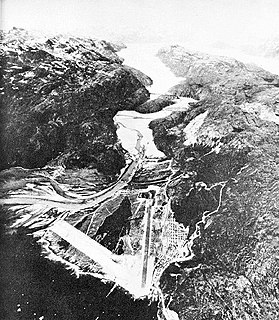
Dundas Harbour is an abandoned settlement in the Qikiqtaaluk Region, Nunavut, Canada. It is located on Devon Island at the eastern shore of the waterway also named Dundas Harbour. Baffin Bay's Croker Bay is immediately to the west.
Cape Parry is a headland in Canada's Northwest Territories. Located at the northern tip of the Parry Peninsula, it projects into Amundsen Gulf. The nearest settlement is Paulatuk, 100 km (62 mi) to the south, and Fiji Island is located 9 km (5.6 mi) to the west. Cape Parry was formerly accessible through Cape Parry Airport that was located at the Distant Early Warning Line. The airport was listed as abandoned after the closure of the DEW line site.

Cape Lisburne Air Force Station is a closed United States Air Force General Surveillance Radar station. It is located 276.5 miles (445.0 km) west-southwest of Point Barrow, Alaska.

The Prince Christian Sound is a waterway in Southern Greenland. It separates the mainland from Sammisoq and other islands of the Cape Farewell Archipelago near the southernmost tip of Greenland. The name was given in honour of the prince, later king Christian VIII of Denmark.
References
- ↑ "And what about Cape Christian?". Nunatsiaq News. May 6, 2005. Archived from the original on 3 April 2012. Retrieved 26 August 2011.
- ↑ Bell, Patricia (July 23, 2009). "Toxins to be removed from former Arctic military site". CBC News. Retrieved 26 August 2011.
Coordinates: 70°31′01″N68°16′48″W / 70.517°N 68.280°W
| | This Qikiqtaaluk Region, Nunavut location article is a stub. You can help Wikipedia by expanding it. |