Burcott is a hamlet in the parish of Bierton with Broughton, Buckinghamshire, England.

Bircotes is an area in the civil parish of Harworth Bircotes in the Bassetlaw district of Nottinghamshire, England on the border with South Yorkshire. The population of the civil parish was 7,948. The local school in the area is Serlby Park Academy. Bircotes was founded in the 1920s, with the discovery of coal during the First World War and the establishment of Harworth Colliery, to provide homes for miners. It is was home to one of the last deep-mine pits in the UK.

Culbokie is a small village in Ross and Cromarty, Highland, Scotland. It is located on the north side of the Black Isle. The village is 3 miles (5 km) south-east of Dingwall and about 9 miles (14 km) north of Inverness.

Aston Mullins is a hamlet in the parish of Dinton, in Buckinghamshire, England. At the 2011 Census the population of the hamlet was included in the civil parish of Dinton-with-Ford and Upton

Barmpton is a small village and civil parish in the borough of Darlington and the ceremonial county of County Durham, England. The population taken at the 2011 Census was less than 100. Details are maintained in the parish of Great Burdon. It is situated a short distance to the north-east of Darlington, on the River Skerne, a tributary of the Tees.

Upper Lambourn is a small village in the county of Berkshire, England. The village is situated in the civil parish of Lambourn, and is 1.2 miles (2 km) to the north-west of the village of Lambourn, just off the Lambourn to Shrivenham road. The parish is within the district of West Berkshire, close to the point where the counties of Berkshire, Oxfordshire and Wiltshire meet.

Walton on the Wolds is a village and civil parish in the Charnwood district of Leicestershire, England. In the United Kingdom Census 2011 the parish had a population of 288. It is near to Burton on the Wolds and Barrow upon Soar. It was the location of one series of Boon, starring Neil Morrissey. The series used the Tudor house, Kings Cote, as Boon's house.

Ballidon is a village and civil parish in the Derbyshire Dales district of Derbyshire, England, on the edge of the Peak District National Park. According to the 2001 census it had a population of 79. The population at the 2011 Census remained less than 100. Details are maintained in the civil Parish of Aldwark, Derbyshire.

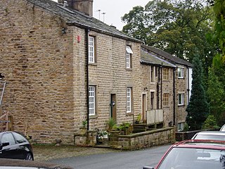
Barrow is a civil parish, in the unitary authority of Cheshire West and Chester and the ceremonial county of Cheshire, England. The civil parish contains the village of Great Barrow and the hamlets of Little Barrow, Broomhill and Stamford Bridge. Great Barrow is situated about 4.5 miles east-north-east of Chester, 6 miles north-west of Tarporley and 6 miles south of Frodsham.
Beaworthy is a village and civil parish in the West Devon district of Devon, England. According to the 2001 census it had a population of 236.

Brushfield is a hamlet and civil parish in the Derbyshire Dales district of Derbyshire, England, in the Peak District National Park. It is about 8 miles east of Buxton. According to the 2001 census it had a population of 13. In 2007 it had just three houses. Several holiday lets are run by two separate families. One of these cottages is called the 'Old School House', a small one-bed house of stone.
Dendron is a small village in South Cumbria, England. It is situated around three miles from the town of Barrow-in-Furness. The village was once just a collection of farms, but many of the old farm buildings have now been converted into houses for commuters working in Barrow, Ulverston and Dalton.

Finghall is a village and civil parish in the Richmondshire district of North Yorkshire, England.
The hamlet of Beacon Hill, is situated off the B474 near Penn and on the outskirts of High Wycombe Buckinghamshire. Nearby is the Golf Course at Wycombe Heights.
Wiswell is a small village and civil parish in the Ribble Valley, Lancashire, England, close to Whalley and Clitheroe at the foot of Wiswell Moor.

Barrowburn is a hamlet in Upper Coquetdale in the county of Northumberland, England. It comprises a working farm with associated buildings and two holiday lets. One of the holiday lets is the Old School House, which closed as a school in the 1970s. The settlement is situated by the River Coquet, at its confluence with Barrow Burn (stream), after which the settlement is named. There is a road bridge over the Coquet and a ford over the burn here.

Pendleton is a small village and civil parish in Ribble Valley, within the county of Lancashire, England. It is close to the towns of Whalley and Clitheroe. The parish lies on the north west side of Pendle Hill below the Nick o' Pendle. The village is just off the A59, Liverpool to York main road, since the construction of the Clitheroe By-Pass. Older roads through the parish include one from Clitheroe to Whalley which passes through the Standen area and another to Burnley which passes Pendleton Hall.

Ordnance Survey (OS) is the national mapping agency for Great Britain. The agency's name indicates its original military purpose, which was to map Scotland in the wake of the Jacobite rising of 1745. There was also a more general and nationwide need in light of the potential threat of invasion during the Napoleonic Wars. Since 1 April 2015 Ordnance Survey has operated as Ordnance Survey Ltd, a government-owned company, 100% in public ownership. The Ordnance Survey Board remains accountable to the Secretary of State for Business, Energy and Industrial Strategy. It was also a member of the Public Data Group.
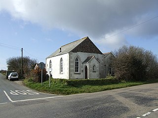
Mount Hermon is a hamlet in the parish of Grade-Ruan in Cornwall, England. It is situated to the east of the A3083 road from Helston to Lizard. There is a round barrow situated to the north east of the houses. There was formerly a chapel, marked as Ebenezer Chapel on the 1879 map, but this has been converted into accommodation, and is now called Ebenezer Cottage.
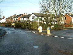
Bickerstaffe is a civil parish in the West Lancashire district of Lancashire, England. It contains twelve listed buildings that are recorded in the National Heritage List for England. All of the listed buildings are designated at Grade II, the lowest of the three grades, which is applied to "buildings of national importance and special interest". The parish contains the village of Bickerstaffe and the hamlet of Barrow Nook, and is otherwise rural. The listed buildings include houses, farmhouses and farm buildings, a church, structures associated with the Friends' Burial Ground, a converted windmill, a boundary stone, stocks, and a war memorial.