Read is a village in Lancashire 5 miles west northwest of Burnley and 2 miles east of Whalley. It is on the A671 which is the main road between Burnley and Clitheroe. The population of the civil parish as taken at the 2011 census was 1,419.

Halton is a local government district in the ceremonial county of Cheshire in North West England, with borough status and administered by a unitary authority. It was created in 1974 as a district of the non-metropolitan county of Cheshire, and became a unitary authority area on 1 April 1998 under Halton Borough Council. Since 2014 it has been a member of the Liverpool City Region Combined Authority. The borough consists of the towns of Runcorn and Widnes and the civil parishes of Daresbury, Hale, Halebank, Moore, Preston Brook, and Sandymoor. The district borders Merseyside, Warrington and Cheshire West and Chester.

Parbold is a village and civil parish in West Lancashire, England.
Burton-in-Kendal is a village and civil parish on the extreme southern edge of Cumbria, England. The parish contains around 660 houses and in the 2001 census had a population of 1,411, increasing at the 2011 census to 1,497. Historically within the county of Westmorland, the village straddles the A6070 road between Crooklands and Carnforth, at a point around midway between Lancaster and Kendal, and is in the shadow of the nearby limestone outcrop known as Farleton Knott.

Heywood is a town in the Metropolitan Borough of Rochdale, Greater Manchester, England. Within the boundaries of the historic county of Lancashire, it had a population of 28,205 at the 2011 Census. The town lies on the south bank of the River Roch, 2.4 miles (3.9 km) east of Bury, 3.7 miles (6.0 km) west-southwest of Rochdale, and 7.4 miles (11.9 km) north of Manchester. Middleton lies to the south, whilst to the north is the Cheesden Valley, open moorland, and the Pennines. Heywood's nickname, Monkey Town, is known to date back to 1857.

Radcliffe is a market town in the Metropolitan Borough of Bury, Greater Manchester, England. It lies in the Irwell Valley 6.5 miles (10 km) north-northwest of Manchester and 2.5 miles (4 km) south-west of Bury and is contiguous with Whitefield to the south. The disused Manchester Bolton & Bury Canal bisects the town.

Eccles is a town in the City of Salford in Greater Manchester, England. Eccles is 2.7 miles (4.3 km) west of Salford and 3.7 miles (6.0 km) west of Manchester, split by the M602 motorway and bordered by the Manchester Ship Canal to the south. The town is famous for the Eccles cake.

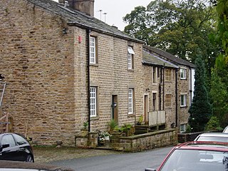
Goosnargh is a village and civil parish in the City of Preston district of Lancashire, England.

Lathom is a village and civil parish in Lancashire, England, about 3 miles (5 km) northeast of Ormskirk. It is in the district of West Lancashire, and with the parish of Newburgh forms part of Newburgh ward. The population of the civil parish at the 2011 census was 914. The Leeds and Liverpool Canal passes through Lathom.
Abram is a village and electoral ward in the Metropolitan Borough of Wigan, Greater Manchester, England. It lies on flat land on the northeast bank of the Leeds and Liverpool Canal, 2 miles (3.2 km) west of Leigh, 3 miles (4.8 km) southeast of Wigan, and 14.5 miles (23 km) west of Manchester. Abram is a dormitory village with a population of 9,855.

Blackrod is a town and civil parish in the Metropolitan Borough of Bolton, Greater Manchester, England, 3.9 miles (6.3 km) northeast of Wigan and 6.6 miles (10.6 km) west of Bolton. At the United Kingdom Census 2011, it had a population of 5,001.

Partington is a town and civil parish in the Metropolitan Borough of Trafford, Greater Manchester, England, ten miles (16 km) south-west of Manchester city centre. Within the boundaries of the historic county of Cheshire, it lies on the southern bank of the Manchester Ship Canal, opposite Cadishead on the northern bank. It has a population of 7,327.

Billinge is a village within the Metropolitan Borough of St Helens, Merseyside, England. It forms the larger part of the civil parish of Billinge Chapel End.

Bickerstaffe is a village and civil parish in the West Lancashire district of Lancashire, England. According to the 2001 Census the population of the civil parish was 1,196, reducing to 1,180 at the 2011 census, although the population of the electoral ward, which includes Lathom South, was slightly greater at 2,013, reducing to 1,988 at the 2011 census. The village is near junction 3 of the M58 motorway, and is about four miles west of Skelmersdale. Until October 1936 Bickerstaffe Colliery was located just south of junction 3.

Simonswood is a civil parish in the West Lancashire district of Lancashire, England. At the 2001 census, the population was 130, increasing to 151 by the 2011 census.

Brindle is a small village and civil parish of the borough of Chorley, Lancashire, England. The population of the civil parish at the 2011 census was 978. It is in the centre of a triangle between Preston, Blackburn, and Chorley. The area has little industry. Brindle is one of the more affluent areas in Lancashire, with average earnings over 33% higher than the national average. Occupations include professionals, teachers, and an increasingly retired population as well as some remaining agricultural employment.
Wiswell is a small village and civil parish in the Ribble Valley, Lancashire, England, close to Whalley and Clitheroe at the foot of Wiswell Moor.

Briercliffe is a civil parish in the borough of Burnley, in Lancashire, England. It is situated 3 miles (4.8 km) north of Burnley. The parish contains suburbs of Burnley, and the rural area north east of the town. Hamlets in the parish include Cockden, Lane Bottom and in the Extwistle area, the tiny hamlet of Roggerham. According to the United Kingdom Census 2011, the parish has a population of 4,031.

The City of Preston is a city and non-metropolitan district in Lancashire, England. On the north bank of the River Ribble, it was granted city status in 2002, becoming England's 50th city in the 50th year of Queen Elizabeth II's reign. The City of Preston district has a population of 143,135 (mid-2019 est.), and lies at the centre of the Central Lancashire sub-region, with a population of 335,000.
Dalton is a civil parish in the West Lancashire district of Lancashire, England. It contains ten buildings that are recorded in the National Heritage List for England as designated listed buildings. Of these, one is at Grade II*, the middle grade, and the others are at Grade II, the lowest grade. The parish contains the village of Dalton, and is otherwise rural. Most of the listed buildings are farmhouses, or houses and associated structures, the others being a church, and a landmark in the form of a beacon.