Bathurst Harbour, Tasmania

Last updated

Bathurst Harbour
Bathurst Harbour SW Tas5.jpg
Forest Lagoon, an offshoot of Bathurst Harbour, looking south with "Claytons Corner" in lower right
Relief Map of Tasmania.png
Red pog.svg
Bathurst Harbour
Location in Tasmania
Location South West Tasmania
Coordinates 43°20′33.68″S146°10′32.38″E / 43.3426889°S 146.1756611°E / -43.3426889; 146.1756611 Coordinates: 43°20′33.68″S146°10′32.38″E / 43.3426889°S 146.1756611°E / -43.3426889; 146.1756611
River sourcesNorth River, Old River, Ray River and Melaleuca Creek
Primary outflows Bathurst Channel to Port Davey and then the Southern Ocean
Basin  countriesAustralia
Average depth3 to 7 metres (9.8 to 23.0 ft) [1]
Max. depth29 metres (95 ft)
Settlements Melaleuca

Bathurst Harbour is a shallow bay located in the south west region of Tasmania, Australia. Bathurst Harbour is contained within the Port Davey/Bathurst Harbour Marine Nature Reserve, [2] and the Southwest National Park, part of the Tasmanian Wilderness World Heritage Area.

Contents

The harbour is an expansive, almost landlocked, shallow bay of relatively uniform depth ranging from 3 to 7 metres (9.8 to 23.0 ft), [1] which provides safe anchorage from the Roaring Forties that buffet the western and southern coasts of Tasmania. The harbour is connected by the narrow 12-kilometre (7.5 mi)-long Bathurst Channel to Port Davey, and then water flows into the Southern Ocean. Like most estuarine systems in southwest Tasmania, the water is stained a deep red-brown due to tannin leached from buttongrass and adjacent heathland. [1]

Features and location

Bathurst Harbour is a large, rectangular, almost landlocked body of water located in the southwest corner of Tasmania. The harbour is surrounded by low-lying alluvial plains with mountain ranges running along the western and eastern shores. The North River, Old River, Ray River and Melaleuca Creek all drain into the harbour either directly or into one of the many offshoot bays and inlets connected to the harbour.

Almost all of the harbour is navigable by sailing vessels with no submerged rocks or navigational hazards except for a small area around Black Swan Island at Old Bay in the harbours north. Of the four main inflows only Melaleuca Creek is truly navigable and maintains a depth in excess of 2–3 metres (6 ft 7 in – 9 ft 10 in) for more than 6.5 kilometres (4.0 mi) upstream of "Claytons Corner" which provides marine access to Melaleuca. With the exception of the waters around the harbour entrance, most of the harbour has a relatively flat seabed with an average depth of 7 metres (23 ft). As with almost all of the estuarine system including the Bathurst Channel, the seabed falls sharply from the shore before hitting the level floor of the harbour which forms a gently sloping basin of mud and gravel with a maximum depth of 9.1 metres (30 ft) near Dixon Island. Waters within a 2–3-kilometre (1.2–1.9 mi) radius of the harbour entrance vary greatly in depth with three deep channels branching out from the entrance leaving deep shoals in between at a depth of 5 metres (16 ft). The true deepest point in the harbour is where the three channels meet between Platypus Point and Nixon Point which reaches 29 metres (95 ft) due to the dredging action of the tide.

Bathurst Harbour, like the rest of the Bathurst Channel, is a ria formation caused by the inundation of a large valley and its associated alluvial plains. The glacially carved landscape of the region has resulted in the shape of the estuarine system being greatly different to other ria formations around Tasmania such as the Derwent Estuary, instead bearing close resemblance to artificial impoundments like Lake Pedder, 30 kilometres (19 mi) to the north.

Bathurst Harbour is one of only two places in the world where the Maugean Skate, endemic to Tasmania, has been reported from. The main population is found in similar habitats in Macquarie Harbour to the north.

Settlement

The land around the harbour is unpopulated with little infrastructure. Most buildings and structures in the vicinity of the harbour are located at Melaleuca which supports an airstrip, several light structures, boat moorings and remains from the tin mines in the early 1900s. A mining department camp was formerly located at Woureddy Bay on Melaleuca Creek and the homestead "Claytons Corner" is located at the mouth of Melaleuca Creek on Forest Lagoon which includes a timber jetty. At present the region has no permanent population, but has in time had a number reclusive inhabitants.

Access

Bathurst Harbour has no vehicular access of any kind. Access is instead provided by either boat, air or walking. The only marine access to the harbour is via the Bathurst Channel from Port Davey. Two walking tracks, South Coast Track and the Port Davey Track, provide land access via either Cockle Creek or Scotts Peak Dam. An airstrip at Melaleuca gives the only aerial access to the region and is in turn connected to the main walking tracks.

See also

Related Research Articles

Protected areas of Tasmania consist of protected areas located within Tasmania and its immediate onshore waters, including Macquarie Island. It includes areas of crown land managed by Tasmanian Government agencies as well as private reserves. As of 2016, 52% of Tasmania's land area has some form of reservation classification, the majority is managed by the Tasmania Parks & Wildlife Service. Marine protected areas cover about 7.9% of state waters.

<span class="mw-page-title-main">Southwest National Park</span> National park in Tasmania, Australia

Southwest National Park is an Australian national park located in the south-west of Tasmania, bounded by the Franklin-Gordon Wild Rivers National Park to the north and the Hartz Mountains National Park to the east. It is a part of a chain of national parks and state reserves that make up the Tasmanian Wilderness World Heritage Area. Covering an area of 6,183 km2 (2,387 sq mi), it is Tasmania's largest national park.

<span class="mw-page-title-main">Macquarie Harbour</span> Large inlet on the West Coast of Tasmania

Macquarie Harbour is a shallow fjord in the West Coast region of Tasmania, Australia. It is approximately 315 square kilometres (122 sq mi), and has an average depth of 15 metres (49 ft), with deeper places up to 50 metres (160 ft). It is navigable by shallow-draft vessels. The main channel is kept clear by the presence of a rock wall on the outside of the channel's curve. This man-made wall prevents erosion and keeps the channel deep and narrow, rather than allowing the channel to become wide and shallow. A reported Aboriginal name for the harbour is Parralaongatek.

<span class="mw-page-title-main">Lake St Clair (Tasmania)</span> Lake in Tasmania, Australia

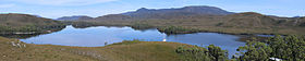
Lake St Clair or leeawulenna is a natural freshwater lake located in the Central Highlands area of Tasmania, Australia. The lake forms the southern end of the Cradle Mountain-Lake St Clair National Park. It has an area of approximately 45 square kilometres (17 sq mi), and a maximum depth of 215 metres (705 ft), making it Australia's deepest lake.

<span class="mw-page-title-main">Kelly Basin</span> Bay in Tasmania, Australia

Kelly Basin is a bay on the south eastern side of Macquarie Harbour on the West Coast of Tasmania.

<span class="mw-page-title-main">South West Wilderness</span>

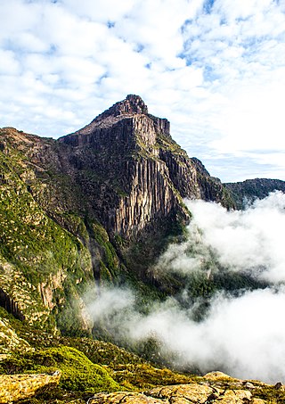
The South West Wilderness of Tasmania, Australia is a remote and inaccessible region of South West Tasmania containing unspoilt scenery, rugged peaks, wild rivers, unique flora and fauna, and a long and rugged coastline. Parts of the wilderness are more than 50 km from the nearest road, so the only access to the area is by foot, air or sea.

<span class="mw-page-title-main">Breaksea Islands (Tasmania)</span> Island group in Tasmania, Australia

The Breaksea Islands Group is a group of six islands, in the Southern Ocean, off the southwestern coast of Tasmania, Australia.

Kathleen Island is a steeply cliffed island that lies within Port Davey, an oceanic inlet, located in the south west region of Tasmania, Australia. The island has an area of approximately 11.35 hectares and is contained with the Southwest National Park, part of the Tasmanian Wilderness World Heritage Site and the Port Davey/Bathurst Harbour Marine Nature Reserve.

<span class="mw-page-title-main">South West Tasmania</span> Region in Tasmania, Australia

South West Tasmania is a region in Tasmania that has evoked curiosity as to its resources over the duration of European presence on the island.

<span class="mw-page-title-main">Tasmania Parks and Wildlife Service</span> Government body of Tasmania, Australia

Tasmania Parks and Wildlife Service is the government body responsible for protected areas of Tasmania on public land, such as national parks, historic sites and regional reserves. Historically it has also had responsibility for managing wildlife, including game.

<span class="mw-page-title-main">South Coast Track</span> Hiking trail in Southwest National Park, Tasmania, Australia

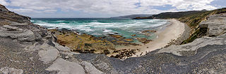
The South Coast Track is a bushwalking track located in the South Coast region of Tasmania, Australia. The 85-kilometre (53 mi) track traverses remote wilderness within the Southwest National Park, part of the Tasmanian Wilderness World Heritage Site, and is managed as a wilderness walk. The Tasmanian Parks & Wildlife Service recommend that experienced bushwalkers can take six-to-eight days to cover the track in one direction.

Port Davey is an oceanic inlet located in the south west region of Tasmania, Australia.

The Davey River is a perennial river located in the south-west region of Tasmania, Australia.

<span class="mw-page-title-main">South West Mutton Bird Islet</span> Islet on south west coast of Tasmania, Australia

South West Mutton Bird Islet is a dome-shaped unpopulated islet located close to the south-western coast of Tasmania, Australia. Situated some 2 kilometres (1.2 mi) south of where the mouth of Port Davey meets the Southern Ocean, the 0.52-hectare (1.3-acre) islet is one of the eight islands that comprise the Mutton Bird Islands Group. The South West Mutton Bird Islet is part of the Southwest National Park and the Tasmanian Wilderness World Heritage Site.

<span class="mw-page-title-main">Mutton Bird Island</span> Island in Tasmania, Australia

Mutton Bird Island is an irregularly shaped unpopulated island located close to the south-western coast of Tasmania, Australia. Situated some 2 kilometres (1.2 mi) south of where the mouth of Port Davey meets the Southern Ocean, the 44-hectare (110-acre) is the largest of the eight islands that comprise the Mutton Bird Islands Group. The Mutton Bird Island is part of the Southwest National Park and the Tasmanian Wilderness World Heritage Site.

The Fitzroy Islands comprise a group of four rocky islets that lie within the upper reaches of Payne Bay in Port Davey, an oceanic inlet, located in the south west region of Tasmania, Australia. The islands have a combined area of approximately 0.18 hectares and are contained with the Southwest National Park, part of the Tasmanian Wilderness World Heritage Site and the Port Davey/Bathurst Harbour Marine Nature Reserve.

The Mavourneen Rocks is a group of four steep, rocky islets that lie within Port Davey, an oceanic inlet, located in the south west region of Tasmania, Australia. The islets have a combined area of approximately 0.88 hectares and are contained with the Southwest National Park, part of the Tasmanian Wilderness World Heritage Site and the Port Davey/Bathurst Harbour Marine Nature Reserve.

Munday Island is a small island that lies between Port Davey, an oceanic inlet, and Bathurst Channel, located in the south west region of Tasmania, Australia. The island is contained with the Southwest National Park, part of the Tasmanian Wilderness World Heritage Site and the Port Davey/Bathurst Harbour Marine Nature Reserve.

The Port Davey Track, officially the Old Port Davey Track, is a bushwalking track located in the south western region of Tasmania, Australia. The 70-kilometre (43 mi) track traverses remote wilderness within the Southwest National Park, part of the Tasmanian Wilderness World Heritage Site, and is managed as a wilderness walk. The Tasmanian Parks & Wildlife Service recommend that experienced bushwalkers can take four-to-five days to cover the track in one direction.

The Bathurst Channel is a narrow offshore stretch of water that links Port Davey with Bathurst Harbour in the South West region of Tasmania, Australia. The Bathurst Channel is contained within the Port Davey/Bathurst Harbour Marine Nature Reserve, and the Southwest National Park, part of the Tasmanian Wilderness World Heritage Area.

References

  1. 1 2 3 Hirst, Alastair; Barrett, Neville; Meyer, Lisa; Reid, Catherine (November 2007). "Port Davey – Bathurst Harbour marine benthic survey" (PDF). Tasmanian Aquaculture and Fisheries Institute. University of Tasmania. p. 7. Archived from the original (PDF) on 11 April 2015. Retrieved 11 July 2015.
  2. "Port Davey/Bathurst Harbour Marine Nature Reserve". Sea Fishing & Aquaculture: Area Restrictions: Marine Reserves. Department of Primary Industries, Parks, Water and Environment, Tasmanian Government. 3 September 2014. Retrieved 10 July 2015.

Further reading