
Macquarie Harbour is a large, shallow, inlet, located in the West Coast region of Tasmania, Australia. It is approximately 315 sq.km, and has an average depth of 15m, with deeper places up to 50m. The inlet is navigable by shallow-draft vessels. The main channel is kept clear by the presence of a rock wall on the outside of the channel's curve. This man-made wall prevents erosion and keeps the channel deep and narrow, rather than allowing the channel to become wide and shallow. A reported Aboriginal name for the harbour is Parralaongatek.

ABC NewsRadio is an Australian Broadcasting Corporation 24-hour news radio service. It is available on a number of broadcasts around Australia, including AM/FM radio, DAB+ radio, free to air digital TV, some pay-TV platforms and online.

The Macquarie Harbour Penal Station, a former British colonial penal settlement, established on Sarah Island, Macquarie Harbour, in the former colony of Van Diemen's Land, now Tasmania, operated between 1822 and 1833. The settlement housed male convicts, with a small number of women housed on a nearby island. During its 11 years of operation, the penal colony achieved a reputation as one of the harshest penal settlements in the Australian colonies. The formal penal station is located on the eight-hectare (twenty-acre) Sarah Island that now operates as an historic site under the direction of the Tasmania Parks and Wildlife Service.

The West Coast of Tasmania has a significant convict heritage. The use of the West Coast as an outpost to house convicts in isolated penal settlements occurred in the eras 1822–33, and 1846–47.
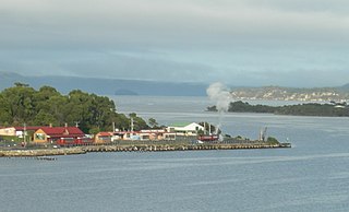
Regatta Point is the location of a port and rail terminus on Macquarie Harbour.

Hells Gates is the name of the mouth of Macquarie Harbour on the West Coast of Tasmania.

Mount Murchison is a mountain on the West Coast Range, located in the West Coast region of Tasmania, Australia.
South West Tasmania is a region in Tasmania that has evoked curiosity as to its resources over the duration of European presence on the island.

Bathurst Harbour is a shallow bay located in the south west region of Tasmania, Australia. Bathurst Harbour is contained within the Port Davey/Bathurst Harbour Marine Nature Reserve, and the Southwest National Park, part of the Tasmanian Wilderness World Heritage Area.
The following lists events that happened during 1878 in Australia.
Port Davey is an oceanic inlet located in the south west region of Tasmania, Australia.

William Charles Piguenit was an Australian landscape painter.
The Low Rocky Point is a location on the south west coast of Tasmania, Australia, that is used as a location for weather forecasting. It is almost due west of Hobart, it is south of Point Hibbs and north of South West Cape.
The Serpentine River is a major perennial river located in the south-west and western regions of Tasmania, Australia.
Point Hibbs is a headland on the south-west coast of Tasmania, Australia. The headland is located south of the most southern point of Macquarie Harbour, and west of the Gordon River. It is the next named feature along the coast south of Cape Sorell that is used to delineate sections of the coast. Like South West Cape, it is used as a reference point for nearby wrecks.
The Bathurst Channel is a narrow offshore stretch of water that links Port Davey with Bathurst Harbour in the South West region of Tasmania, Australia. The Bathurst Channel is contained within the Port Davey/Bathurst Harbour Marine Nature Reserve, and the Southwest National Park, part of the Tasmanian Wilderness World Heritage Area.
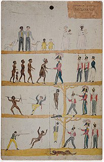
Governor Davey's Proclamation is a misnomer for an illustrated proclamation issued in Tasmania by the British government after 1 November 1828. Although attributed to Governor Davey it was first authorised by Lieutenant Governor George Arthur. Several illustrated narrative versions of the proclamation were created over time. Many of these four-strip pictograms were originally painted onto Huon pine boards using oil paints. Of approximately 100 proclamation boards produced there are seven known to survive in public collections.
Denison River is a river in South West Tasmania, Australia. It is within the South West Wilderness, and drains into the Gordon River below the Gordon Splits. Its catchment starts in the south of the King William Range.
Mount Olympus is a mountain in the Cradle Mountain-Lake St Clair National Park in Tasmania, Australia. It is the 24th highest mountain in Tasmania at 1,472 metres (4,829 ft) above sea level and is situated about 8 kilometres (5.0 mi) South-East of Mount Gould and about 4 kilometres (2.5 mi) west of Lake St. Clair.

The British and Tasmanian Charcoal Iron Company (BTCIC) was an iron mining and smelting company that operated from 1874 to 1878 in Northern Tasmania, Australia. It was formed by floating the operations of a private company, the Tasmanian Charcoal Iron Company that operated between 1871 and 1874.
