
Sullivans Cove is on the River Derwent adjacent to the Hobart City Centre in Tasmania. It was the site of initial European settlement in the area, and the location of the earlier components of the Port of Hobart.

The South West Cape is a cape located at the south-west corner of Tasmania, Australia. The cape is situated in the south-western corner of the Southwest National Park, part of the Tasmanian Wilderness World Heritage Area, approximately 140 kilometres (87 mi) southwest of Hobart in Tasmania, and about 65 kilometres (40 mi) west and a little north of the South East Cape.

Maria Island or 'wukaluwikiwayna' in [palawa kani) is a mountainous island located in the Tasman Sea, off the east coast of Tasmania, Australia. The 115.5-square-kilometre (44.6 sq mi) island is contained within the Maria Island National Park, which includes a marine area of 18.78 square kilometres (7.25 sq mi) off the island's northwest coast. The island is about 20 kilometres (12 mi) in length from north to south and, at its widest, is about 13 kilometres (8.1 mi) west to east. At its closest point, Point Lesueur, the island lies approximately 4 kilometres (2.5 mi) off the east coast of Tasmania.

Hells Gates is the name of the mouth of Macquarie Harbour on the West Coast of Tasmania.
Trial Harbour is a rural locality in the local government area (LGA) of West Coast in the North-west and west LGA region of Tasmania. The locality is about 20 kilometres (12 mi) south-west of the town of Zeehan. The 2016 census has a population of 24 for the state suburb of Trial Harbour.

Mount Owen is a mountain directly east of the town of Queenstown on the West Coast Range in Western Tasmania, Australia.
The mines of the West Coast of Tasmania have a rich historical heritage as well as an important mineralogical value in containing or having had found, specimens of rare and unusual minerals. Also, the various mining fields have important roles in the understanding of the mineralization of the Mount Read Volcanics, and the occurrence of economic minerals.
The Strahan–Zeehan Railway, also known as the "Government Railway", was a railway from Strahan to Zeehan on the west coast of Tasmania.
The Montezuma Falls, a horsetail waterfall on a minor tributary to the Pieman River, is located on the West Coast Range of Tasmania, Australia.
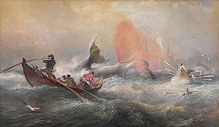
Whaling in Australian waters began in 1791 when five of the 11 ships in the Third Fleet landed their passengers and freight at Sydney Cove and then left Port Jackson to engage in whaling and seal hunting off the coast of Australia and New Zealand. The two main species hunted by such vessels in the early years were right and sperm whales. Humpback, bowhead and other whale species would later be taken.
Thomas Bather Moore was a pioneer explorer of Western and South West, Tasmania, Australia.
Port Davey is an oceanic inlet located in the south west region of Tasmania, Australia.
The Macquarie Heads Breakwater was a project of the Strahan Marine Board in Western Tasmania to sustain a reasonable depth to the Hells Gates and Macquarie Heads of the Macquarie Harbour area to allow for shipping of limited tonnage to serve Regatta Point while the Mount Lyell Mining and Railway Company was exporting its mineral products by sea. The heads were notoriously difficult to navigate in good weather, and even more difficult in bad weather.
Point Hibbs is a headland on the south-west coast of Tasmania, Australia. The headland is located south of the most southern point of Macquarie Harbour, and west of the Gordon River. It is the next named feature along the coast south of Cape Sorell that is used to delineate sections of the coast. Like South West Cape, it is used as a reference point for nearby wrecks.
The Spero River is a perennial river located in the West Coast or South West region of Tasmania, Australia.
The High Rocky Point is a coastal landmark, located on the south western coast of Tasmania, Australia. The point, contained within the Southwest National Park, part of the Tasmanian Wilderness World Heritage Site, lies to the south of Point Hibbs and north of Low Rocky Point that is located approximately 20 kilometres (12 mi) away. The Wanderer River is located to the north of the point.

Cape Pillar is a rural locality in the local government area (LGA) of Tasman in the South-east LGA region of Tasmania. The locality is about 27 kilometres (17 mi) south-east of the town of Nubeena. The 2016 census recorded a population of 4 for the state suburb of Cape Pillar. It is on the Tasman Peninsula in the Tasman National Park, adjacent to Tasman Island.

Queenstown Airport is an aerodrome located at Howard's Plains west of Queenstown, Tasmania, Australia. Formerly a commercial airport, the aerodrome no longer receives regular passenger services, but is maintained by the West Coast Council for a variety of aviation and non-aviation related uses.

Isle of the Dead is an island, about 1 hectare in area, adjacent to Port Arthur, Tasmania, Australia. It is historically significant since it retains an Aboriginal coastal shell midden, one of the first recorded sea-level benchmarks, and one of the few preserved Australian convict-period burial grounds. The Isle of the Dead occupies part of the Port Arthur Historic Site, is part of Australian Convict Sites and is listed as a World Heritage Property because it represents convictism in the era of British colonisation.
Taroona Beach is a popular beach destination along the River Derwent in Taroona, Hobart, Tasmania. The south facing beach looks directly out to Storm Bay and the Tasman Sea, with views of the Derwent estuary, the City of Clarence on the eastern shore, Opossum Bay, South Arm, the Alum Cliffs and northern tip of Bruny Island. Taroona Beach is situated between Hinsby Beach and Crayfish Point, home of the Fisheries and Aquaculture Centre for the Institute for Marine and Antarctic Studies. Taroona Beach contains a boat ramp and is backed by Taroona Park which contains bathroom facilities, a skate park, scout hall, the Taroona Tennis Club, and the Taroona Bowls and Community Club.
