Bawdrip Halt railway station

Last updated

Bawdrip Halt
General information
Location Bawdrip
England
Platforms1
Other information
StatusDisused
History
Original company Somerset and Dorset Joint Railway
Key dates
7 July 1923 (1923-07-07)Station opened as Bawdrip Halt
1 December 1952 (1952-12-01)Station closed

Bawdrip Halt was a railway station at Bawdrip on the Bridgwater branch of the Somerset and Dorset Joint Railway.

Contents

Although the line had opened in 1890, station facilities at Bawdrip were not provided until 7 July 1923, after petitioning by local people. The new halt was surprisingly popular, with 2,185 passengers using it between 7 July and 29 September 1923.

It consisted of a single concrete platform 140 feet long; a waiting shelter was provided during 1924. [1]

The station closed when the branch service was withdrawn on 1 December 1952.

Preceding station Disused railways Following station
Cossington
Line and station closed
  Somerset & Dorset Joint Railway
LSWR and Midland Railways
  Bridgwater North
Line and station closed

Related Research Articles

Bridgwater Human settlement in England

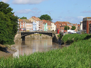
Bridgwater is a large historic market town and civil parish in Somerset, England. Its population currently stands at around 41,276 as of 2022. Bridgwater is at the edge of the Somerset Levels, in level and well-wooded country. The town lies along both sides of the River Parrett; it has been a major inland port and trading centre since the industrial revolution. Most of its industrial bases still stand today. Its larger neighbour, Taunton, is linked to Bridgwater via a canal, the M5 motorway and the GWR railway line.

Somerset and Dorset Joint Railway Disused railway line in England

The Somerset & Dorset Joint Railway, also known as the S&D, SDJR or S&DJR, was an English railway line connecting Bath and Bournemouth, with a branch from Evercreech Junction to Burnham-on-Sea and Bridgwater. Strictly speaking, the main line ran from Bath Junction to Broadstone, as the line between Broadstone and Bournemouth was owned by the London and South Western Railway, while the line between Bath Junction and Bath was owned by the Midland Railway.

Polden Hills

Polden Hills in Somerset, England are a long, low ridge, extending for 10 miles (16 km), and separated from the Mendip Hills, to which they are nearly parallel, by a marshy tract, known as the Somerset Levels. They are now bisected at their western end by the M5 motorway and a railway, the Bristol and Exeter Railway, part of the Great Western Main Line.

Bridgwater railway station Railway station in Somerset, England

Bridgwater railway station serves Bridgwater in Somerset, England. It is on the Bristol to Taunton Line and is operated by Great Western Railway. It is 151 miles 47 chains from the zero point at London Paddington via Box.

Bristol and Exeter Railway Former English railway company

The Bristol & Exeter Railway (B&ER) was an English railway company formed to connect Bristol and Exeter. It was built on the broad gauge and its engineer was Isambard Kingdom Brunel. It opened in stages between 1841 and 1844. It was allied with the Great Western Railway (GWR), which built its main line between London and Bristol, and in time formed part of a through route between London and Cornwall.

Midford railway station Former railway station in Somerset, England

Midford railway station was a single-platform station on the Bath extension of the Somerset and Dorset Railway, just to the north of the point where the double-track became a single track. It served the village of Midford. The station was closed with the rest of the line in March 1966 under the Beeching axe, though it had been unstaffed for some years before that.

Edington railway station Former railway station in Somerset, England

Edington Burtle railway station was a station on the Somerset and Dorset Joint Railway, and served the village of Edington, Somerset, UK. Originally named Edington Road, with the village two miles away, it became in 1890 the junction for the Bridgwater branch off the Highbridge line and for the next period in its life was known as Edington Junction. After the Bridgwater line closed to passengers in 1952, the station was renamed as Edington Burtle – Burtle is a village to the north of the station, and somewhat closer than Edington. In February 1956 the down platform and signal box was closed. Goods Yard closed on 13 July 1964. It closed in March 1966 when the line was shut as part of the Beeching axe.

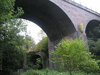
There are 22 disused railway stations in the 75 miles (121 km) between Bristol Temple Meads and Exeter St Davids, 12 of which have structures that can still be seen from passing trains. Most were closed in the 1960s but four of them, especially around Weston-super-Mare, were replaced by stations on new sites. 13 stations remain open on the line today, but there have been proposals to reopen stations at Cullompton and Wellington.

Long Ashton railway station Railway station in England

Long Ashton railway station was a railway station on the Bristol to Exeter line, 3.5 miles (5.6 km) southwest of Bristol Temple Meads, serving the village of Long Ashton in North Somerset, England. There were two stations on the site, the first, called "Ashton", opened in either 1841 or 1852 and closed in 1856. The second station, originally known as "Long Ashton Platform" before being renamed as "Long Ashton" in 1929, was operational from 1926 to 1941. The site is now partly under the A370 Long Ashton Bypass, and there are no visible remains of the station. There is local support for the station to be reopened, possibly sited further to the west, and possibly as part of the University of Bristol's proposed Fenswood Farm development.

Spetisbury railway station

Spetisbury railway station was a station in the English county of Dorset. It was located between Blandford Forum and Bailey Gate on the Somerset and Dorset Joint Railway. The station consisted of two platforms, a station building, signal box and shelters.

Pylle railway station was a station on the Highbridge branch of the Somerset and Dorset Joint Railway. Opened 3 February 1862 on the original S&DJR main line, the railway was reduced to branch status when the extension from Evercreech Junction to Bath was opened. It was built with a passing loop on the single line however the loop was removed in 1929 at the same time as the signal box. It was reduced to halt status on 4 November 1957 and closed with the railway, on 7 March 1966.

West Pennard railway station was a station on the Highbridge branch of the Somerset and Dorset Joint Railway. Opened on 3 February 1862, it was reduced to halt status on 25 June 1962. Originally the S&DJR main line, the railway was reduced to branch status when the extension to Bath was built. A passing point on the single line, the station was adjacent to a level crossing on the A361 road from Shepton Mallet to Glastonbury. The station closed with the railway on 7 March 1966.

Ashcott railway station Disused railway station in Ashcott, Sedgemoor

Ashcott railway station was a station on the Highbridge branch of the Somerset and Dorset Joint Railway. Opened by the Somerset Central Railway in 1856 as Ashcott and Meare, the name changed to Ashcott in 1876. Consisting of a short wooden platform and station building, the station was next to a road level crossing. This was operated with a 10 lever ground frame.

Cossington railway station Railway station in Sedgemoor, England

Cossington railway station was a station at Cossington on the Bridgwater branch of the Somerset and Dorset Joint Railway, built to link the line at Edington with Bridgwater.

Bridgwater North railway station

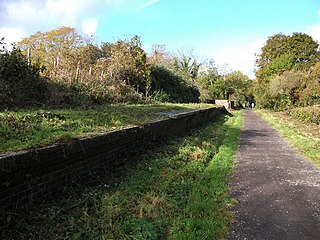
Bridgwater North railway station was the terminus of the Bridgwater Railway, which ran from a junction with the Somerset and Dorset Joint Railway at Edington, between 1890 and 1954. Although often regarded as part of the Somerset and Dorset Joint Railway, and effectively worked as part of that system, the Bridgwater Railway remained nominally independent until the railway Grouping of 1923 when it was vested in the Somerset and Dorset Joint Railway group.

Midford Halt railway station

Midford Halt railway station was open between 1911 and 1915 in Somerset, England. The halt was on the Limpley Stoke to Camerton railway that formed part of the Great Western Railway's development of the former Bristol and North Somerset Railway, and which followed the former Somerset Coal Canal. The line was only open to passenger traffic for seven years in all, from 1910 to 1915, and from 1923 to 1925; Midford Halt opened a year late and then did not reopen for the second period.

Chard branch line

The Chard branch lines were two lines serving the town of Chard in Somerset, England. One was a northward branch, opened in 1863, from the Salisbury to Exeter main line, and the other, opened in 1866, ran south-eastwards from the Bristol – Taunton main line. Each branch had its own Chard passenger station at first, although the two lines connected in Chard.

Transport in Somerset Overview of transport in Somerset

The earliest known infrastructure for transport in Somerset is a series of wooden trackways laid across the Somerset Levels, an area of low-lying marshy ground. To the west of this district lies the Bristol Channel, while the other boundaries of the county of Somerset are along chains of hills that were once exploited for their mineral deposits. These natural features have all influenced the evolution of the transport network. Roads and railways either followed the hills, or needed causeways to cross the Levels. Harbours were developed, rivers improved, and linked to sources of traffic by canals. Railways were constructed throughout the area, influenced by the needs of the city of Bristol, which lies just to the north of Somerset, and to link the ports of the far south-west with the rest of England.

Port of Bridgwater Port in England

The Port of Bridgwater is a port, originally located in the town of Bridgwater, Somerset, England. Created under an 1845 Act of Parliament, it extends from Brean Down to Hinkley Point in Bridgwater Bay, and parts of the rivers Parrett, River Brue and River Axe. Although no ships now dock in the town, in 2001 103,613 (metric) tonnes of cargo were handled within the area of the Port Authority, most of which were stone products through the wharf at Dunball.

The Yeovil–Taunton line was a railway line in England, built by the Bristol and Exeter Railway (B&ER) to connect its main line with the market town of Yeovil in Somerset. It opened in 1853 using the broad gauge of 7 ft 14 in and was the first railway to serve Yeovil. It ran from a junction at Durston although in later years passenger trains on the line ran through to and from Taunton where better main and branch line connections could be made.

References

  1. Harrison, J D (1990). The Bridgwater Railway. Oakwood Press. ISBN   0-85361-403-2.

Further reading

Coordinates: 51°09′11″N2°56′33″W / 51.15306°N 2.94250°W / 51.15306; -2.94250

Somerset and Dorset Joint Railway
This diagram shows the maximum extent of the line.
All distances and timings are cumulative
from Bath Green Park railway station.

km  
h:min
BSicon exSTRc2.svg
BSicon exKBHF3.svg
0.00
Bath Green Park
originally Queen Square
0:00
BSicon exSTRc2.svg
BSicon exhKRXWaeq.svg
BSicon exSTRc4.svg
BSicon exSTRc2.svg
BSicon exlDST.svg
BSicon exSTR3+1.svg
BSicon exSTRc4.svg
0.40
Bath Goods Depot
BSicon exSTRc2.svg
BSicon exKBSTaq.svg
BSicon exABZ1+3f.svg
BSicon exSTRr+1.svg
BSicon exSTRc4.svg
BSicon exCONTr+1.svg
BSicon exSTR+c4.svg
0.82
0:01
BSicon CONTgq.svg
BSicon xKRZo.svg
BSicon CONTfq.svg
0:02
BSicon exTUNNEL2.svg
Devonshire Tunnel
0:04
BSicon exTUNNEL1.svg
0:05
BSicon exhSTRae.svg
Tucking Mill Viaduct
0:06
BSicon exHST.svg
7.02
Midford
0:10
BSicon exSTR2.svg
BSicon exUWu3.svg
BSicon exlCONTf1.svg
BSicon exSTR3+1.svg
0:11
BSicon exSTR+1u.svg
BSicon exHST+4.svg
10.88
Wellow
0:17
BSicon exLSTR.svg
BSicon exHST.svg
13.80
Shoscombe and Single Hill Halt
0:22
BSicon exABZgl+l.svg
BSicon exKBSTeq.svg
Writhlington Colliery sidings
formerly Foxcote
0:23
BSicon exkLLSTR2.svg
BSicon exHST.svg
17.14
Radstock North
0:26
BSicon exkSTRc1.svg
BSicon exkKRZl+4o.svg
BSicon exCONTfq.svg
0:29
BSicon KHSTxa.svg
20.16
Midsomer Norton
0:35
BSicon dENDE@F.svg
BSicon exTUNNEL2.svg
Chilcompton Tunnel
BSicon exHST.svg
23.32
Chilcompton
0:44
BSicon exHST.svg
27.46
Binegar
0:52
BSicon exGIPl.svg
Summit
247 m above sea level
BSicon exHST2.svg
BSicon exSTRc3.svg
29.99
Masbury
0:56
BSicon exKHSTa.svg
BSicon exSTRc1.svg
BSicon exSTR2+4.svg
BSicon exSTRc3.svg
81.73
Burnham-on-Sea
2:16
BSicon STRc2.svg
BSicon exABZg2.svg
BSicon lCONTf1.svg
BSicon STR3+1.svg
BSicon exSTRc1.svg
BSicon exSTR+4.svg
Bristol and Exeter Railway (GWR)
to Bristol Temple Meads
BSicon xABZg+1.svg
BSicon xSTR+4.svg
BSicon exTUNNEL2.svg
Windsor Hill Tunnel
BSicon HST.svg
BSicon eHST-L.svg
BSicon exHST-R.svg
BSicon exSTR.svg
78.92
Highbridge
2:11
BSicon STR.svg
BSicon exDST.svg
BSicon exSTR.svg
Highbridge Locomotive,
Carriage and Wagon Works
BSicon STR.svg
BSicon exHST.svg
BSicon exSTR.svg
76.28
Bason Bridge
2:06
BSicon STR.svg
BSicon exABZl+l.svg
BSicon exHST+r.svg
BSicon exSTR.svg
70.67
Edington Burtle
1:58
BSicon STR.svg
BSicon exHST.svg
BSicon exSTR.svg
BSicon exSTR.svg
75.10
Cossington
2:04
BSicon STR.svg
BSicon exHST.svg
BSicon exSTR.svg
BSicon exSTR.svg
77.37
Bawdrip Halt
2:09
BSicon eSTR2u.svg
BSicon exSTR3.svg
BSicon exHST.svg
BSicon exSTR.svg
67.17
Shapwick
1:52
BSicon exSTR+1.svg
BSicon eSTR+4u.svg
BSicon exHST.svg
BSicon exSTR.svg
64.09
Ashcott
1:47
BSicon exBST.svg
BSicon STR.svg
BSicon exSTR.svg
BSicon exSTR.svg
Bridgwater Spinx Cement Works
BSicon exBST.svg
BSicon STR.svg
BSicon exSTR.svg
BSicon exSTR.svg
Bridgwater cement, lime,
brick and tile Works
BSicon exKHSTe.svg
BSicon STR.svg
BSicon exSTR.svg
BSicon exSTR.svg
81.94
Bridgwater North
2:12
BSicon HST.svg
BSicon exSTR.svg
BSicon exSTR.svg
Gnome-searchtool.svg
Bridgwater
(GWR)
BSicon CONTf.svg
BSicon exSTR.svg
BSicon exSTR.svg
BSicon exHST.svg
BSicon exSTR.svg
59.75
Glastonbury and Street
1:39
BSicon exSTRc2.svg
BSicon exABZg3.svg
BSicon exSTR.svg
BSicon exSTR+1.svg
BSicon exSTRc4.svg
BSicon exHST.svg
BSicon exSTR.svg
64.57
Polsham
1:47
BSicon exSTR.svg
BSicon exSTR.svg
BSicon exCONTg.svg
BSicon exSTR.svg
BSicon exSTR.svg
BSicon exSTR2.svg
BSicon exSTRc3.svg
BSicon exHST.svg
BSicon exSTR.svg
68.60
Wells (Tucker Street)
BSicon exSTR.svg
BSicon exSTRc1.svg
BSicon exABZg+4.svg
BSicon exhSTRae.svg
Charlton Viaduct
1:01
BSicon exSTR.svg
BSicon exSTR.svg
BSicon exHST.svg
BSicon exSTR.svg
68.60
Wells (Priory Road)
1:53
BSicon exSTR.svg
BSicon exSTR.svg
BSicon exHST.svg
35.16
Shepton Mallet (Charlton Road)
1:02
BSicon exSTR.svg
BSicon exHST.svg
BSicon exSTR.svg
Shepton Mallet (High Street)
BSicon exHST.svg
BSicon exSTR2.svg
BSicon exSTR3u.svg
51.24
West Pennard
1:28
BSicon exBUE.svg
BSicon exSTR+1u.svg
BSicon exSTR+4.svg
BSicon exHST.svg
BSicon exSTR.svg
BSicon exSTR.svg
45.79
Pylle
1:20
BSicon exSTR.svg
BSicon exSTR.svg
BSicon exCONTf.svg
1:03
BSicon exSTR.svg
BSicon exhSTRae.svg
BSicon exSTR2.svg
BSicon exSTRc23.svg
BSicon exHST3.svg
40.07
Evercreech New
1:10
BSicon exSTRc1.svg
BSicon exABZ+14.svg
BSicon exSTRc4.svg
42.04
Evercreech Junction
1:15
BSicon exHST.svg
42.52
Evercreech Junction
1:16
BSicon exv-SHI2gr.svg
BSicon .svg
BSicon CONTg@Gq.svg
BSicon dSTRq.svg
BSicon exdSTRl.svg
BSicon xdKRZo.svg
BSicon CONTfq.svg
1:23
BSicon exHST.svg
46.99
Cole (for Bruton)
1:24
BSicon exHST.svg
53.83
Wincanton
1:33
BSicon exlHST~F.svg
BSicon exkABZg23.svg
59.48
Templecombe
1:42
BSicon lHST~L.svg
BSicon CONTg@Gq.svg
BSicon lHST~R.svg
BSicon ekABZq1.svg
BSicon exlHST~G.svg
BSicon xKRZu+xk14.svg
BSicon ekABZq+4.svg
BSicon CONTfq.svg
59.64
1:43
BSicon uKHSTa.svg
BSicon exSTR.svg
Tower View
BSicon uv-STR+l.svg
BSicon udKRZo.svg
BSicon udHSTq.svg
BSicon udKBSTeq.svg
Common Lane & Depot
BSicon uv-SHI2g+r.svg
BSicon uHST.svg
Pinesway Junction
BSicon umKHSTxe.svg
Park Lane
BSicon exHST.svg
62.52
Henstridge
1:50
BSicon lGRZq.svg
BSicon exSTR.svg
BSicon exHST.svg
64.92
Stalbridge
1:55
BSicon exHST.svg
71.31
Sturminster Newton
2:03
BSicon LKHSTa.svg
BSicon exSTR.svg
76.20
Shillingstone
2:10
BSicon LSTR.svg
BSicon lENDE@F.svg
BSicon exSTR.svg
Shillingstone Railway Project
(under construction)
BSicon exHST.svg
Stourpaine and Durweston Halt
2:16
BSicon exHST.svg
84.99
Blandford Forum
2:24
BSicon exABZg+l.svg
BSicon exKBSTeq.svg
Blandford Camp
BSicon exHST.svg
86.90
Charlton Marshall Halt
2:29
BSicon exHST.svg
89.42
Spetisbury
2:34
BSicon exHST.svg
94.83
Bailey Gate
2:42
BSicon exSTR.svg
BSicon exSTRc2.svg
BSicon exCONT3.svg
Southampton and Dorchester Railway
to Ringwood
BSicon exSTRc2.svg
BSicon exlHST~F.svg
BSicon exABZgl.svg
BSicon exlv-HST@G.svg
BSicon exABZ1+3r.svg
BSicon exSTRc4.svg
102.88
Wimborne
2:53
BSicon exlHST~G.svg
BSicon exABZg+1.svg
BSicon exSTRc4.svg
97.69
Corfe Mullen Halt
2:49
BSicon exHST.svg
102.51
Broadstone Junction
2:55
BSicon exABZg2.svg
BSicon exSTRc3.svg
Broadstone Junction
2:57
BSicon exSTR+c1.svg
BSicon lWHST~F.svg
BSicon exSTR2+4.svg
BSicon exSTRc3.svg
BSicon exSTR.svg
BSicon lWHST~G.svg
BSicon lKRZu+F.svg
BSicon exSTRc1.svg
BSicon WASSER.svg
BSicon exHST+4.svg
104.59
Creekmoor Halt
2:59
BSicon x3ABZg+1.svg
BSicon 3BRIDGEq-.svg
BSicon 3STRq-.svg
BSicon WASSER.svg
BSicon x3ABZg+4.svg
Backwater Channel
BSicon HST.svg
BSicon WASSER.svg
BSicon STR.svg
Hamworthy Junction
3:02
BSicon STRc2.svg
BSicon CONTgq.svg
BSicon STR3.svg
BSicon STRr.svg
BSicon WASSER.svg
BSicon STR.svg
BSicon KDST1.svg
BSicon STRc4.svg
BSicon uexWWSELrg.svg
BSicon WASSERr.svg
BSicon STR.svg
Hamworthy (original station)
now Hamworthy Goods Depot
BSicon uWHRF.svg
BSicon exKDSTaq.svg
BSicon eABZgr.svg
Poole Quay
BSicon MFADEgq.svg
BSicon MFADEf.svg
BSicon WDOCKSm.svg
BSicon WDOCKSlg.svg
BSicon MFADEf.svg
BSicon uWHRF.svg
BSicon BHF.svg
108.03
Poole
Ferry symbol.svg
3:03
BSicon HST.svg
110.96
Parkstone
3:13
BSicon HST.svg
113.07
Branksome
3:18
BSicon kABZg3.svg
Branksome Junction
BSicon kSTRc2.svg
BSicon kSTR3+l.svg
BSicon kABZr+1x2.svg
BSicon kSTRc4.svg
BSicon exkSTRc3.svg
BSicon STR.svg
Bournemouth West Junction
BSicon kSTR+1.svg
BSicon ekABZg+4.svg
Gasworks Junction
BSicon KDSTxe.svg
BSicon STR.svg
Bournemouth Depot
3:20
BSicon exKHSTe.svg
BSicon STR.svg
115.03
Bournemouth West
3:23
BSicon eHST.svg
Meyrick Park Halt
BSicon BHF.svg
Bournemouth Central
3:24
BSicon CONTf.svg