Bedford, Greater Manchester

Last updated

Bedford
Bedford St Thomas.JPG
St Thomas's Church
History
  Created Middle Ages
  Abolished1875
  Succeeded byLeigh Urban District
Status Township

Bedford, a suburb of Leigh, Greater Manchester is one of three ancient townships, Bedford, Pennington and Westleigh, that merged in 1875 to form the town of Leigh. Historically, Bedford was in Lancashire.

Contents

History

Toponymy

Bedford means the "ford of Beda", which crossed the Pennington Brook, probably near Beaston Bridge on Warrington Road. It was recorded as Beneford in 1200–21 and Bedeford in 1200 and 1296. [1]

Manor

The manor, held of the Botelers of Warrington, was divided before the time from which records survive. Bedford Hall never assumed the role of a manor house and was occupied by tenants of the Kighleys who were absentee landlords. In 1301 half of the manor was held by the Kighleys, a quarter by the Sales who lived at the moated Hopecarr Hall and the rest by John Waverton of Brick House. Thomas Shuttleworth lived at Sandypool which was taken from the Kighley share. [2]

The area was rural and a small settlement grew at Butts where the road to Warrington branched from the Leigh to Manchester road. Several inns were built near the junction and in 1641 there was a shop selling "cheese, gunpowder, hops, tobacco and a variety of other goods". A corn mill was built by the Breaston Brook. [3]

Industry

Agriculture, fustian weaving and mining from small coal pits near the Astley and Tyldesley border were the chief occupations until the Bridgewater Canal promoted the development of industry and rapid increases in population during the 19th century. [2] Bedford Brewery was founded in 1823. [4] Corn mills powered by steam were built at the canal basin by Butts Bridge in 1831 to process wheat imported from the prairies of America through the Port of Liverpool. [5] Bickham and Pownall built a silk mill in Duke Street in 1833 [6] and Richard le Mare, a French Huguenot immigrant, opened a silk weaving shed in Brewery Lane in 1859. [7] After 1845 the Bedford Foundry made agricultural machinery and fire ranges in premises near the canal. [8]

In 1858 the Fletchers built a private railway linking their collieries at Howe Bridge to Bedford Basin which the company built to facilitate the transport of coal. After the London and North Western Railway line was built in the north of the township, John Speakman sank Bedford Colliery where there was a disaster in 1886.

Governance

Historically, Bedford was in the West Derby hundred, a judicial division of southwest Lancashire where the township was one of six vills that made up the ancient ecclesiastical parish of Leigh. The townships existed before the parish. [1]

Under the terms of the Poor Law Amendment Act 1834 Bedford became part of the Leigh Poor Law Union, established on 26 January 1837 and responsible for an area covering the whole of the ancient parish and part of Winwick. The workhouses in Pennington, Culcheth, Tyldesley and Lowton were replaced by Leigh Union workhouse at Atherleigh in the 1850s. [9]

In 1875, Leigh Local Board of Health was established, covering Bedford, Pennington and Westleigh. In 1894 the area of the Local Board, together with part of the Atherton township, became Leigh Urban District, which was granted honorific borough status in 1899 becoming the Municipal Borough of Leigh. [10] In 1974 the borough was abolished by the Local Government Act 1972 and its former area transferred to Greater Manchester to be combined with others to form the Metropolitan Borough of Wigan.

Geography

The township was crossed by four brooks from the north, west and east which united to the south of Bedford Hall to form the Glaze Brook forming part of the township's south western boundary. Astley and Bedford Mosses are a surviving part of Chat Moss where the elevation of the land is barely 50 feet above mean sea-level. The land rises gently to 125 feet on the northern boundary. The township had an area of 2,826 acres, and lay partly on the new red sandstone and to the north east on the middle coal measures of the Manchester Coalfield. There is alluvium in the ground crossed by the Glaze Brook and its tributaries. The soil is largely clay and the land consisted of meadow and pasture. [1]

The mile-long Holden Road was constructed at a cost of £53,000 in 1923. [11] In 1952 Leigh Borough Council began building a large council housing estate with facilities for 7,000 people at Higher Folds. [12]

Transport

The main road from Manchester to Leigh crosses the township from east to west and a road leading south to Warrington joins it at Butts Bridge. [1] The A580 "East Lancashire" Road, which opened in 1934, crosses the township south of the Bridgewater Canal.

In 1864 the London and North Western Railway opened the Tyldesley Loopline from Manchester via Eccles and Tyldesley to Kenyon Junction on the Liverpool to Manchester Line via Leigh and Pennington. [13] The station originally named Bedford Leigh served the town. The railway crossed the town on a viaduct which has since been largely demolished. [14] The station and the railway closed in May 1969.

Religion

St Joseph's Roman Catholic Church St Joseph's Church, Leigh by David Dixon Geograph 2314991.jpg
St Joseph's Roman Catholic Church

Recusants in Leigh adhered to the Catholic Church after the Reformation. They heard Mass in secret at Hopecarr, the home of the Sales or at Hall House where the Jesuit fathers of Culcheth and Southworth served from the late-17th century. In 1778, before the relaxation of the penal laws against recusants, a chapel was built and public worship resumed. The chapel, from which Chapel Street was named, was replaced on the same site by St Joseph's Church designed by Joseph Hansom in 1855. [15]

St Thomas's Church was built in 1840 but was replaced in the early-20th century by a new church on the old site. The church is built of Accrington brick with Runcorn red sandstone facings, it was designed by J. S. Crowther. A mission church dedicated to All Saints was built on Manchester Road and consecrated on 29 October 1938 by the Bishop of Manchester. [16]

See also

Related Research Articles

<span class="mw-page-title-main">Leigh, Greater Manchester</span> Town in the Metropolitan Borough of Wigan

Leigh is a town in the Metropolitan Borough of Wigan, Greater Manchester, England, on low-lying land northwest of Chat Moss.

<span class="mw-page-title-main">Metropolitan Borough of Wigan</span> Borough of Greater Manchester, England

The Metropolitan Borough of Wigan is a metropolitan borough of Greater Manchester, in North West England. It is named after the main settlement of Wigan. It covers the towns of Atherton, Ashton-in-Makerfield, Golborne, Hindley, Ince-in-Makerfield, Leigh and Tyldesley. The borough also covers the villages and suburbs of Abram, Aspull, Astley, Bryn, Hindley Green, Lowton, Mosley Common, Orrell, Pemberton, Shevington, Standish, Winstanley and Worsley Mesnes. The borough is also the second-most populous district in Greater Manchester.

<span class="mw-page-title-main">Atherton, Greater Manchester</span> Town within the Metropolitan Borough of Wigan, England

Atherton is a town in the Metropolitan Borough of Wigan, in Greater Manchester, England and historically a part of Lancashire. The town, including Hindsford, Howe Bridge and Hag Fold, is 6 miles (9.7 km) east of Wigan, 3 miles (4.8 km) north of Leigh, and 10 miles (16.1 km) northwest of Manchester. From the 17th century, for about 300 years, Atherton was known as Chowbent, which was frequently shortened to Bent, the town's old nickname.

<span class="mw-page-title-main">Astley, Greater Manchester</span> Human settlement in England

Astley is a village in the Metropolitan Borough of Wigan, Greater Manchester, England. Within the boundaries of the historic county of Lancashire, it is crossed by the Bridgewater Canal and the A580 East Lancashire Road. Continuous with Tyldesley, it is equidistant from Wigan and Manchester, both 8.3 miles (13.4 km) away. Astley Mosley Common ward had a population of 11,270 at the 2011 Census.

<span class="mw-page-title-main">Tyldesley</span> Market Town in Greater Manchester, England

Tyldesley is a town in the Metropolitan Borough of Wigan in Greater Manchester, England. Within the boundaries of the historic county of Lancashire, it is north of Chat Moss near the foothills of the West Pennine Moors, 7.7 miles (12.4 km) southeast of Wigan and 8.9 miles (14.3 km) northwest of Manchester. At the United Kingdom Census 2001, the Tyldesley built-up area, excluding Shakerley, had a population of 16,142.

<span class="mw-page-title-main">Municipal Borough of Leigh</span>

The Municipal Borough of Leigh was, from 1899 to 1974, a local government district of the administrative county of Lancashire, England, consisting of the townships of Pennington, Westleigh, Bedford and part of the township of Atherton and named after the ancient ecclesiastical parish. The area contained the market town of Leigh that served as its administrative centre until its dissolution in 1974. The borough council built Leigh Town Hall which was completed in 1907.

<span class="mw-page-title-main">Mosley Common</span> Human settlement in England

Mosley Common is a suburb of Tyldesley at the far-eastern edge of the Metropolitan Borough of Wigan, in Greater Manchester, England. Historically part of Lancashire, it was anciently a hamlet in the east of the township of Tyldesley cum Shakerley, in the ancient parish of Leigh. The area of Mosley Common in 1747 was 34 acres (14 ha) statute s.

<span class="mw-page-title-main">Glaze Brook</span> River in northwest England

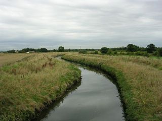
The Glaze Brook, or River Glaze, is a minor river in the River Mersey catchment area, England. From Hope Carr to the River Mersey it forms the county boundary with Cheshire. It is about 22 miles (35 km) long and its main tributaries are the Astley, Bedford, Hey, Pennington, Shaw and Westleigh Brooks.

<span class="mw-page-title-main">Shakerley</span> Human settlement in England

Shakerley is a suburb of Tyldesley in the Metropolitan Borough of Wigan, Greater Manchester, England. It was anciently a hamlet in the northwest of the township of Tyldesley cum Shakerley, in the ancient parish of Leigh. The boundary between Shakerley and Hindsford is the Hindsford Brook. It remains the boundary between Tyldesley and Atherton. Hyndforth Bridge across the brook, was rebuilt in stone in 1629.

<span class="mw-page-title-main">St Mary the Virgin's Church, Leigh</span> Church in Greater Manchester, England

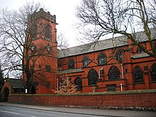
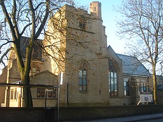
The Parish Church of St Mary the Virgin is a Church of England parish church in Leigh, Greater Manchester, England. It is a member of the Salford & Leigh deanery in the archdeaconry of Salford, diocese of Manchester. It is recorded in the National Heritage List for England as a designated Grade II* listed building.

Leigh was a railway station in Bedford, Leigh, Greater Manchester, England, United Kingdom on the London and North Western Railway. Leigh was in the historic county of Lancashire. Its station opened as Bedford Leigh in 1864, was renamed Leigh & Bedford in 1876 and Leigh in 1914. The station closed in 1969.

<span class="mw-page-title-main">Westleigh, Greater Manchester</span>

Westleigh, a suburb of Leigh, Greater Manchester, England, is one of three ancient townships, Westleigh, Bedford and Pennington, that merged in 1875 to form the borough of Leigh.

Kenyon Junction was a railway station at Kenyon near Culcheth in Warrington, England. The station was built at the junction of the Liverpool and Manchester Railway and the Kenyon and Leigh Junction Railway. It was situated in the historic county of Lancashire. The station opened in 1830 as Bolton Junction and closed to passengers on 2 January 1961 before closing completely on 1 August 1963. The junction fell out of use when the line serving Leigh was closed in 1969.

The Astley and Tyldesley Collieries Company formed in 1900 owned coal mines on the Lancashire Coalfield south of the railway in Astley and Tyldesley, then in the historic county of Lancashire, England. The company became part of Manchester Collieries in 1929 and some of its collieries were nationalised in 1947.

Hindsford Human settlement in England

Hindsford is a suburb of Atherton in the Metropolitan Borough of Wigan, Greater Manchester, England. It is situated to the west of the Hindsford Brook, an ancient boundary between the townships of Atherton and Tyldesley cum Shakerley, and east of the Chanters Brook in the ancient parish of Leigh.

<span class="mw-page-title-main">Pennington, Greater Manchester</span>

Pennington, a suburb of Leigh, Greater Manchester is one of six townships in the ancient ecclesiastical parish of Leigh, that with Westleigh and Bedford merged to form the town of Leigh in 1875. The township of Pennington covered most of Leigh's town centre.

Bedford Colliery, also known as Wood End Pit, was a coal mine on the Manchester Coalfield in Bedford, Leigh, Lancashire, England. The colliery was owned by John Speakman, who started sinking two shafts on land at Wood End Farm in the northeast part of Bedford, south of the London and North Western Railway's Tyldesley Loopline in about 1874. Speakman's father owned Priestners, Bankfield, and Broadoak collieries in Westleigh. Bedford Colliery remained in the possession of the Speakman family until it was amalgamated with Manchester Collieries in 1929.

Leigh Union workhouse, also known as the Leigh workhouse and after 1930, Atherleigh Hospital, was a workhouse built in 1850 by the Leigh Poor Law Union on Leigh Road, Atherton in the historic county of Lancashire.

The Kenyon and Leigh Junction Railway (K&LJR) was constructed to link the Bolton and Leigh Railway (B&LR), which terminated at the Leigh Branch of the Leeds and Liverpool Canal, with the Liverpool and Manchester Railway (L&MR) at Kenyon.

References

  1. 1 2 3 4 Farrer, William; Brownbill, J, eds. (1907), "Bedford", A History of the County of Lancaster: Volume 3, British History Online, pp. 431–435, retrieved 26 August 2010
  2. 1 2 Lunn 1958 , p. 187
  3. Lunn 1958 , p. 215
  4. Lunn 1958 , p. 252
  5. Lunn 1958 , p. 255
  6. Lunn 1958 , p. 256
  7. Lunn 1958 , p. 262
  8. Lunn 1958 , p. 259
  9. Leigh, workhouses.org.uk, retrieved 16 August 2009
  10. Greater Manchester Gazetteer, Greater Manchester County Record Office, archived from the original on 18 July 2011, retrieved 3 June 2010
  11. Lunn 1958 , p. 295
  12. Leigh Borough Council 1953 , p. 26
  13. Sweeney 1996 , p. 63
  14. Ashmore 1982 , p. 103
  15. Historic England, "Bedford St Joseph RC (1068480)", National Heritage List for England , retrieved 27 August 2010
  16. St Thomas History, St Thomas Leigh, archived from the original on 5 May 2013, retrieved 10 January 2013

Bibliography

  • Ashmore, Owen (1982), The Industrial Archaeology Of North-West England, Manchester University Press, ISBN   0-7190-0820-4
  • Leigh Borough Council (1953), Leigh Official Guide, Leigh Borough Council
  • Lunn, John (1958), History of Leigh, Leigh Borough Council
  • Mills, A.D. (1998), Dictionary of English Place-Names, Oxford, ISBN   0-19-280074-4
  • Sweeney, D.J. (1996), A Lancashire Triangle Part One, Triangle Publishing, ISBN   0-9529333-0-6

Coordinates: 53°29′38″N2°29′59″W / 53.4939°N 2.4996°W / 53.4939; -2.4996