Kachhauna Patseni is a town and a nagar panchayat in Sandila tehsil of Hardoi district, Uttar Pradesh, India. It was first upgraded to urban status for the 1981 census. As of 2011, its population is 15,647, in 2,772 households. The Kachhauna community development block encompasses the rural areas surrounding the town.
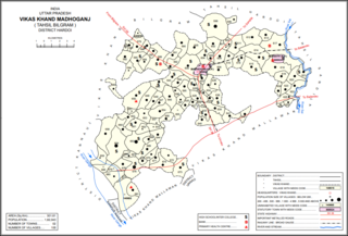
Madhoganj is a town and Nagar Panchayat in Bilgram tehsil of Hardoi district, Uttar Pradesh, India. It is located on the north side of the main road from Sitapur to Kanpur, with other roads leading to Bilgram to the northwest, Mallawan to the south, and Beniganj and Balamau to the east. As of 2011, the population of Madhoganj is 11,523, in 2,180 households. It is also the seat of a community development block.

Todarpur, also spelled Tondarpur, is a village and corresponding community development block in Shahabad tehsil of Hardoi district, Uttar Pradesh, India. The village has several schools and one clinic. It hosts neither a haat nor a mandi. The staple crops here are wheat and rice. As of 2011, its population is 3,846, in 603 households.

Bharkhani is a village and corresponding community development block in Hardoi district of Uttar Pradesh, India. It has several schools, one clinic, and a public library, and there is a regular market as well as a weekly haat. A fair called Banshi Baba is held here on Chaitra Badi 30. The main staple crops here are wheat and rice. As of 2011, the population of Bharkhani is 5,681, in 888 households.

Satautha is a village in Harpalpur block of Hardoi district, Uttar Pradesh, India. The main staple crops here are wheat and rice. As of 2011, the population of Satathua is 3,992, in 727 households. The village lands cover an area of 797.6 hectares.
Kherwa Amjadpur is a village in Sandi block of Hardoi district, Uttar Pradesh, India. It is located 8 km (5.0 mi) away from Sandi, which is the nearest city. The village has one primary school. The main staple crops are wheat and maize. As of 2011, its population is 752, in 231 households.
Dasauli is a village in Sandi block of Hardoi district, Uttar Pradesh, India. It is located 10 km away from Sandi, which is the nearest city. The main staple crops are wheat and rice. As of 2011, its population is 1,950, in 291 households.
Nikari is a village in Sandi block of Hardoi district, Uttar Pradesh, India. It is located 8 km (5.0 mi) away from Sandi, which is the nearest city. The village has one primary school, and the main staple crops are wheat and rice. As of 2011, the population of Nikari is 1,878, in 283 households.
Lamkan is a village in Sandi block of Hardoi district, Uttar Pradesh, India. It is located 6 km away from Sandi, which is the nearest city. It is connected to state and national highways and has a sub post office and two primary schools but no healthcare facilities. The main staple crops are wheat and rice. As of 2011, its population is 3,734, in 577 households.
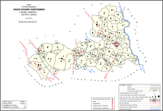
Hariyawan is a village and corresponding community development block in Hardoi district of Uttar Pradesh, India. It hosts a market on Wednesdays and Sundays. The main staple foods here are wheat and rice. As of 2011, its population is 2,997, in 508 households.
Kurseli is a large village in Hariyawan block of Hardoi district, Uttar Pradesh, India. It is located north of the city of Hardoi, to the west of the main road to Pihani. Kurseli hosts a market on Mondays and Thursdays, and the main staple foods are wheat and rice. It has several schools and one clinic, along with five practitioners of traditional medicine. The village lands extend a long way to the south, and include a chain of jhils that ultimately drain into the Sai river. As of 2011, the population of Kurseli is 10,404, in 1,936 households.

Tadiyawan, also spelled Tandiyawan, is a village and corresponding community development block in Hardoi district of Uttar Pradesh, India. Located 14 km from the city of Hardoi, it hosts a regular market and hosts a Deviji festival on Chaitra Sudi 8 dedicated to worship of the goddess Devi. The village has two primary schools but no healthcare facilities. As of 2011, the population of Tadiyawan is 5,998, in 1,079 households.
Asa is a village in Tadiyawan block of Hardoi district, Uttar Pradesh, India. Located 3 km from the city of Hardoi, the village is connected to state highways and has several schools but no healthcare facilities. The main staple foods are wheat and rice. As of 2011, the population of Asa is 5,734, in 944 households.
Pura Bahadur is a village in Tadiyawan block of Hardoi district, Uttar Pradesh, India. Located a few kilometres from the city of Hardoi, the village is connected to state highways and hosts a market on Wednesdays and Sundays. Pura Bahadur has two primary schools and a sub post office. There are no hospitals for humans, although there is a veterinary facility. The main staple foods are wheat and rice. As of 2011, the population of Pura Bahadur is 5,594, in 964 households.
Japra is a village in Tadiyawan block of Hardoi district, Uttar Pradesh, India. Located 16 km from the city of Hardoi, the village is not on any major roads and it has 3 primary schools but no healthcare facilities. The main staple foods are wheat and rice. As of 2011, the population of Japra is 3,633, in 555 households.
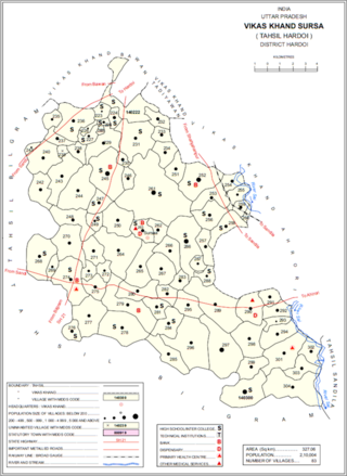
Sursa is a village and corresponding community development block in Hardoi district of Uttar Pradesh, India. Located 14 or 15 km from the city of Hardoi, the village hosts a market on Mondays and Thursdays. The village has two primary schools and one clinic. As of 2011, the population of Sursa is 2,157, in 373 households.
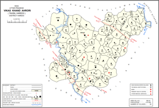
Ahrori, also spelled Ahirori, is a village and corresponding community development block in Hardoi district of Uttar Pradesh, India. Located 24 km from the city of Hardoi, it hosts a regular market and hosts a Babaji festival on Asadha Sudi 15 dedicated to worship of the goddess Devi. The village has two primary schools and one clinic, as well as a public library and a sub post office. As of 2011, the population of Ahrori is 8,382, in 1,329 households.
Kothwan, also spelled Kothawan, is a village and corresponding community development block in Hardoi district of Uttar Pradesh, India. Located 8 km from the city of Beniganj, Kothwan hosts a Parikrma fair during the month of Phalguna where people gather for worship purposes. Vendors bring various items of merchandise to sell at the fair, including carpets, handloom cloth, glassware, earthen pots, toys, and sweets. Kothwan also hosts a market on Wednesdays and Sundays, which involves the sale of miscellaneous products. The main staple foods in Kothwan are wheat and rice. As of 2011, the population of Kothwan is 5,323, in 1,063 households.
Gaju is a village in Kachhauna block of Hardoi district, Uttar Pradesh, India. Located on the road from Balamau station to Beniganj and Sitapur, Gaju has a railway station on the Sitapur-Balamau branch line and hosts a market on Mondays and Thursdays. As of 2011, its population is 8,912, in 1,592 households.

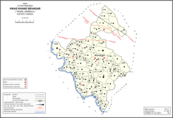
Bharawan is a village and corresponding community development block in Sandila tehsil of Hardoi district, Uttar Pradesh, India. Located 23 km from Sandila, it hosts a market on Mondays and Thursdays and has four primary schools and one healthcare facility. The main staple foods are wheat and juwar. As of 2011, the population of Bharawan is 10,443, in 1,649 households.