Hardoi

Last updated

Hardoi
City
India Uttar Pradesh location map.svg
Red pog.svg
Hardoi
Location in Uttar Pradesh, India
India location map.svg
Red pog.svg
Hardoi
Hardoi (India)
Coordinates: 27°25′N80°07′E / 27.42°N 80.12°E / 27.42; 80.12
CountryFlag of India.svg  India
State Uttar Pradesh
Division Lucknow
District Hardoi
Government
  Type Municipal Council
  BodyHardoi Municipal Council
  Municipal ChairpersonSukhsagar Mishra (BJP) [1] [2]
   Lok Sabha MP Jai Prakash (BJP)
   MLA Nitin Agrawal (BJP)
Elevation
140 m (460 ft)
Population
 (2011) [3]
  Total126,851
Language
  Official Hindi [4]
  Additional official Urdu [4]
Time zone UTC+5:30 (IST)
PIN
241001
Vehicle registration UP-30
Sex ratio 868 /1000
Languages Hindi, Urdu, Awadhi
Website www.hardoi.nic.in

Hardoi is a city and municipal board in Hardoi district in the Indian state of Uttar Pradesh. It is the administrative headquarters of Hardoi district. [5] It is also known as Prahalad Nagari. Hardoi is about 100 km from the state capital Lucknow and about 385 km from New Delhi. Hardoi is a temple town.

Contents

History

The early history of Hardoi is obscure. [6] The name suggests a Bhar, a Dalit caste of pasi origin, but tradition either attributes it to a Thathera ruler named Raja Harnakas or to a religious devotee named Hardeo Babar who supposedly lived here around 1000 CE. [6] In any case, the site was inhabited from an early date; below the old town is an ancient khera that covers 16 acres. [6] Around 1300, a group of Chamar Gaurs led by Nir Singh are said to have conquered the place from the Thatheras, destroyed their fortress, and re-founded the city. [6]

At the turn of the 20th century, Hardoi consisted of two distinct parts: "old" Hardoi, occupying the original site of the village, and "new" Hardoi, which was developed after the establishment of the British civil station in the late 1850s. [6] "New" Hardoi had wide streets, well-shaded by trees, and consisted mostly of the homes of civil officials and members of the local bar, as well as shops. [6] Victoria Hall, built in 1888, contained the municipal and district offices as well as a public library (with books in English, Urdu, Hindi, Persian, Arabic, and Sanskrit) and a clock tower. [6] The city also had a courthouse, police station, dispensary, orphanage, several schools, post and telegraph offices, and jail. [6] Hardoi was not at the time a major commercial centre; the main trade involved gathering grain from the rural parts of the district and then exporting it by rail. [6] There was a grain market at Railwayganj, by the train station, while the main market was at Hardeoganj, which held bazaars on Sundays and Wednesdays. [6] The Gibsonganj quarter, near Railwayganj, had a colony of carpenters who did "extensive business in plough handles, cart wheels, and other portions of country carts." [6]

Geography

Hardoi is located at 27°25′N80°07′E / 27.42°N 80.12°E / 27.42; 80.12 . [7] It has an average elevation of 134 metres (440 ft). Hardoi is located 110 km from Lucknow (capital of Uttar Pradesh) and 394 from New Delhi (capital of India). The Ganges and several of its tributaries are crossing the south of Hardoi district. Its area is 5947 square kilometres. The record height is 500  ft. In 1995, Hardoi district had 5 square kilometres of dense forest and 13 square kilometres of open forest. The length of this district from northwest to southeast is 125.529  km and width from east to west are 74.83  km. District Hardoi comprises five tehsils (Hardoi, Shahabad, Bilgram, Sandila, and Sawayajpur), 19 blocks, 191 Nyay Panchayat, 1101 Gram Sabha, and 1901 inhabited revenue villages. Sandi Bird Sanctuary created in 1990, previously, "Dahar Jheel", is an important ecotourism bird habitat. Gomati river flows mainly in Hardoi.

It also has 7 Nagar Palika Parishads & 6 Nagar Panchayats . Geographical area is 5947 km2. As per census 2011 population of the district is 4091380, out of which Female are 1887116 & Male are 2204264. [8]

Climate

Climate data for Hardoi (1981–2010, extremes 1950–2012)
MonthJanFebMarAprMayJunJulAugSepOctNovDecYear
Record high °C (°F)28.9
(84.0)
34.0
(93.2)
40.6
(105.1)
44.4
(111.9)
47.0
(116.6)
48.3
(118.9)
42.5
(108.5)
39.6
(103.3)
39.5
(103.1)
38.2
(100.8)
34.5
(94.1)
31.8
(89.2)
48.3
(118.9)
Mean daily maximum °C (°F)20.3
(68.5)
24.2
(75.6)
30.3
(86.5)
36.9
(98.4)
38.8
(101.8)
37.9
(100.2)
33.5
(92.3)
32.6
(90.7)
32.2
(90.0)
31.8
(89.2)
28.1
(82.6)
23.2
(73.8)
30.8
(87.4)
Mean daily minimum °C (°F)8.9
(48.0)
11.7
(53.1)
15.9
(60.6)
21.7
(71.1)
25.6
(78.1)
27.4
(81.3)
26.6
(79.9)
26.2
(79.2)
24.9
(76.8)
20.5
(68.9)
14.7
(58.5)
10.3
(50.5)
19.5
(67.1)
Record low °C (°F)0.7
(33.3)
2.2
(36.0)
6.3
(43.3)
12.0
(53.6)
14.8
(58.6)
18.5
(65.3)
14.0
(57.2)
16.0
(60.8)
19.0
(66.2)
11.1
(52.0)
6.1
(43.0)
1.7
(35.1)
0.7
(33.3)
Average rainfall mm (inches)17.1
(0.67)
17.4
(0.69)
9.4
(0.37)
6.1
(0.24)
24.7
(0.97)
89.6
(3.53)
231.6
(9.12)
216.1
(8.51)
196.2
(7.72)
40.9
(1.61)
1.7
(0.07)
10.1
(0.40)
861.0
(33.90)
Average rainy days1.31.30.90.82.04.410.010.37.61.40.40.841.3
Average relative humidity (%) (at 17:30 IST)65554432364772757361596457
Source: India Meteorological Department [9] [10]

Demographics

Religions in Hardoi City (2011) [11]
ReligionPercent
Hinduism
83.13%
Islam
16.06%
Other or not stated
0.81%
Distribution of religions

As of 2011 Indian Census, Hardoi had a total population of 126,851, of which 66,352 were males and 60,499 were females. Population within the age group of 0 to 6 years was 14,048. Hardoi had an average literary rate of 76%, of which male literacy was 79.5% and female literacy was 72.1%. The Scheduled Castes and Scheduled Tribes population was 12,277 and 4 respectively. Hardoi had 21949 households in 2011. [3]

Economy

As of 1971, the economy of Hardoi was described as a hybrid between the service, commercial, and industrial sectors. [12] The main items imported were kerosene oil, cane sugar, and cloth. [12] The main items manufactured were sugar, groundnut oil, and lime. [12] The biggest exports were sugar, groundnut oil, and arhar. [12]

Education

Related Research Articles

<span class="mw-page-title-main">Gorakhpur</span> City in Uttar Pradesh, India

Gorakhpur is a city in the Indian state of Uttar Pradesh, along the banks of the Rapti river in the Purvanchal region. It is situated 272 kilometres east of the state capital, Lucknow. It is the administrative headquarters of Gorakhpur district, North Eastern Railway Zone and Gorakhpur division. The city is home to the Gorakhnath Math, a Gorakhnath temple. The city also has had an Indian Air Force station since 1963. Gita Press, the world's largest publisher of Hindu religious texts like Ramayana and Mahabharat, has been established here since 1926.

<span class="mw-page-title-main">Bahraich</span> City in Uttar Pradesh, India

Bahraich is a city and a municipal board in Bahraich district in the state of Uttar Pradesh, India. Located on the Saryu River, a tributary of the Ghaghara river, Bahraich is 125 kilometres north-east of Lucknow, the state capital. The districts of Barabanki, Gonda, Balrampur, Lakhimpur Kheri, Shravasti and Sitapur share boundaries with Bahraich. A factor which makes this town important is the international border shared with Nepal.

Sitapur is a city and a municipal board in Sitapur district in the state of Uttar Pradesh, India. It is located 90 kilometres north of state capital, Lucknow. The traditional origin for the name is said to be by the King Vikramāditya from Lord Ram's wife Sita.

Ballia is a city with a municipal board in the Indian state of Uttar Pradesh. The eastern boundary of the city lies at the junction of two major rivers, the Ganges and the Ghaghara.The city is situated 140 km (87 mi) east of Varanasi and about 380 km from the state capital Lucknow. It is home to a protected area, the Jai Prakash Narayan bird sanctuary. Ballia is around 4 km (2.5 mi) from Bihar.

<span class="mw-page-title-main">Ambedkar Nagar district</span> District in Uttar Pradesh, India

Ambedkar Nagar is one of the 75 districts of the Indian state of Uttar Pradesh. This district is a part of Ayodhya division in the Awadh region of the state. This district was established on 29 September 1995 by carving out parts of the erstwhile Faizabad district. It was created by the then Chief Minister Mayawati and named in memory of B. R. Ambedkar, who worked for the advancement of the depressed classes. The total area of Ambedkar Nagar district is 2350 Sq. Km.

<span class="mw-page-title-main">Sitapur district</span> District of Uttar Pradesh in India

Sitapur district is one of the districts which is situated in Uttar Pradesh state of India, with Sitapur town as the district headquarters. Sitapur district is a part of Lucknow division.

<span class="mw-page-title-main">Kannauj district</span> District of Uttar Pradesh in India

Kannauj district is an administrative district of Uttar Pradesh state in northern India, along the river Ganges. The historic town of Kannauj, northwest of Kanpur, is the administrative center. The district was carved out of Farrukhabad district on 18 September 1997. The native dialect of this district is Kannauji.

<span class="mw-page-title-main">Hardoi district</span> District of Uttar Pradesh in India

Hardoi district is a district situated in the center of Uttar Pradesh, India. The district headquarters is in the city of Hardoi. Hardoi is the third largest district of Uttar Pradesh. It falls under Lucknow division in the historical region of Awadh State.

<span class="mw-page-title-main">Amroha district</span> District in Uttar Pradesh, India

Amroha is one of the 75 districts of Uttar Pradesh state in northern India. Amroha town is the district headquarters. According to the Government of India, the district is one of the Minority Concentrated Districts on the basis of the 2001 census data on population, socio-economic indicators and basic amenities indicators.

<span class="mw-page-title-main">Lucknow district</span> District of Uttar Pradesh in India

Lucknow district is a district located in the state of Uttar Pradesh in northern India. The city of Lucknow is the district headquarters and the district is part of Lucknow Division. It is also the capital city of Uttar Pradesh. Lucknow is bounded on the east by Barabanki district, on the west by Unnao and Hardoi districts, on the south by Raebareli district and in the north by Sitapur district.

<span class="mw-page-title-main">Unnao district</span> District of Uttar Pradesh in India

Unnao district is a district of Uttar Pradesh state in central India. The city of Unnao is the district headquarters. The district is part of Lucknow Division.

<span class="mw-page-title-main">Kachhauna Patseni</span> City in Uttar Pradesh, India

Kachhauna Patseni is a town and a nagar panchayat in Sandila tehsil of Hardoi district, Uttar Pradesh, India. It was first upgraded to urban status for the 1981 census. As of 2011, its population is 15,647, in 2,772 households. The Kachhauna community development block encompasses the rural areas surrounding the town.

<span class="mw-page-title-main">Madhoganj</span> City in Uttar Pradesh, India

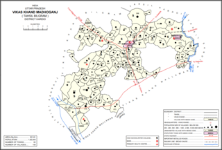
Madhoganj is a town and Nagar Panchayat in Bilgram tehsil of Hardoi district, Uttar Pradesh, India. It is located on the north side of the main road from Sitapur to Kanpur, with other roads leading to Bilgram to the northwest, Mallawan to the south, and Beniganj and Balamau to the east. As of 2011, the population of Madhoganj is 11,523, in 2,180 households. It is also the seat of a community development block.

<span class="mw-page-title-main">Mallawan</span> Town in Uttar Pradesh, India

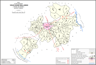
Mallawan, also spelled Mallanwan is a town and Nagar Palika Parishad in Hardoi district of Uttar Pradesh, India. It served as the original district headquarters from 1856 to 1858. It is located south of Bilgram, on the road to Unnao. Mallawan is a major centre of handloom weaving, with handloom cloth being a major export. As of 2011, the population of Mallawan is 36,915, in 6,086 households. It is included in the legislative assembly constituency of Bilgram-Mallanwan.

<span class="mw-page-title-main">Pihani</span> Town in Uttar Pradesh, India

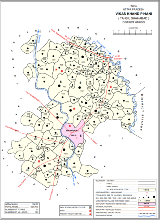
Pihani is a town and nagar palika parishad in Hardoi district of Uttar Pradesh, India. Historically, the city was a centre of sword production, leading to at least one British writer calling it "the Damascus of Oudh". Today, important industries in Pihani include jaggery and woven carpets. As of 2011, the town's population is 36,014, in 5,626 households. Pihani also serves as the headquarters of a community development block in Shahabad tehsil.

<span class="mw-page-title-main">Sandi, Uttar Pradesh</span> City in Uttar Pradesh, India

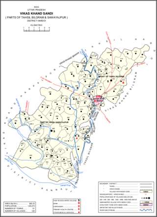
Sandi is a town and a nagar palika parishad in Bilgram tehsil of Hardoi district, Uttar Pradesh, India. It is located on the left bank of the Garra river, on the road from Hardoi to Fatehgarh. As of 2011, its population is 26,007, in 4,396 households.

<span class="mw-page-title-main">Sandila</span> Town in Uttar Pradesh, India

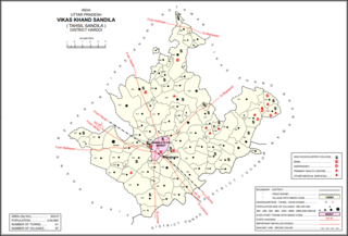
Sandila is a town and nagar palika parishad in Hardoi district in the Indian state of Uttar Pradesh. It serves as a tehsil headquarters within the district. Located midway between Hardoi and Lucknow, Sandila is a well-connected town with roads leading in all directions and a major broad gauge rail line passing through the south side of town. Important industries include sweets — its laddus are especially well-known — as well as beedi production and zardozi work.

<span class="mw-page-title-main">Amethi district</span> District in Uttar Pradesh, India

Amethi is one of the 75 districts of the northern Indian state of Uttar Pradesh. This district is a part of Ayodhya division in the Awadh region of Uttar Pradesh. It covers an area of 2,329.11 km2. Gauriganj is the administrative headquarters of the district.

<span class="mw-page-title-main">Saifai</span> Village in Uttar Pradesh, India

Saifai is a large village and university town in the Etawah district of the Indian state of Uttar Pradesh. It is also a sub-division (Tehsil) and Block of the Etawah district. It is the birthplace of Mulayam Singh Yadav, the founding president of the Samajwadi Party, former Minister of Defence in India, and former Chief Minister of Uttar Pradesh.

<span class="mw-page-title-main">Todarpur, Hardoi</span> Populated place in Uttar Pradesh, India

Todarpur, also spelled Tondarpur, is a village and corresponding community development block in Shahabad tehsil of Hardoi district, Uttar Pradesh, India. The village has several schools and one clinic. It hosts neither a haat nor a mandi. The staple crops here are wheat and rice. As of 2011, its population is 3,846, in 603 households.

References

  1. "2023 UP Municipal Election results". ECI Uttar Pradesh. Retrieved 22 May 2023.
  2. "BJP's Sukhsagar Mishra wins Hardoi". Navbharat Times. Retrieved 23 May 2023.
  3. 1 2 "Census of India: Hardoi". www.censusindia.gov.in. Retrieved 9 October 2019.
  4. 1 2 "52nd Report of the Commissioner for Linguistic Minorities in India" (PDF). nclm.nic.in. Ministry of Minority Affairs. Archived from the original (PDF) on 25 May 2017. Retrieved 24 June 2019.
  5. "Welcome to Official Website of District Court Hardoi". Archived from the original on 3 July 2018. Retrieved 9 October 2019.
  6. 1 2 3 4 5 6 7 8 9 10 11 Nevill, H.R. (1904). Hardoi - A Gazetteer. Allahabad: Government Press. pp. 199–203. Retrieved 22 June 2021.
  7. "Falling Rain Genomics, Inc — Hardoi". Fallingrain.com. Retrieved 10 November 2011.
  8. "Official Website of District Hardoi - Uttar Pradesh".
  9. "Station: Hardoi Climatological Table 1981–2010" (PDF). Climatological Normals 1981–2010. India Meteorological Department. January 2015. pp. 315–316. Archived from the original (PDF) on 5 February 2020. Retrieved 22 September 2020.
  10. "Extremes of Temperature & Rainfall for Indian Stations (Up to 2012)" (PDF). India Meteorological Department. December 2016. p. M216. Archived from the original (PDF) on 5 February 2020. Retrieved 22 September 2020.
  11. "Table C-01 Population by Religion: Uttar Pradesh". censusindia.gov.in. Registrar General and Census Commissioner of India. 2011.
  12. 1 2 3 4 Census 1971 Uttar Pradesh: District Census Handbook Part X-A: Village & Town Directory, District Hardoi (PDF). 1972. pp. viii–xi, 8–9. Retrieved 14 June 2021.
  13. "सेंट जेम्स स्कूल की बीस बसों का चालान". Amar Ujala (in Hindi). 27 April 2017. Retrieved 28 June 2023.
  14. "सेंट जेवियर्स स्कूल में भी मिली फर्जी बस". Amar Ujala (in Hindi). 29 April 2017. Retrieved 28 June 2023.

Commons-logo.svg Media related to Hardoi at Wikimedia Commons