Sultanpur district is a district in the Awadh region of the Indian state of Uttar Pradesh. This district is a part of Ayodhya division of the state. The administrative headquarters of the district is Sultanpur city. The total area of Sultanpur district is 2672.89 Sq. km.

The Bareilly district belongs to the state Uttar Pradesh in northern India. Its capital is Bareilly city and it is divided in six administrative division or tehsils: Aonla, Baheri, Bareilly city, Faridpur, Mirganj, and Nawabganj. The Bareilly district is a part of the Bareilly Division and occupies an area of 4120 km2 with a population of 4,448,359 people according to the census of 2011.

Shahjahanpur is a district of Uttar Pradesh India. It is a part of Bareilly division. It was established in 1813 by the British Government. Previously it was a part of district Bareilly. Geographically the main town is Shahjahanpur which is its headquarters. Its 4 Tehsils are: Powayan, Tilhar, Jalalabad and Sadar.

Saharanpur district is the northernmost of the districts of Uttar Pradesh state, India. Bordering the states of Haryana, Himachal Pradesh and Uttarakhand, and close to the foothills of Shivalik range, it lies in the northern part of the Doab region.
Hardoi district is a district situated in the center of Uttar Pradesh, India. The district headquarters is in the city of Hardoi. Hardoi is the third largest district of Uttar Pradesh. It falls under Lucknow division in the historical region of Awadh State.

Lucknow district is a district located in the state of Uttar Pradesh in northern India. The city of Lucknow is the district headquarters and the district is part of Lucknow Division. It is also the capital city of Uttar Pradesh. Lucknow is bounded on the east by Barabanki district, on the west by Unnao and Hardoi districts, on the south by Raebareli district and in the north by Sitapur district.

Unnao district is a district of Uttar Pradesh state in central India. The city of Unnao is the district headquarters. The district is part of Lucknow Division.

Raebareli district is a district of Uttar Pradesh state in northern India. The city of Raebareli is the district headquarters. This district is a part of Lucknow Division in Uttar Pradesh state. The total area of Raebareli district is 3,371 Sq. km.

Bachhrawan is a town and nagar panchayat in Raebareli district in the state of Uttar Pradesh, India. It is the seat of a community development block. It is located on the main Raebareli-Lucknow road, at the intersection with roads leading to Maharajganj, Haidergarh, and Gurbakhshganj. The railway runs parallel with the Raebareli-Lucknow road, and there is a train station on the west side of town. First upgraded to municipal status in 1935, Bachhrawan hosts a Ramlila festival on Asvina Sudi 10, which involves a dramatic reenactment of the Ramayana. Vendors bring various everyday items to sell at the festival. As of 2011, the population of Bachhrawan is 12,521, in 2,359 households.
Bilgram is a town and a nagar palika parishad in Hardoi district in the state of Uttar Pradesh, India. It is located 16 miles (26 km) south of the city of Hardoi, on an elevated bluff that once formed the eastern bank of the Ganges. Important industries in Bilgram include ceramics and embroidery.
Gopamau is a town and nagar panchayat in Hardoi district, Uttar Pradesh, India. Located just west of the Gomti river, Gopamau is a historic town that once served as a pargana headquarters. Important industries include cap making, tobacco, and agricultural products. As of 2011, the population of Gopamau is 15,526, in 2,346 households. The town has several slum areas, which are home to 36.07% of town residents.
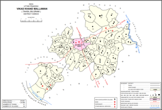
Mallawan, also spelled Mallanwan is a town and Nagar Palika Parishad in Hardoi district of Uttar Pradesh, India. It served as the original district headquarters from 1856 to 1858. It is located south of Bilgram, on the road to Unnao. Mallawan is a major centre of handloom weaving, with handloom cloth being a major export. As of 2011, the population of Mallawan is 36,915, in 6,086 households. It is included in the legislative assembly constituency of Bilgram-Mallanwan.
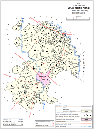
Pihani is a town and nagar palika parishad in Hardoi district of Uttar Pradesh, India. Historically, the city was a centre of sword production, leading to at least one British writer calling it "the Damascus of Oudh". Today, important industries in Pihani include jaggery and woven carpets. As of 2011, the town's population is 36,014, in 5,626 households. Pihani also serves as the headquarters of a community development block in Shahabad tehsil.
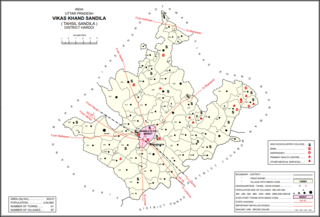
Sandila is a town and nagar palika parishad in Hardoi district in the Indian state of Uttar Pradesh. It serves as a tehsil headquarters within the district. Located midway between Hardoi and Lucknow, Sandila is a well-connected town with roads leading in all directions and a major broad gauge rail line passing through the south side of town. Important industries include sweets — its laddus are especially well-known — as well as beedi production and zardozi work.

Shahabad is a town nearby Hardoi city and a municipal board in Hardoi district in the Indian state of Uttar Pradesh. At one point of time, it was counted among the few biggest cities of Oudh, but declined rapidly in the later years and reduced to a town. It is the site of the tomb of Diler Khan, a governor in the time of Shah Jahan and Aurangzeb.

Balamau is a village in Kachhauna block of Hardoi district, Uttar Pradesh, India. It is located about a mile from the left bank of the Sai river, 25 miles from Hardoi and 4 miles southwest of the namesake Balamau station, which is actually in Kachhauna. Balamau was historically the largest settlement in the area, serving as the seat of a pargana since the reign of Akbar. As of 2011, its population is 4,749, in 1,022 households.
Juggaur or Jugor is a village in Chinhat block, Lucknow district, Uttar Pradesh, India. As of the 2011 Census of India, the population of the village is 9,478, in 1,590 households. The village code is 0297. It is part of Lucknow tehsil. It is the seat of a gram panchayat.
Udhranpur is a village in Shahabad block of Hardoi district, Uttar Pradesh, India. It is located a bit north of Shahabad on the main Hardoi-Shahjahanpur road, just to the east of the river Garra. The village hosts a periodic haat and has several schools and one clinic. As of 2011, its population is 5,021, in 982 households.
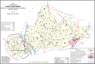
Bawan is a large village and corresponding community development block in Hardoi district of Uttar Pradesh, India. It is located 10 km west of Hardoi, on the south side of the road to Bazpur-Naktaura and the Sai Ghat. Bawan was historically the seat of a pargana since at least the time of the Mughal Emperor Akbar, and it is also the site of a mela held in honour of Darshan Debi on the first Sunday of Bhadon, at a site called the Suraj Kund. The main staple crops here are wheat, rice, and gram. Markets are held on Mondays and Thursdays. As of 2011, the population of Bawan is 13,524, in 2,230 households.

Hardoi is a village in Maharajganj block of Rae Bareli district, Uttar Pradesh, India. Located on the road from Maharajganj to Bachhrawan, Hardoi historically served as the seat of a pargana and has a now-ruined fort built in the early 1400s under the Jaunpur Sultanate. As of 2011, its population is 2,308, in 415 households.
