Hardoi district is a district situated in the center of Uttar Pradesh, India. The district headquarters is in the city of Hardoi. Hardoi is the third largest district of Uttar Pradesh. It falls under Lucknow division in the history region of Awadh

Lucknow district is a district located in the state of Uttar Pradesh in northern India. The city of Lucknow is the district headquarters and the district is part of Lucknow Division. It also is the capital of Uttar Pradesh.

Raebareli district is a district of Uttar Pradesh state in northern India. The city of Raebareli is the district headquarters. This district is a part of Lucknow Division in Uttar Pradesh state. The total area of Raebareli district is 3,371 Sq. km.

Bachhrawan is a town and nagar panchayat in Raebareli district in the state of Uttar Pradesh, India. It is the seat of a community development block. It is located on the main Raebareli-Lucknow road, at the intersection with roads leading to Maharajganj, Haidergarh, and Gurbakhshganj. The railway runs parallel with the Raebareli-Lucknow road, and there is a train station on the west side of town. First upgraded to municipal status in 1935, Bachhrawan hosts a Ramlila festival on Asvina Sudi 10, which involves a dramatic reenactment of the Ramayana. Vendors bring various everyday items to sell at the festival. As of 2011, the population of Bachhrawan is 12,521, in 2,359 households.

Bangarmau is a big city with Tehsil Bangarmau, in the Unnao district, Uttar Pradesh, India. It is located on high ground overlooking the left bank of the Kalyani river, about 50 km northwest of Unnao and 22 km northwest of Safipur. Roads fan out in all directions from Bangarmau, including the main Unnao-Hardoi road that passes through town. Major commodities produced here include wheat flour, rice, and pulses. As of 2011, the population of Bangarmau is 44,204, in 7,600 households.
Bilgram is a town and a nagar palika parishad in Hardoi district in the state of Uttar Pradesh, India. It is located 16 miles (26 km) south of the city of Hardoi, on an elevated bluff that once formed the eastern bank of the Ganges. Important industries in Bilgram include ceramics and embroidery.
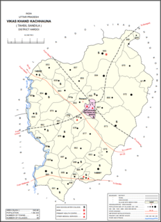
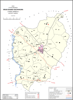
Kachhauna Patseni is a town and a nagar panchayat in Sandila tehsil of Hardoi district, Uttar Pradesh, India. It was first upgraded to urban status for the 1981 census. As of 2011, its population is 15,647, in 2,772 households. The Kachhauna community development block encompasses the rural areas surrounding the town.
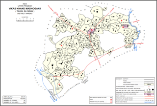
Madhoganj is a city and Nagar Panchayat in Bilgram tehsil of Hardoi district, Uttar Pradesh, India. It is located on the north side of the main road from Sitapur to Kanpur, with other roads leading to Bilgram to the northwest, Mallawan to the south, and Beniganj and Balamau to the east. As of 2011, the population of Madhoganj is 11,523, in 2,180 households. It is also the seat of a community development block.
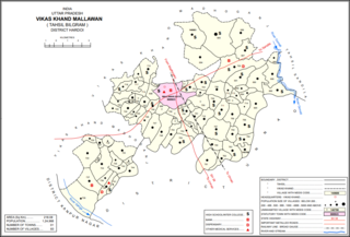
Mallawan, also spelled Mallanwan is a city and Nagar Palika Parishad in Hardoi district of Uttar Pradesh, India. It served as the original district headquarters from 1856 to 1858. It is located south of Bilgram, on the road to Unnao. Mallawan is a major centre of handloom weaving, with handloom cloth being a major export. As of 2011, the population of Mallawan is 36,915, in 6,086 households. It is included in the legislative assembly constituency of Bilgram-Mallanwan.
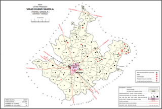
Sandila is a town and nagar palika parishad in Hardoi district in the Indian state of Uttar Pradesh. It serves as a tehsil headquarters within the district. Located midway between Hardoi and Lucknow, Sandila is a well-connected town with roads leading in all directions and a major rail line passing through the south side of town. Important industries include sweets — its laddus are especially well-known — as well as beedi production and zardozi work.
Balamau is a train station in Hardoi district of Lucknow division of Uttar Pradesh. It is located in Kachhauna, four miles northeast of its namesake village of Balamau. It lies on the Amritsar–Pt. Deen Dayal Upadhyaya Junction main line, 9km from the previous station at Baghauli and 8km from the next station at Dalelnagar. It is also the terminus of two branch lines, one leading to Kanpur and the other leading to Sitapur. The Balamau–Kanpur and Balamau–Sitapur lines both use metre-gauge tracks.

Patan is a village in Sumerpur block of Unnao District in the state of Uttar Pradesh, India. It is located 16km south of Purwa on the main Unnao-Allahabad road, and a short distance to the south of the Loni river. Part of the historical region of Baiswara, it historically gave its name to a pargana which existed since at least the time of Akbar, and under the Nawabs of Awadh it was the seat of a tehsil. The Rae Bareli-Kanpur branch of the Northern Railway zone runs through Patan, and the Takia train station is located in the village. A huge fair called the Takia-ka-Mela is held in Patan on the first Thursday in Paus, in honour of the saint Niamat Shah, revered by both Hindus and Muslims, drawing tens of thousands of visitors. A second fair, established by Muhabbat Shah's disciple Shafqat Shah, is also held in Muhabbat Shah's honour at the tomb on the first Thursday of Jeth.

Magrayar is a village in Bighapur block of Unnao district, Uttar Pradesh, India. Located 7km from Bighapur, Magrayar hosts a market on Mondays and Thursdays and was historically the seat of a pargana since at least the late 1500s. As of 2011, Magrayar's population is 4,248, in 964 households.
Bahrauli is a village in Gosainganj block of Lucknow district, Uttar Pradesh, India. In 2011, its population was 5,674 in 1,092 households. It is the seat of a gram panchayat.
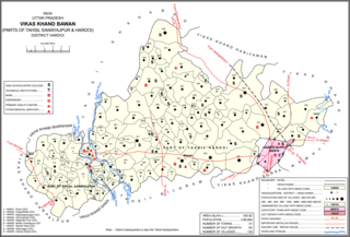
Bawan is a large village and corresponding community development block in Hardoi district of Uttar Pradesh, India. It is located 10km west of Hardoi, on the south side of the road to Bazpur-Naktaura and the Sai Ghat. Bawan was historically the seat of a pargana since at least the time of the Mughal Emperor Akbar, and it is also the site of a mela held in honour of Darshan Debi on the first Sunday of Bhadon, at a site called the Suraj Kund. The main staple crops here are wheat, rice, and gram. Markets are held on Mondays and Thursdays. As of 2011, the population of Bawan is 13,524, in 2,230 households.
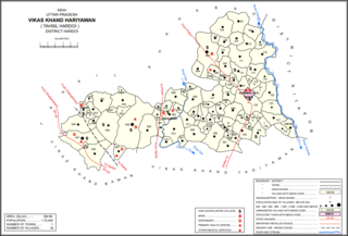
Kurseli is a large village in Hariyawan block of Hardoi district, Uttar Pradesh, India. It is located north of the city of Hardoi, to the west of the main road to Pihani. Kurseli hosts a market on Mondays and Thursdays, and the main staple foods are wheat and rice. It has several schools and one clinic, along with five practitioners of traditional medicine. The village lands extend a long way to the south, and include a chain of jhils that ultimately drain into the Sai river. As of 2011, the population of Kurseli is 10,404, in 1,936 households.
Kalyanmal is a village in Kothwan block of Hardoi district, Uttar Pradesh, India. Historically the seat of a pargana, Kalyanmal is located 11 km from the city of Beniganj, on the north side of the road leading to Atrauli and Bhatpurwaghat. Also close by is the road running from Sandila to Gundlamau in Sitapur district. Every Sunday during the month of Bhadon, a fair is held at Hattia Haran, a tank south of Kalyanmal where the god Rama is said to have bathed. Kalyanmal also hosts a small fair to Panchabgir Mahadeo during the month of Aghan.As of 2011, the population of Kalyanmal is 8,295, in 1,532 households.
Gaju is a village in Kachhauna block of Hardoi district, Uttar Pradesh, India. Located on the road from Balamau station to Beniganj and Sitapur, Gaju has a railway station on the Sitapur-Balamau branch line and hosts a market on Mondays and Thursdays. As of 2011, its population is 8,912, in 1,592 households.

Hardoi is a village in Maharajganj block of Rae Bareli district, Uttar Pradesh, India. Located on the road from Maharajganj to Bachhrawan, Hardoi historically served as the seat of a pargana and has a now-ruined fort built in the early 1400s under the Jaunpur Sultanate. As of 2011, its population is 2,308, in 415 households.

Sarai Kurmi is a village in Lalganj block of Rae Bareli district, Uttar Pradesh, India. It is located 4 km from Lalganj, the block and tehsil headquarters. As of 2011, it has a population of 843 people, in 197 households. It has no healthcare facilities and does not host a permanent market or a weekly haat. It belongs to the nyaya panchayat of Behta Kalan.