Sandi, Uttar Pradesh

Last updated

Sandi, Uttar Pradesh
Sandi
Shantanupuri
City
Sandi block map.png
Map of Sandi CD block
India Uttar Pradesh location map.svg
Red pog.svg
Sandi, Uttar Pradesh
Location in Uttar Pradesh, India
India location map.svg
Red pog.svg
Sandi, Uttar Pradesh
Sandi, Uttar Pradesh (India)
Coordinates: 27°18′N79°57′E / 27.3°N 79.95°E / 27.3; 79.95
CountryFlag of India.svg  India
State Uttar Pradesh
Division Lucknow
District Hardoi
Government
  Type Municipal Council
  BodySandi Municipal Council
  Municipal ChairpersonRamji Gupta [1] (BSP)
   MLA Prabhash Kumar (BJP)
Area
[2]
  Total12.02 km2 (4.64 sq mi)
Elevation
175 m (574 ft)
Population
 (2011)
  Total26,007
  Density2,200/km2 (5,600/sq mi)
Languages
  Official Awadhi, Hindi, Khariboli, Urdu
Time zone UTC+5:30 (IST)
Vehicle registration UP-30

Sandi is a town and a nagar palika parishad in Bilgram tehsil of Hardoi district, Uttar Pradesh, India. [2] It is located on the left bank of the Garra river, on the road from Hardoi to Fatehgarh. [3] As of 2011, its population is 26,007, in 4,396 households. [2]

Contents

Geography

Sandi is located at 27°18′N79°57′E / 27.3°N 79.95°E / 27.3; 79.95 . [4] It has an average elevation of 175 metres (439 feet).

History

The name "Sandi" is said to be derived from the name Santan Dih or Santan Khera, which it received after Raja Santan Singh, a Sombansi king said to have ruled here until 1398, when he was defeated by Muslim conquerors and fled to Kumaon. [3] His fort, whose ruins still exist to the south of the modern town, had a deep moat, and the besieging Muslim army had little success until they dug a channel from the moat to the Garra. [3] The Muslims at first built a town southeast of Santan Khera, called Fatehpur Islamabad, but 22 years later it was abandoned due to disease and the site of Santan Khera was reoccupied. [3] It was officially renamed Ashrafabad, but the name never caught on and instead it was called Santan Dih or Sandi. [3]

Around the turn of the 20th century, the main mahallas were Saiyidwara, Salamullahganj, Munshiganj, Khalisa, Auladganj, Nawabganj, and Uncha Tila. [3] Uncha Tila was the site of an earthwork fortification built by Shuja-ud-Daula in the 1700s, a factory built by Europeans later on, and a chaukidar's fort. [3] Uncha Tila was the site of the tehsil headquarters when Sandi was originally selected as a tehsil by the British, although it was later moved to Bilgram. [3] Nawabganj was the site of the main bazaar in Sandi; smaller ones were held at Khalisa, Auladganj, Munshiganj, and Salamullahganj. [3]

The population of Sandi declined somewhat in the late 1800s, from 11,123 people in 1872 to 9,072 in 1901. [3]

Demographics

Historical population
YearPop.±%
1901 9,072    
1911 7,139−21.3%
1921 6,517−8.7%
1931 6,837+4.9%
1941 7,416+8.5%
1951 7,858+6.0%
1961 9,103+15.8%
1971 11,567+27.1%
1981 15,140+30.9%
1991 18,955+25.2%
2001 23,234+22.6%
2011 26,007+11.9%
Source: 2011 Census of India [2]

As of the 2001 Census of India, [5] Sandi had a population of 12.607. Males constitute 54% of the population and females 46%. Sandi has an average literacy rate of 81%, higher than the national average of 74%: male literacy is 86%, and female literacy is 71%. In Sandi, 17% of the population is under 6 years of age.

As of 2011, the population of Sandi is 26,007, in 4,396 households. [2] Of this, 3,815 (%) is age 0-6. [2] Its sex ratio is 905 females to 1000 males. [2] Among the 0-6 age group, the ratio is 949. [2] The overall literacy rate is 67.65%, including 73.63% among males and 60.97% among females. [2]

Economy

As of 1971, the economy of Sandi was described as a mix of primary activities along with commercial and industrial sectors, with primary activities being the largest category. [6] The main items imported were coal, kerosene oil, and cotton. [6] The main items manufactured were groundnut oil, mustard oil, and power threshers. [6] The biggest exports were grains, potatoes, and groundnut oil. [6]

Sandi Bird Sanctuary

Sandi Bird Sanctuary is located at a distance of 19 km on Hardoi-Sandi Road in Hardoi district of Uttar Pradesh. Sandi Bird Sanctuary is 1 km. from Sandi town on Main Road, Nawabganj, near Sandi Police Station Sandi (Hardoi). Sandi Bird sanctuary was developed in the year 1990 in view to protect the natural habitats and aquatic vegetation for the local residents and migratory birds. The Sandi Bird sanctuary is also known by its ancient name as "Dahar Jheel" (Jheel = Lake). The lake is spread over 3.0854 km2 area. River Garra earlier named as Garun Ganga also located near the sanctuary. Migratory birds rest for sometime in the river front before reaching to Sandi Bird sanctuary. The migratory birds start coming at the beginning of winter in the month of November.

As a tourist destination, Sandi is a paradise for bird lovers and is an ideal place for those who want to explore nature. The best time to visit the sanctuary is from December to February. The nearest railway station is at Hardoi (19 km). From several years the lake was about to dry but after many efforts the lake get its breath again

Villages

Sandi CD block has the following 120 villages: [2]

Village nameTotal land area (hectares)Population (in 2011)
Janiya Mau 164.1512
Bhanapur Sisala 721.61,242
Bhanapur Pansala 35.5307
Bamta Pur Chillaur Sisala 872.74,061
Bamta Pur Chillaur Pansala 130.20
Chhitra Mau Sisala 160.31,802
Chhitra Mau Pansala 354723
Raura 252.21,639
Bhaghar Sisala 103.41,110
Bhaghar Pansala 1850
Taraura 146.71,023
Sathiya Mau Sisala 260.51,608
Sathiya Mau Pansala 47.70
Mani Mau 138.21,636
Barnai Chatarkha 677.14,706
Dhigasar 146739
Nikari 185.71,878
Lamkan 847.83,734
Naya Gaon 486.41,679
Bakhria 280.72,506
Taudhakpur 93.5971
Ghatkana 2521,630
Jalpipur Sisala 55.2462
Jalpipur Pansala 27.3177
Meotha Sisala 24.5849
Meotha Pansala 450
Barauli 58.41,162
Barauli Pansala 22.90
Hari Bansapur Sisala 81.90
Hari Bansapur Pansala 55.11,008
Baran Dari 453.92,194
Chand Saura 299.41,977
Karanpur Matini 247.53,245
Antwa Sisala 124.7770
Antwa Pansala 7.5145
Dei Chor Sisala 73.7644
Dei Chor Pansala 22.70
Gurah 365.41,220
Baithapur 119.71,216
Mahitapur 373.44,790
Karta 2665.81,934
Andramau 207.3544
Kaikhaye 3632,827
Dasauli 654.61,950
Ainda 287.2745
Behtahari 263.5861
Madar 8095,270
Auraini 213.71,519
Behthar 355.71,104
Shekhpur 1641,835
Chausar Sisala 374.54,005
Chausar Pansala 316.20
Semria 4504,330
Banamau 7193,160
Chandrampur Sisala 37.1340
Chandrampur Pansala 348.9833
Katri Chhochhpur 1,970.22,799
Nanndana Sisala 139.71,856
Nanndana Pansala 157.20
Nanndana Barar 42.80
Magraura 121803
Siya Zadid 8.60
Siya Kadim 93.8544
Chandau Bechey 93.31,025
Chandau Bakkha 22.7312
Shrimau 268.74,835
Pura Rohan 35.2506
Chhochhpur 450.72,564
Deokali 33544
Jasmaee 21.2264
Bijna 352.8998
Kuchila 400.44,468
Khimapurva 164.6770
Nonkhara 565.23,855
Madarpur Mohiuddinpur 145.21,086
Mansoorpur 107.71,412
Jigni 1511,059
Tera Pursoli Sisala 146.72,282
Tera Pursoli Pansala 203.1633
Katri Gugrapur 255.70
Katri Chandapur 345.30
Khamdoopur 81.10
Nagra Sahsi 139.5217
Katri Kusum Khor 727.10
Katri Haidarabad 198.30
Umrauli Gangawar 219.30
Umrauli Jaitpur 443.93,989
Narayanpur 583.5110
Katri Umrauli 164.60
Saintiapur 657.43,944
Khutehna 281.12,162
Ullamau 2991,191
Kakerhi 4682,995
Sagaicha Mau 5422,968
Kherwa Amjadpur 159752
Sadullapur 211.51,939
Tebhnapur 93.81,189
Uncha Malwa 143.81
Akhwailpur Malwa 5972,443
Nasirpur 194.5556
Koilaee 3681,696
Adampur 7545,676
Jajwasi 680.53,687
Amilookha 78.7475
Bagh Rai 9313,075
Odara Kadim 40.2527
Odara Jadid 52.155
Rasoolpur Aima 73.21,244
Allipur 79.9323
Sandi (Rural) 136.20
Bhaurajpur 203.9979
Sandi (Rural) Pansala 136.20
Sandi (Rural) Pansala 6581,048
Mirzapur 298.6506
Auhadpur 63.90
Saidapur 368.81,804
Pakra 76.672
Bahadur Nagar 209313
Behti Chiragpur 229.91,024
Ganjari 154.81,076

Related Research Articles

Hardoi is a city and municipal board in Hardoi district in the Indian state of Uttar Pradesh. It is the administrative headquarters of Hardoi district. It is also known as Prahalad Nagari. Hardoi is about 100 km from the state capital Lucknow and about 385 km from New Delhi. Hardoi is a temple town.

<span class="mw-page-title-main">Hardoi district</span> District of Uttar Pradesh in India

Hardoi district is a district situated in the center of Uttar Pradesh, India. The district headquarters is in the city of Hardoi. Hardoi is the third largest district of Uttar Pradesh. It falls under Lucknow division in the historical region of Awadh State.

<span class="mw-page-title-main">Bilgram</span> Town in Uttar Pradesh, India

Bilgram is a town and a nagar palika parishad in Hardoi district in the state of Uttar Pradesh, India. It is located 16 miles (26 km) south of the city of Hardoi, on an elevated bluff that once formed the eastern bank of the Ganges. Important industries in Bilgram include ceramics and embroidery.

<span class="mw-page-title-main">Kachhauna Patseni</span> City in Uttar Pradesh, India

Kachhauna Patseni is a town and a nagar panchayat in Sandila tehsil of Hardoi district, Uttar Pradesh, India. It was first upgraded to urban status for the 1981 census. As of 2011, its population is 15,647, in 2,772 households. The Kachhauna community development block encompasses the rural areas surrounding the town.

<span class="mw-page-title-main">Madhoganj</span> City in Uttar Pradesh, India

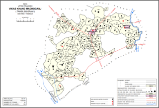
Madhoganj is a town and Nagar Panchayat in Bilgram tehsil of Hardoi district, Uttar Pradesh, India. It is located on the north side of the main road from Sitapur to Kanpur, with other roads leading to Bilgram to the northwest, Mallawan to the south, and Beniganj and Balamau to the east. As of 2011, the population of Madhoganj is 11,523, in 2,180 households. It is also the seat of a community development block.

<span class="mw-page-title-main">Mallawan</span> Town in Uttar Pradesh, India

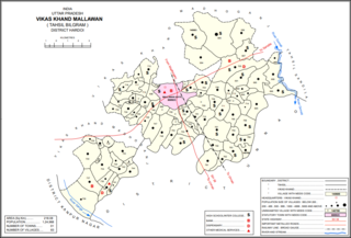
Mallawan, also spelled Mallanwan is a town and Nagar Palika Parishad in Hardoi district of Uttar Pradesh, India. It served as the original district headquarters from 1856 to 1858. It is located south of Bilgram, on the road to Unnao. Mallawan is a major centre of handloom weaving, with handloom cloth being a major export. As of 2011, the population of Mallawan is 36,915, in 6,086 households. It is included in the legislative assembly constituency of Bilgram-Mallanwan.

Pali is a town and nagar panchayat in Sawayajpur tehsil of Hardoi district, Uttar Pradesh, India. It is on the right bank of the Garra river, 20 miles northwest of Hardoi, Pali historically served as the seat of a pargana and was a regional political headquarters under the Nawabs of Awadh. The town's name is possibly connected to the Pal dynasty that once ruled the nearby city of Kannauj. As of 2011, the population of Pali is 18,708 in 2,949 households.

<span class="mw-page-title-main">Shahabad, Hardoi</span> City in Uttar Pradesh, India

Shahabad is a town nearby Hardoi city and a municipal board in Hardoi district in the Indian state of Uttar Pradesh. At one point of time, it was counted among the few biggest cities of Oudh, but declined rapidly in the later years and reduced to a town. It is the site of the tomb of Diler Khan, a governor in the time of Shah Jahan and Aurangzeb.

<span class="mw-page-title-main">Nawabganj, Unnao</span> Nagar panchayat in Uttar Pradesh, India

Nawabganj is a town and nagar panchayat in Hasanganj tehsil of Unnao district, Uttar Pradesh, India. It is located northeast of Unnao on the Lucknow-Kanpur road, near the Ajgain railway station. Founded in 1842 and first officially classified as a town for the 1981 census, Nawabganj once served as the seat of a tehsil under the Nawabs of Awadh and is today the headquarters of a community development block containing 124 villages.

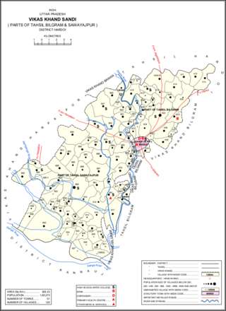
Sandi Bird Sanctuary is a bird sanctuary in Hardoi district of Uttar Pradesh, India.

<span class="mw-page-title-main">Balamau</span> Village in Uttar Pradesh, India

Balamau is a village in Kachhauna block of Hardoi district, Uttar Pradesh, India. It is located about a mile from the left bank of the Sai river, 25 miles from Hardoi and 4 miles southwest of the namesake Balamau station, which is actually in Kachhauna. Balamau was historically the largest settlement in the area, serving as the seat of a pargana since the reign of Akbar. As of 2011, its population is 4,749, in 1,022 households.

<span class="mw-page-title-main">Udhranpur</span> Populated place in Uttar Pradesh, India

Udhranpur is a village in Shahabad block of Hardoi district, Uttar Pradesh, India. It is located a bit north of Shahabad on the main Hardoi-Shahjahanpur road, just to the east of the river Garra. The village hosts a periodic haat and has several schools and one clinic. As of 2011, its population is 5,021, in 982 households.

<span class="mw-page-title-main">Todarpur, Hardoi</span> Populated place in Uttar Pradesh, India

Todarpur, also spelled Tondarpur, is a village and corresponding community development block in Shahabad tehsil of Hardoi district, Uttar Pradesh, India. The village has several schools and one clinic. It hosts neither a haat nor a mandi. The staple crops here are wheat and rice. As of 2011, its population is 3,846, in 603 households.

<span class="mw-page-title-main">Harpalpur, Hardoi</span> Populated place in Uttar Pradesh, India

Harpalpur is a village and corresponding community development block in Sawayajpur tehsil of Hardoi district, Uttar Pradesh, India. It is located west of Sandi, on the road to Fatehgarh. The main staple crops here are wheat, rice, and maize. Markets are held twice weekly. As of 2011, the population of Harpalpur is 8,822, in 1,544 households. The total block population is 172,224, in 29,232 households.

<span class="mw-page-title-main">Khasaura</span> Populated place in Uttar Pradesh, India

Khasaura is a large village in Harpalpur block of Hardoi district, Uttar Pradesh, India. It lies on the left bank of the Ramganga river, to the north of the road connecting Hardoi and Sandi with Farrukhabad. The village hosts a large market twice per week, on Wednesdays and Sundays. It deals mainly in vegetables.

<span class="mw-page-title-main">Kherwa Amjadpur</span> Populated place in Uttar Pradesh, India

Kherwa Amjadpur is a village in Sandi block of Hardoi district, Uttar Pradesh, India. It is located 8 km (5.0 mi) away from Sandi, which is the nearest city. The village has one primary school. The main staple crops are wheat and maize. As of 2011, its population is 752, in 231 households.

<span class="mw-page-title-main">Dasauli</span> Populated place in Uttar Pradesh, India

Dasauli is a village in Sandi block of Hardoi district, Uttar Pradesh, India. It is located 10 km away from Sandi, which is the nearest city. The main staple crops are wheat and rice. As of 2011, its population was 1,950, in 291 households.

<span class="mw-page-title-main">Nikari</span> Populated place in Uttar Pradesh, India

Nikari is a village in Sandi block of Hardoi district, Uttar Pradesh, India. It is located 8 km (5.0 mi) away from Sandi, which is the nearest city. The village has one primary school, and the main staple crops are wheat and rice. As of 2011, the population of Nikari is 1,878, in 283 households.

<span class="mw-page-title-main">Lamkan</span> Populated place in Uttar Pradesh, India

Lamkan is a village in Sandi block of Hardoi district, Uttar Pradesh, India. It is located 6 km away from Sandi, which is the nearest city. It is connected to state and national highways and has a sub post office and two primary schools but no healthcare facilities. The main staple crops are wheat and rice. As of 2011, its population is 3,734, in 577 households.

References

  1. "2023 UP Municipal Election results". ECI Uttar Pradesh. Retrieved 22 May 2023.
  2. 1 2 3 4 5 6 7 8 9 10 "Census of India 2011: Uttar Pradesh District Census Handbook - Hardoi, Part A (Village and Town Directory)" (PDF). Census 2011 India. pp. 32–34, 41, 231–55, 578–81, 589. Retrieved 31 May 2021.
  3. 1 2 3 4 5 6 7 8 9 10 Nevill, H.R. (1904). Hardoi - A Gazetteer. Allahabad: Government Press. pp. 242–5. Retrieved 31 May 2021.
  4. Falling Rain Genomics, Inc - Sandi
  5. "Census of India 2001: Data from the 2001 Census, including cities, villages and towns (Provisional)". Census Commission of India. Archived from the original on 16 June 2004. Retrieved 1 November 2008.
  6. 1 2 3 4 Census 1971 Uttar Pradesh: District Census Handbook Part X-A: Village & Town Directory, District Hardoi (PDF). 1972. pp. viii–xi, 8–9. Retrieved 14 June 2021.

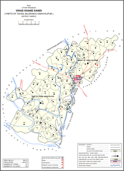
Many battles between the Mogul and Afghan empires took place in town Sandi due to the situation of the town. Humayun was defeated by Sher Shah Suri between the cities of Bilgram and Sandi, and he escaped by crossing the river Ganges with the help of a bhisti to whom he had made the king for one day after regaining the throne.