Belmont, Maine

Last updated

Belmont, Maine
Waldo County Maine Incorporated Areas Belmont Highlighted.png
Location of Belmont (in yellow) in Waldo County and the state of Maine
Coordinates: 44°22′34″N69°6′47″W / 44.37611°N 69.11306°W / 44.37611; -69.11306
Country United States
State Maine
County Waldo
Area
[1]
  Total14.19 sq mi (36.75 km2)
  Land13.61 sq mi (35.25 km2)
  Water0.58 sq mi (1.50 km2)
Elevation
249 ft (76 m)
Population
 (2020)
  Total976
  Density72/sq mi (27.7/km2)
Time zone UTC-5 (Eastern (EST))
  Summer (DST) UTC-4 (EDT)
ZIP code
04952
Area code 207
FIPS code 23-04125
GNIS feature ID0582349
Website Town of Belmont

Belmont is a town in Waldo County, Maine, United States. The population was 976 at the 2020 census. [2] It was originally known as Green Plantation. The squatters who lived there would, when alerted to the impending arrival of law officers, dress as Indians and then ignore the officers. [3]

Contents

Geography

According to the United States Census Bureau, the town has a total area of 14.19 square miles (36.75 km2), of which 13.61 square miles (35.25 km2) is land and 0.58 square miles (1.50 km2) is water, chiefly Tilden Pond (357 acres). [1]

The town is crossed by SR 3 and SR 131. It is bordered by Morrill on the north, Belfast on the east, Northport on the southeast, Lincolnville on the south and Searsmont on the west.

Demographics

Historical population
CensusPop.Note
1820 744
1830 1,04240.1%
1840 1,37832.2%
1850 1,4867.8%
1860 686−53.8%
1870 628−8.5%
1880 520−17.2%
1890 475−8.7%
1900 352−25.9%
1910 335−4.8%
1920 250−25.4%
1930 227−9.2%
1940 213−6.2%
1950 25821.1%
1960 29514.3%
1970 34918.3%
1980 52049.0%
1990 65225.4%
2000 82125.9%
2010 94214.7%
2020 9763.6%
U.S. Decennial Census [4]

2010 census

As of the census [5] of 2010, there were 942 people, 405 households, and 252 families living in the town. The population density was 69.2 inhabitants per square mile (26.7/km2). There were 462 housing units at an average density of 33.9 per square mile (13.1/km2). The racial makeup of the town was 97.0% White, 0.2% African American, 0.3% Native American, 0.3% Asian, 0.8% from other races, and 1.3% from two or more races. Hispanic or Latino of any race were 0.8% of the population.

There were 405 households, of which 28.9% had children under the age of 18 living with them, 47.9% were married couples living together, 9.4% had a female householder with no husband present, 4.9% had a male householder with no wife present, and 37.8% were non-families. 30.4% of all households were made up of individuals, and 14.3% had someone living alone who was 65 years of age or older. The average household size was 2.33 and the average family size was 2.87.

The median age in the town was 44.8 years. 20.8% of residents were under the age of 18; 5.8% were between the ages of 18 and 24; 23.8% were from 25 to 44; 32.2% were from 45 to 64; and 17.6% were 65 years of age or older. The gender makeup of the town was 47.6% male and 52.4% female.

2000 census

As of the census [6] of 2000, there were 821 people, 336 households, and 243 families living in the town. The population density was 60.3 inhabitants per square mile (23.3/km2). There were 393 housing units at an average density of 28.9 per square mile (11.2/km2). The racial makeup of the town was 98.66% White, 0.49% Native American, and 0.85% from two or more races.

There were 336 households, out of which 26.2% had children under the age of 18 living with them, 58.9% were married couples living together, 9.2% had a female householder with no husband present, and 27.4% were non-families. 22.9% of all households were made up of individuals, and 10.7% had someone living alone who was 65 years of age or older. The average household size was 2.44 and the average family size was 2.79.

In the town, the population was spread out, with 23.5% under the age of 18, 7.2% from 18 to 24, 26.6% from 25 to 44, 28.1% from 45 to 64, and 14.6% who were 65 years of age or older. The median age was 40 years. For every 100 females, there were 98.8 males. For every 100 females age 18 and over, there were 93.8 males.

The median income for a household in the town was $29,013, and the median income for a family was $36,875. Males had a median income of $25,197 versus $24,327 for females. The per capita income for the town was $14,942. About 6.3% of families and 10.3% of the population were below the poverty line, including 10.3% of those under age 18 and 13.7% of those age 65 or over.

Notable person

Related Research Articles

<span class="mw-page-title-main">Eagle Lake, Maine</span> Town in the state of Maine, United States

Eagle Lake is a town in Aroostook County, Maine, United States. The population was 772 at the 2020 census. The town was named by a body of troops heading from Bangor to the Aroostook War for the many eagles that they saw around the lake. A total of 49.0% of the population speaks French, reflecting a trend in Northeastern Maine.

<span class="mw-page-title-main">Grand Isle, Maine</span> Town in the state of Maine, United States

Grand Isle is a town in Aroostook County, Maine, United States. The population was 366 at the 2020 census. The village of Grand Isle is in the northwestern part of the town.

<span class="mw-page-title-main">Littleton, Maine</span> Town in the state of Maine, United States

Littleton is a town in Aroostook County, Maine, United States. The population was 997 at the 2020 census.

<span class="mw-page-title-main">Mapleton, Maine</span> Town in the state of Maine, United States

Mapleton is a town in Aroostook County, Maine, United States. The population was 1,886 at the 2020 census.

<span class="mw-page-title-main">Perham, Maine</span> Town in the state of Maine, United States

Perham is a town in Aroostook County, Maine, United States. The population was 371 at the 2020 census. The town was named after Maine's 33rd governor, Sidney Perham.

<span class="mw-page-title-main">Sherman, Maine</span> Town in the state of Maine, United States

Sherman is a town in Aroostook County, Maine, United States. The population was 815 at the 2020 census.

<span class="mw-page-title-main">St. Francis, Maine</span> Town in the state of Maine, United States

St. Francis is a town in Aroostook County, Maine, United States on the Canada–United States border at the junction of the St. Francis River and the Saint John River. The population was 438 at the 2020 census. First settled by English speakers from southern Maine, the original population has been supplanted by French-speaking Acadians.

<span class="mw-page-title-main">Stockholm, Maine</span> Town in the state of Maine, United States

Stockholm is a town in Aroostook County, Maine, United States. The population was 250 at the 2020 census.

<span class="mw-page-title-main">Wade, Maine</span> Town in the state of Maine, United States

Wade is a town in Aroostook County, Maine, United States. The population was 229 at the 2020 census.

<span class="mw-page-title-main">Penobscot, Maine</span> Town in the state of Maine, United States

Penobscot is a town in Hancock County, Maine, United States. The Bagaduce River flows through the town. The population was 1,136 at the 2020 census.

<span class="mw-page-title-main">Manchester, Maine</span> Town in Maine, United States

Manchester is a town in Kennebec County, Maine, United States, located at 44.33°N 69.87°W. The population was 2,456 at the 2020 census. The southern part of the town bordering Cobbosseecontee Lake is a popular recreation spot in central Maine, and part of the Winthrop Lakes Region. Manchester is included in the Augusta, Maine micropolitan and included in the Lewiston-Auburn, Maine metropolitan New England City and Town Area.

Stoneham is a town in Oxford County, Maine, United States. The population was 261 at the 2020 census.

<span class="mw-page-title-main">Upton, Maine</span> Town in the state of Maine, United States

Upton is a town in Oxford County, Maine, United States. The population was 69 at the 2020 census.

Bradley is a town in Penobscot County, Maine, United States. It is part of the Bangor Metropolitan Statistical Area. The population was 1,532 at the 2020 census. The village of Bradley is in the northwestern corner of the town.

<span class="mw-page-title-main">Smithfield, Maine</span> Town in the state of Maine, United States

Smithfield is a town in Somerset County, Maine, United States. The population was 925 at the 2020 census. The town was incorporated on February 29, 1840, making it the only town in Maine incorporated on Leap Day. The town was named after the Rev. Henry Smith, an early settler.

<span class="mw-page-title-main">Searsmont, Maine</span> Town in the state of Maine, United States

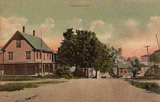
Searsmont is a town in Waldo County, Maine, United States. The population was 1,400 at the 2020 census.

<span class="mw-page-title-main">Cutler, Maine</span> Town in the state of Maine, United States

Cutler is a town in Washington County, Maine, United States. The town was named after Joseph Cutler, an early settler, who hailed from Newburyport, Massachusetts. The population was 524 at the 2020 census.

<span class="mw-page-title-main">Belmont, West Virginia</span> Town in West Virginia, United States

Belmont is a town in Pleasants County, West Virginia, United States. It is part of the Parkersburg–Vienna metropolitan area. The population was 872 at the 2020 census. Belmont was incorporated on April 19, 1946 by the Circuit Court of Pleasants County. The city was named for the beautiful hills in the area.

Belmont is a town in Lafayette County, Wisconsin, United States. The population was 767 at the 2010 census, up from 676 at the 2000 census. The village of Belmont is located in the southeastern part of the town. The unincorporated community of Leslie close to the center of the town.

<span class="mw-page-title-main">East Millinocket, Maine</span> Town in the state of Maine, United States

East Millinocket is a town in Penobscot County, Maine, United States. The population was 1,572 at the 2020 census.

References

  1. 1 2 "US Gazetteer files 2010". United States Census Bureau . Retrieved December 16, 2012.
  2. "Census - Geography Profile: Belmont town, Waldo County, Maine" . Retrieved January 22, 2022.
  3. Maine League of Historical Societies and Museums (1970). Doris A. Isaacson (ed.). Maine: A Guide 'Down East'. Rockland, Me: Courier-Gazette, Inc. p. 161.
  4. "Census of Population and Housing". Census.gov. Retrieved June 4, 2015.
  5. "U.S. Census website". United States Census Bureau . Retrieved December 16, 2012.
  6. "U.S. Census website". United States Census Bureau . Retrieved January 31, 2008.

https://lists.h-net.org/cgi-bin/logbrowse.pl?trx=vx&list=h-women&month=0506&week=c&msg=4pyNptmnzTAHjikGHtYX1Q&user=&pw=