Lincolnville, Maine

Last updated

Lincolnville, Maine
Centennial celebration at Lincolnville, Maine (1902).jpg
Centennial celebration in 1902
Waldo County Maine Incorporated Areas Lincolnville Highlighted.png
Location of Lincolnville (in yellow) in Waldo County and the state of Maine
Coordinates: 44°17′41″N69°4′47″W / 44.29472°N 69.07972°W / 44.29472; -69.07972
Country United States
State Maine
County Waldo
Incorporated 1802
Government
   Select Board Ladleah Dunn, Chair
Keryn Laite, Jr., Vice Chair
Mike Ray
Stephen Hand
Robyn Tarantino
  Town AdministratorDavid B. Kinney [1]
Area
[2]
  Total43.65 sq mi (113.05 km2)
  Land37.34 sq mi (96.71 km2)
  Water6.31 sq mi (16.34 km2)
Elevation
230 ft (70 m)
Population
 (2020)
  Total2,312
  Density62/sq mi (23.9/km2)
Time zone UTC-5 (Eastern (EST))
  Summer (DST) UTC-4 (EDT)
ZIP code
04849
Area code 207
FIPS code 23-39755
GNIS feature ID0582561
Website town.lincolnville.me.us

Lincolnville is a town in Waldo County, Maine, United States. The population was 2,312 at the 2020 census. [3] Lincolnville is the mainland terminal for Maine State Ferry Service transport to Islesboro.

Contents

History

Lincolnville shoreline c. 1880 Lincolnville. Looking north, by H. A. Mills.jpg
Lincolnville shoreline c.1880

Approximately 10,000 years ago, a glacier covered the area to a depth of several thousand feet, carving irregular landforms that survive today. The earliest artifact of European origin was fragments of a 16501660 clay pipe, probably a trade good with the native population. First settled in 1770 by Nathan Knight, the town was incorporated in 1802 from Canaan and Ducktrap plantations. [4] It was named for General Benjamin Lincoln, a Revolutionary War General—second-in-command to George Washington at Yorktown—and friend of Henry Knox. [5]

In an 1807 vote to separate from Massachusetts, it was one of three coastal communities to push for separation (with Bath and Brunswick). [6]

On October 22, 1844, local members of the Millerite sect climbed Megunticook Mountain to await the end of the world and the Second Coming. The event was dubbed the Great Disappointment. They hadn't prepared for the winter, so other Lincolnville residents housed them to help them survive the winter months. [4]

The first school in Lincolnville was a three-sided log cabin behind Nathan Knight's home with a perpendicular ledge for a fourth wall; the ledge served to support a blackboard.

Lamb School was one of the other earlier schools in Lincolnville owned by the Lamb family. It closed in 1912. A sign put up by the Lincolnville Historical Society is now in its place.

Over the years, the population continued to grow until it was incorporated in 1802. A bicentennial celebration was celebrated by the town in 2002. [7]

Geography

According to the United States Census Bureau, the town has a total area of 43.65 square miles (113.05 km2), of which 37.34 square miles (96.71 km2) is land and 6.31 square miles (16.34 km2) is water. [2] Located along the western side of Penobscot Bay, Lincolnville is drained by the Ducktrap River. Principal bodies of water include Megunticook Lake, Norton Pond (123 acres), Coleman Pond (225 acres), Moody Pond (61 acres), and Levenseller Pond (34 acres).

The town is served by U.S. Route 1, and Maine State Routes 173, 52 , and 235. It is bordered by Belmont on the north, Northport on the northeast, Penobscot Bay on the east, Camden on the south, Hope on the west and Searsmont on the northwest.

Demographics

Historical population
CensusPop.Note
1810 1,013
1820 1,29427.7%
1830 1,70231.5%
1840 2,04820.3%
1850 2,1746.2%
1860 2,075−4.6%
1870 1,900−8.4%
1880 1,705−10.3%
1890 1,361−20.2%
1900 1,223−10.1%
1910 1,020−16.6%
1920 811−20.5%
1930 8180.9%
1940 8929.0%
1950 881−1.2%
1960 867−1.6%
1970 95510.1%
1980 1,41448.1%
1990 1,80927.9%
2000 2,04212.9%
2010 2,1646.0%
2020 2,3126.8%
U.S. Decennial Census [8]

2010 census

As of the census [9] of 2010, there were 2,164 people, 959 households, and 635 families living in the town. The population density was 58.0 inhabitants per square mile (22.4/km2). There were 1,465 housing units at an average density of 39.2 per square mile (15.1/km2). The racial makeup of the town was 97.9% White, 0.3% African American, 0.3% Native American, 0.4% Asian, 0.1% Pacific Islander, and 0.9% from two or more races. Hispanic or Latino people of any race were 0.8% of the population.

There were 959 households, of which 25.4% had children under the age of 18 living with them, 55.1% were married couples living together, 6.9% had a female householder with no husband present, 4.3% had a male householder with no wife present, and 33.8% were non-families. 26.1% of all households were made up of individuals, and 10.1% had someone living alone who was 65 years of age or older. The average household size was 2.26 and the average family size was 2.70.

The median age in the town was 47.5 years. 19.7% of residents were under the age of 18; 5.2% were between the ages of 18 and 24; 21.5% were from 25 to 44; 35.8% were from 45 to 64; and 17.7% were 65 years of age or older. The gender makeup of the town was 50.8% male and 49.2% female.

2000 census

As of the census [10] of 2000, there were 2,042 people, 846 households, and 605 families living in the town. The population density was 54.6 inhabitants per square mile (21.1/km2). There were 1,272 housing units at an average density of 34.0 per square mile (13.1/km2). The racial makeup of the town was 98.78% White, 0.05% African American, 0.15% Native American, 0.20% Asian, 0.05% Pacific Islander, 0.39% from other races, and 0.39% from two or more races. Hispanic or Latino people of any race were 0.83% of the population.

There were 846 households, out of which 31.7% had children under the age of 18 living with them, 61.7% were married couples living together, 6.5% had a female householder with no husband present, and 28.4% were non-families. 22.9% of all households were made up of individuals, and 9.5% had someone living alone who was 65 years of age or older. The average household size was 2.41 and the average family size was 2.82.

In the town, the population was spread out, with 23.1% under the age of 18, 4.9% from 18 to 24, 28.2% from 25 to 44, 29.8% from 45 to 64, and 14.0% who were 65 years of age or older. The median age was 42 years. For every 100 females, there were 99.8 males. For every 100 females age 18 and over, there were 98.0 males.

The median income for a household in the town was $42,273, and the median income for a family was $48,500. Males had a median income of $32,006 versus $28,077 for females. The per capita income for the town was $21,621. About 7.0% of families and 9.1% of the population were below the poverty line, including 9.8% of those under age 18 and 9.5% of those age 65 or over.

Education

Lincolnville is part of School Union 69 (with the Towns of Hope and Appleton), which operates the Lincolnville Central School (LCS), for grades preK–8 and is part of the Five Town Consolidated School District (with the towns of Hope, Appleton, Rockport and Camden), which operates Camden Hills Regional High School. Kate Clark is the Superintendent of School Union 69 [11] and Maria Libby is the Superintendent of the Five Town CSD. [12] The principal of LCS is Justin Bennett as of the 2023-2024 school year. [13]

Notable people

Panoramic view of Lincolnville Beach, July 31, 2006 Lincolnville Beach.jpg
Panoramic view of Lincolnville Beach, July 31, 2006

Related Research Articles

<span class="mw-page-title-main">Friendship, Maine</span> Town in the state of Maine, United States

Friendship is a town in Knox County, Maine, United States. It is 31 miles (49.9 km) southeast of Augusta. The population was 1,142 at the 2020 census.

<span class="mw-page-title-main">Hope, Maine</span> Town in Maine, United States

Hope is a town in Knox County, Maine, United States. The population was 1,698 at the 2020 census.

<span class="mw-page-title-main">Rockport, Maine</span> Town in Maine, United States

Rockport is a town in Knox County, Maine, United States. It is 35 miles southeast of Augusta. The population was 3,644 at the 2020 census. Rockport is a popular tourist destination and art colony.

<span class="mw-page-title-main">Union, Maine</span> Town in the state of Maine, United States

Union is a town in Knox County, Maine, United States. The population was 2,383 at the 2020 census. It is home to the Matthews Museum of Maine Heritage and annual Union Fair.

Sweden is a town in Oxford County, Maine, United States. The population was 406 at the 2020 census. Set among hills, forests and ponds, Sweden includes the village of East Sweden.

<span class="mw-page-title-main">Belmont, Maine</span> Town in the state of Maine, United States

Belmont is a town in Waldo County, Maine, United States. The population was 976 at the 2020 census. It was originally known as Green Plantation. The squatters who lived there would, when alerted to the impending arrival of law officers, dress as Indians and then ignore the officers.

<span class="mw-page-title-main">Burnham, Maine</span> Town in the state of Maine, United States

Burnham is a town in Waldo County, Maine, United States. The population was 1,096 at the 2020 census.

<span class="mw-page-title-main">Freedom, Maine</span> Town in the state of Maine, United States

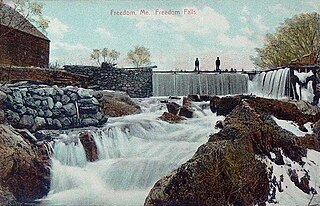
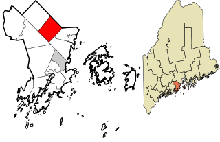
Freedom is a town in Waldo County, Maine, United States. The population was 711 at the 2020 census. Freedom is a residential and recreational area.

<span class="mw-page-title-main">Islesboro, Maine</span> Town in Waldo County, Maine, United States

Islesboro is a town in Waldo County, Maine, United States, comprising Islesboro Island and several smaller islands. The population was 583 at the 2020 census. It has a summer colony accessible by state ferry service from Lincolnville Beach three miles to the west, by private boat, or by air taxi service. Home to Warren Island State Park, Islesboro includes the village of Dark Harbor.

<span class="mw-page-title-main">Jackson, Maine</span> Town in the state of Maine, United States

Jackson is a town in Waldo County, Maine, United States. The town was named after General Henry Jackson of the Revolutionary War. The population was 610 at the 2020 census.

<span class="mw-page-title-main">Monroe, Maine</span> Town in the state of Maine, United States

Monroe is a town in Waldo County, Maine, United States named for President James Monroe. The population was 931 at the 2020 census.

<span class="mw-page-title-main">Morrill, Maine</span> Town in the state of Maine, United States

Morrill is a town in Waldo County, Maine, United States. The population was 971 at the 2020 census.

<span class="mw-page-title-main">Palermo, Maine</span> Town in Maine, United States

Palermo is a town in Waldo County, Maine, United States. The population was 1,570 at the 2020 census. Palermo is included in the Augusta, Maine, micropolitan New England City and Town Area.

<span class="mw-page-title-main">Searsmont, Maine</span> Town in the state of Maine, United States

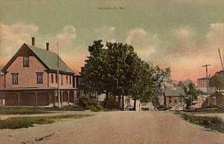
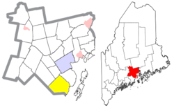
Searsmont is a town in Waldo County, Maine, United States. The population was 1,400 at the 2020 census.

<span class="mw-page-title-main">Waldo, Maine</span> Town in the state of Maine, United States

Waldo is a town in Waldo County, Maine, United States. The population was 795 at the 2020 census. It is the home town of Heather Hemmens, who is known for her role on Hellcats.

<span class="mw-page-title-main">Lincolnville, South Carolina</span> Town in South Carolina, United States

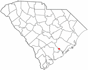
Lincolnville is a town in Charleston County, South Carolina, United States. A very small portion of the town extends into Dorchester County. The population was 1,139 at the 2010 census, up from 904 in 2000.

<span class="mw-page-title-main">Camden, Maine</span> Town in Maine, United States. 04843

Camden is a town in Knox County, Maine, United States. The population was 5,232 at the 2020 census. The population of the town more than triples during the summer months, due to tourists and summer residents. Camden is a summer colony in the Mid-Coast region of Maine. Similar to Bar Harbor, Nantucket and North Haven, Camden is well known for its summer community of wealthy Northeasterners, mostly from Boston, New York City, and Philadelphia.

<span class="mw-page-title-main">Greenville, Maine</span> Town in the state of Maine, United States

Greenville is a town in Piscataquis County, Maine, United States. The population was 1,437 at the 2020 census. The town is centered on the lower end of Moosehead Lake, the largest body of fresh water in the state. Greenville is the historic gateway to the north country and a center for outdoor recreation in the area. Greenville High School, with 89 students, was ranked as the third best high school in Maine and one of the top 1,000 in the US in 2010.

<span class="mw-page-title-main">Camden (CDP), Maine</span> Census-designated place in Maine, United States

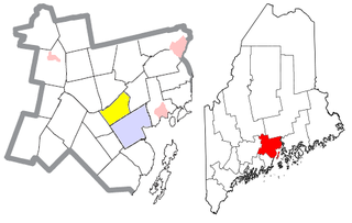
Camden is a census-designated place (CDP) comprising the main village in the town of Camden in Knox County, Maine, United States. The population was 3,570 at the 2010 census, out of 4,850 in the entire town of Camden.

Unity is a town in Waldo County, Maine, United States. The population was 2,292 at the 2020 census. The town is the service center for the northern portion of Waldo County. Outside of Waldo County, it is best known as the home of the Maine Organic Farmers and Gardeners Association, its Common Ground Country Fair and Unity College. Unity College was founded in 1965 to offset the economic effects of the declining chicken farming industry. As of 2007, the college is the town's largest employer.

References

  1. "Town Administrator". Town of Lincolnville, Maine. Retrieved March 22, 2018.
  2. 1 2 "US Gazetteer files 2010". United States Census Bureau . Retrieved December 16, 2012.
  3. "Census - Geography Profile: Lincolnville town, Waldo County, Maine" . Retrieved January 17, 2022.
  4. 1 2 "My Life in Lincolnville". Down East Magazine. August 30, 2012. Retrieved April 2, 2022.
  5. Coolidge, Austin J.; John B. Mansfield (1859). A History and Description of New England. Boston: A.J. Coolidge. p.  195. coolidge mansfield history description new england 1859.
  6. "Lincolnville | Maine: An Encyclopedia". January 10, 2012. Retrieved April 2, 2022.
  7. Comprehensive Plan Review Committee (March 2006). "TOWN OF LINCOLNVILLE, MAINE Comprehensive Plan" (PDF). Main Farmland Trust. Retrieved January 23, 2018.
  8. "Census of Population and Housing". Census.gov. Retrieved June 4, 2015.
  9. "U.S. Census website". United States Census Bureau . Retrieved December 16, 2012.
  10. "U.S. Census website". United States Census Bureau . Retrieved January 31, 2008.
  11. "Kate Clark". Union #69. Retrieved October 4, 2017.
  12. "Maria Libby". Five Town CSD. Retrieved October 4, 2017.
  13. lcs.fivetowns.net/staff_directory
  14. "Phish's New Harmony: How America's Greatest Jam Band Learned to Get Along". rollingstone.com. October 21, 2016. Retrieved October 21, 2016.

44°16′52″N69°00′31″W / 44.28111°N 69.00861°W / 44.28111; -69.00861