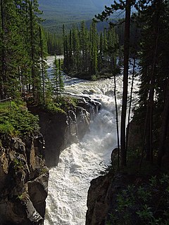
The Sunwapta River is a major tributary of the Athabasca River in Jasper National Park in Alberta, Canada.

Seebe is a former hamlet in Alberta, Canada, within the Municipal District of Bighorn No. 8. It is a former Calgary Power Company Ltd. employee townsite that was closed on August 31, 2004.

The North Saskatchewan River is a glacier-fed river that flows from the Canadian Rockies continental divide east to central Saskatchewan, where it joins with another major river to make up the Saskatchewan River. Its water flows eventually into the Hudson Bay.

Abraham Lake, also known as Lake Abraham, is an artificial lake and Alberta's largest reservoir. It is located in the "Kootenay Plains area of the Canadian Rockies' front range", on the North Saskatchewan River in western Alberta, Canada.

Alberta's Rockies comprises the Canadian Rocky Mountains in Alberta, Canada. It is a region on the southwestern part of the province, along the British Columbia border. It covers all but the south of Census Division 15.
Cardinal River is a short river in western Alberta, Canada. It flows from the Canadian Rockies, and empties into the Brazeau River, itself a major tributary of the North Saskatchewan River.

The Siffleur River is a short river rising in the Canadian Rockies in western Alberta. The Siffleur River is an early tributary of the North Saskatchewan River.

The Chaba River is a short river in western Alberta, Canada. It flows from the Canadian Rockies, and joins the Athabasca River.

Bighorn Dam is a dam located in Clearwater County in west-central Alberta, Canada. It was built by Calgary Power in 1972, and led to the creation of Lake Abraham, Alberta's largest man-made lake. The dam and associated hydroelectric plant are managed by TransAlta.

Crescent Falls are a series of two waterfalls located on the Bighorn River in west-central Alberta, Canada. They were originally called the Bighorn Falls, after the river they are located on.

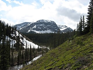
Nigel Creek is a short stream located in the Canadian Rockies of Alberta, Canada. It forms in the glacial meltwaters north of Sunwapta Pass and takes on streams flowing from Nigel Pass.

The Fiddle River is a medium-sized tributary of the Athabasca River, flowing into the river near the east gate of Jasper National Park in Alberta, Canada. The Fiddle River forms at the base of Fiddle Pass, with meltwater from Mount Bryant, Mount Gregg, Mount Sir Harold Mitchel, and Mount Barry. The river flows in a general northeast direction before its confluence with the Athabasca. The Fiddle River parallels the road to the popular Miette Hotsprings for a portion of its course.
The Maligne River is a medium-sized river in the Canadian Rockies. It runs through parts of Jasper National Park in Alberta, Canada. The Maligne is a major tributary of the Athabasca River. The river takes from the French word for malignant or wicked. It is theorised that a Belgian priest voyageur created this name in reference to the current of the river near its confluence with the Athabasca River.
The Assineau River is a short river forming in central Alberta. The Assineau flows into Lesser Slave Lake, which flows out through the Lesser Slave River, a major tributary of the Athabasca River. The name for the river was in use by 1904. It is suggested that Assineau is a version of the Cree word for nobody.

The Driftpile River is a medium-length river forming in central Alberta. The Drifpile flows into Lesser Slave Lake, which flows out through the Lesser Slave River, a major tributary of the Athabasca River. The Geological Survey of Canada was using the name Driftpile by 1892. The river was named because of the large amount of driftwood that collected at the river's mouth.
See also Marten River, Ontario
The Jackpine River is an early tributary of the Smoky River. It forms in the Canadian Rockies, within Willmore Wilderness Park, in the province of Alberta, north of Jasper National Park. The river collects the runoff from Resthaven Mountain, Barricade Mountain, Jackpine Mountain, Mount Holmes, Perseverance Mountain, and Draco Peak.
The Muddywater River is an early tributary of the Smoky River. It forms in the Canadian Rockies, within Willmore Wilderness Park, in the province of Alberta, north of Jasper National Park. The Muddywater forms at Morkill Pass, on the Continental Divide between Alberta and British Columbia.
The Snake Indian River is a large tributary of the Athabasca River, exiting entirely within Jasper National Park. The Snake Indian forms at Snake Indian Pass, south of Monte Christo Mountain and Snake Indian Mountain, north of Calumet Peak. The river travels in a general northwest direction before turning sharply south. The river plummets over the massive Snake Indian Falls before joining the Athabasca River downstream of Jasper Lake, near the east gate of Jasper National Park.

The Snaring River is a medium-sized river in the Canadian Rockies. It runs through parts of Jasper National Park in Alberta, Canada. The Snaring River is a significant tributary of the Athabasca River. The Snaring is named after a former local tribe of first nations people who lived in dugouts and trapped animals with snares.


