
Islesboro is a town in Waldo County, Maine, United States, comprising Islesboro Island and several smaller islands. The population was 583 at the 2020 census. It has a summer colony accessible by state ferry service from Lincolnville Beach three miles to the west, by private boat, or by air taxi service. Home to Warren Island State Park, Islesboro includes the village of Dark Harbor.
Criehaven is an alternative name for Ragged Island, an unorganized territory in Knox County, Maine, United States. Criehaven was formerly a plantation including Ragged Island just south of Matinicus Isle in outer Penobscot Bay, plus Matinicus Rock to its southeast, and Seal Island, the location of Seal Island National Wildlife Refuge, to its northeast. Criehaven surrendered its organization and reverted to an unorganized territory in 1925, but the name persists.

Bowdoin College is a private liberal arts college in Brunswick, Maine. When Bowdoin was chartered in 1794, Maine was still a part of the Commonwealth of Massachusetts. The college offers 34 majors and 36 minors, as well as several joint engineering programs with Columbia, Caltech, Dartmouth College, and the University of Maine.
The Penobscot are an Indigenous people in North America from the Northeastern Woodlands region. They are organized as a federally recognized tribe in Maine and as a First Nations band government in the Atlantic provinces and Quebec.

Casco Bay is an inlet of the Gulf of Maine on the southern coast of Maine, New England, United States. Its easternmost approach is Cape Small and its westernmost approach is Two Lights in Cape Elizabeth. The city of Portland sits along its southern edge and the Port of Portland lies within.

Machias Seal Island is an island in disputed water between the Gulf of Maine and the Bay of Fundy, about 16 km (10 mi) southeast from Cutler, Maine, and 19 km (12 mi) southwest of Grand Manan Island, New Brunswick. Sovereignty of the island is disputed by the United States and Canada. The Canadian Coast Guard continues to staff a lighthouse on the island; the first lighthouse was constructed there in 1832.

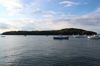
Penobscot Bay is an inlet of the Gulf of Maine and Atlantic Ocean in south central Maine. The bay originates from the mouth of Maine's Penobscot River, downriver from Belfast. Penobscot Bay has many working waterfronts including Rockland, Rockport, and Stonington, and Belfast upriver. Penobscot Bay is between Muscongus Bay and Blue Hill Bay, just west of Acadia National Park.

Cushing Island, or Cushing's Island, is a privately owned island in Casco Bay in the U.S. state of Maine. Part of the city of Portland, Maine, roughly 45 families live there seasonally.
Bar Island is a tidal island across from Bar Harbor on Mount Desert Island, Maine, United States. The uninhabited island is mostly forested in pine and birch trees and the island is now part of Acadia National Park. There are walking trails on the island.

The North Maine Woods is the northern geographic area of the state of Maine in the United States. The thinly populated region is overseen by a combination of private individual and private industrial owners and state government agencies, and is divided into 155 unincorporated townships within the NMW management area. There are no towns or paved roads.
Sears Island, known as Wassumkeag or shining beach by the indigenous Wabanaki tribes of northern New England, is located off the coast of Searsport in Waldo County, Maine, at the top of Penobscot Bay. The island is the largest undeveloped, uninhabited, causeway-accessible island on the eastern coast of the United States. It is 940 acres (3.8 km2) in area. It is part of the Town of Searsport.

Capt. Christopher Levett was an English writer, explorer and naval captain, born at York, England. He explored the coast of New England and secured a grant from the king to settle present-day Portland, Maine, the first European to do so. Levett left behind a group of settlers at his Maine plantation in Casco Bay, but they were never heard from again. Their fate is unknown. As a member of the Plymouth Council for New England, Levett was named the Governor of Plymouth in 1623 and a close adviser to Capt. Robert Gorges in his attempt to found an early English colony at Weymouth, Massachusetts, which also failed. Levett was also named an early governor of Virginia in 1628, according to Parliamentary records at Whitehall.
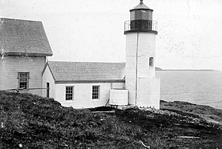
Narraguagus Light is a lighthouse on Pond Island at the southern extent of Narraguagus Bay in Downeast Maine. It was built as an aid to navigation for the bay, and the port of Milbridge, then an important deep-water shipbuilding port. It was deactivated in 1934, and is now privately owned. It was listed on the National Register of Historic Places as "Narraguagus Light Station" on November 20, 1987.
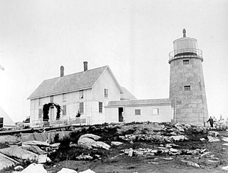
Whitehead Light is a lighthouse on Whitehead Island, on Muscle Ridge Channel, in the southwestern entrance to Penobscot Bay, Maine. It is in the town of St.George. Established in 1804, it is one of Maine's oldest light stations, with its present tower built in 1852 to a design attributed to Alexander Parris. It was listed on the National Register of Historic Places as Whitehead Light Station on March 14, 1988. The property is now owned by not for profit Pine Island Camp. Whitehead light station offers to the public various stays at the light station from getaway weekends to learning retreats and renting the station as a vacation home. The light itself remains an active aid to navigation, maintained by the United States Coast Guard.

Ragged Island is a privately owned island in Harpswell, Maine, in Cumberland County, Maine, which is geographically within Casco Bay in the Gulf of Maine. It is located at 43°43′39″N69°56′13″W.
Wohoa Bay is a bay on the coast of Washington County, Maine. It is located between the towns of Addison and Jonesport. It features a coastal plateau bog ecosystem not found anywhere else in North America. Three rare species have been found in Wohoa Bay, including the crowberry, blue butterfly and bald eagle. Both West River and Indian River drain into Wohoa Bay.
Hawaii 2 is a six-acre (2.4 ha) private island in St. George Lake, Liberty, Maine, United States. Previously used as de facto public land, in 2014 the island was purchased by Cards Against Humanity LLC as part of a fundraiser for the Sunlight Foundation. After licensing the island for use by those who contributed to the campaign, the town of Liberty threatened the games company with hundreds-of-millions in fines for code violations.
The Birch Island House is the centerpiece of a historic sporting camp on Birch Island, located in Holeb Pond in northwestern Somerset County, Maine, United States. Estimated to have been built around 1870, it is a rare surviving element of a 19th-century private camp in the state, when most surviving period camps were commercially run. The building was listed on the National Register of Historic Places in 1996. As of recent the porch has caved in and the structural integrity is questioned.
