Fort Schuyler is a preserved 19th century fortification in the New York City borough of the Bronx. It houses a museum, the Stephen B. Luce Library, and the Marine Transportation Department and Administrative offices of the State University of New York Maritime College. It is considered one of the finest examples of early 19th century fortifications. The fort was named in honor of Major General Philip Schuyler of the Continental Army.

Fort William and Mary was a colonial fortification in Britain's worldwide system of defenses, defended by soldiers of the Province of New Hampshire who reported directly to the royal governor. The fort, originally known as "The Castle," was situated on the island of New Castle, New Hampshire, at the mouth of the Piscataqua River estuary. It was renamed Fort William and Mary circa 1692, after the accession of the monarchs William III and Mary II to the British throne. It was captured by Patriot forces, recaptured, and later abandoned by the British in the Revolutionary War. The fort was renamed Fort Constitution in 1808 following rebuilding. The fort was further rebuilt and expanded through 1899 and served actively through World War II.

Fort Knox, now Fort Knox State Park or Fort Knox State Historic Site, is located on the western bank of the Penobscot River in the town of Prospect, Maine, about 5 miles (8.0 km) from the mouth of the river. Built between 1844 and 1869, it was the first fort in Maine built entirely of granite; most previous forts used wood, earth, and stone. It is named after Major General Henry Knox, the first U.S. Secretary of War and Commander of Artillery during the American Revolutionary War, who at the end of his life lived not far away in Thomaston. As a virtually intact example of a mid-19th century granite coastal fortification, it was added to the National Register of Historic Places in 1969 and declared a National Historic Landmark on December 30, 1970. Fort Knox also serves as the entry site for the observation tower of the Penobscot Narrows Bridge that opened to the public in 2007.

Fort Moultrie is a series of fortifications on Sullivan's Island, South Carolina, built to protect the city of Charleston, South Carolina. The first fort, formerly named Fort Sullivan, built of palmetto logs, inspired the flag and nickname of South Carolina, as "The Palmetto State". The fort was renamed for the U.S. patriot commander in the Battle of Sullivan's Island, General William Moultrie. During British occupation, in 1780–1782, the fort was known as Fort Arbuthnot.

Fort McClary is a former defensive fortification of the United States military located along the southern coast at Kittery Point, Maine at the mouth of the Piscataqua River. It was used throughout the 19th century to protect approaches to the harbor of Portsmouth, New Hampshire and the Portsmouth Naval Shipyard in Kittery. The property and its surviving structures are now owned and operated by the State of Maine as Fort McClary State Historic Site, including a blockhouse dating from 1844.
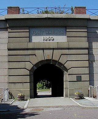
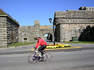
Fort Warren is a historic fort on the 28-acre (110,000 m2) Georges Island at the entrance to Boston Harbor. The fort is named for Revolutionary War hero Dr. Joseph Warren, who sent Paul Revere on his famous ride, and was later killed at the Battle of Bunker Hill. The name was transferred in 1833 from the first Fort Warren – built in 1808 – which was renamed Fort Winthrop.

Fort Gorges is a former United States military fort built on Hog Island Ledge in Casco Bay, Maine. Built from 1858 to 1864, no battles were fought there and no troops were stationed there. Advancing military technology, including iron clad ships and long range guns, made the fort obsolete before it could be used. The fort is now a park, accessible only by boat. It was added to the National Register of Historic Places in 1973.
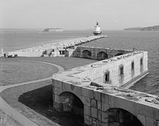
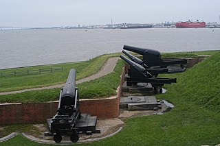
Fort Preble was a military fort in South Portland, Maine, United States, built in 1808 and progressively added to through 1906. The fort was active during all major wars from the War of 1812 through World War II. The fort was deactivated in 1950. It is now on the campus of Southern Maine Community College.
Munjoy Hill is a neighborhood and prominent geographical feature of Portland, Maine. It is located east of downtown and south of East Deering, the neighborhood it is connected to by Tukey's Bridge. The neighborhood historically had a large Irish and Italian American population.

Fort Baldwin is a former coastal defense fortification near the mouth of the Kennebec River in Phippsburg, Maine, United States, preserved as the Fort Baldwin State Historic Site. It was named after Jeduthan Baldwin, an engineer for the Continental Army during the American Revolution. The fort was constructed between 1905 and 1912 and originally consisted of three batteries. The site was listed on the National Register of Historic Places in 1979.

Fort Popham is a Civil War-era coastal defense fortification at the mouth of the Kennebec River in Phippsburg, Maine. It is located in sight of the short-lived Popham Colony and, like the colony, named for George Popham, the colony's leader.
Seacoast defense was a major concern for the United States from its independence until World War II. Before airplanes, many of America's enemies could only reach it from the sea, making coastal forts an economical alternative to standing armies or a large navy. After the 1940s, it was recognized that fixed fortifications were obsolete and ineffective against aircraft and missiles. However, in prior eras foreign fleets were a realistic threat, and substantial fortifications were built at key locations, especially protecting major harbors.

Fort Levett was a former U.S. Army fort built on Cushing Island, Maine, beginning in 1898. Located in Cumberland County, Maine, in Casco Bay near Portland, Maine, the fort was heavily fortified with guns for coastal defense. Conceived under the Endicott Program in 1885 and begun in the wake of the Spanish–American War, Fort Levett was manned during both world wars. It was part of the Coast Defenses of Portland, later renamed the Harbor Defenses of Portland, a command which protected Portland's port and naval anchorage 1904-1950. The fort's name is sometimes misspelled as "Fort Leavitt".

Jewell Island is a small island in Casco Bay, Maine, United States. About 1 mile (1.6 km) long from SW to NE, it is located off the coast of Cliff Island, approximately 8 miles from downtown Portland, Maine. It is a state-owned island with a small but protected harbor as well as camping and walking paths. Jewell Island was part of the Harbor Defenses of Portland fort network. The island is part of the city of Portland. Jewell Island can be reached by private or charter boats. There is no ferry service to the island.

Fort Williams is a former United States Army fort in Cape Elizabeth, Maine which operated from 1872 to 1964. It was part of the Coast Defenses of Portland, later renamed the Harbor Defenses of Portland, a command which protected Portland's port and naval anchorage 1904–1950. After its closure, it was redeveloped into Fort Williams Park.

Fort McKinley is a former United States Army coastal defense fort on Great Diamond Island, Maine in Casco Bay, which operated from 1873 to 1947. It was named for President William McKinley. It included a sub-post, Fort Lyon, on Cow Island, just north of Great Diamond Island. Fort Lyon was named for Nathaniel Lyon. Both forts were part of the Coast Defenses of Portland, renamed the Harbor Defenses of Portland in 1925, a command which protected Portland's port and naval anchorage 1895-1950. In 1946 Fort Lyon was closed and turned over to the City of Portland. After Fort McKinley's closure it was transferred to the United States Navy, which sold the site to private interests in 1961. The Fort McKinley Historic District was listed on the National Register of Historic Places in 1985.

Battery Steele is a United States military fortification on Peaks Island, Portland, Maine in Casco Bay. Completed in 1942 as part of World War II, it is located on 14 acres (5.7 ha) on the oceanside area of the island, formerly part of the Peaks Island Military Reservation. It is named for Harry L. Steele, who was a Coast Artillery officer during World War I. It was armed with two 16-inch MkIIMI guns and, with a 12-inch gun battery at Fort Levett on Cushing Island, replaced all previous heavy guns in the Harbor Defenses of Portland. It was built to protect Casco Bay, particularly Portland harbor, from Kennebunk to Popham Beach in Phippsburg. According to Kim MacIsaac and historian Joel Eastman in An Island at War, “Battery Steele is not only the largest gun battery built on Peaks Island, but also an example of the largest battery ever built anywhere in the United States.” In 1995, after decades of non-use, the Peaks Island Land Preserve, a community land preservation group, formed to purchase the area and forever preserve it as a public space. On October 20, 2005, the property was listed on the National Register of Historic Places. Other coast defense structures on the island include fire control towers and the counterweight for a disappearing searchlight tower.

The Harbor Defenses of Portland was a United States Army Coast Artillery Corps harbor defense command. It coordinated the coast defenses of Portland, Maine, the mouth of the Kennebec River, and surrounding areas from 1895 to 1950, beginning with the Endicott program. These included both coast artillery forts and underwater minefields. The command originated circa 1895 as the Portland Artillery District, was renamed Coast Defenses of Portland in 1913, and again renamed Harbor Defenses of Portland in 1925.
The Harbor Defenses of Portsmouth was a United States Army Coast Artillery Corps harbor defense command. It coordinated the coast defenses of Portsmouth, New Hampshire and the nearby Portsmouth Naval Shipyard in Kittery, Maine from 1900 to 1950, both on the Piscataqua River, beginning with the Endicott program. These included both coast artillery forts and underwater minefields. The command originated circa 1900 as the Portsmouth Artillery District, was renamed Coast Defenses of Portsmouth in 1913, and again renamed Harbor Defenses of Portsmouth in 1925.


