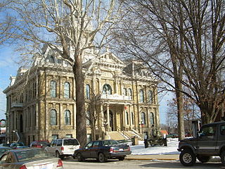
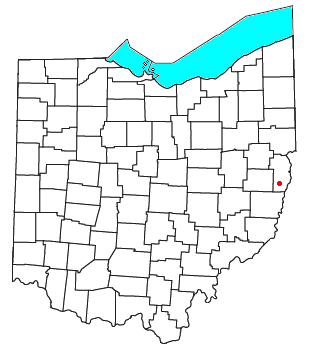
Guernsey County is a county located in the U.S. state of Ohio. As of the 2020 census, the population was 38,438. Its county seat and largest city is Cambridge. It is named for the Isle of Guernsey in the English Channel, from which many of the county's early settlers emigrated.

Locust Fork is a town in Blount County, Alabama, United States. At the 2010 census the population was 1,186 people, up from 1,016 in 2000.

U.S. Route 21 or U.S. Highway 21 (US 21) is a major north–south United States Numbered Highway in the Southeastern United States that extends 394 miles (634 km). The southern terminus is in Hunting Island State Park, South Carolina, 14.4 miles (23.2 km) south of the junction with US 21 Business and South Carolina Highway 802 (SC 802) in Beaufort. The northern terminus is in Wytheville, Virginia, at an interchange with Interstate 81 (I-81) and US 52. Despite the "1" indicating that it is a major north–south highway, US 21 only travels through three states and is no longer a cross-country route as it has been replaced with I-77 in both Ohio and West Virginia. It also has the second-shortest length of all of the major north–south routes, just behind US 91. The route travels through the states of South Carolina, North Carolina, and Virginia. It also connects through major Southeastern cities such as Columbia, South Carolina, and Charlotte, North Carolina. The northern portion of the road travels parallel to I-77 in northern South Carolina and North Carolina. The road also has three interchanges with I-26 in Lexington and Calhoun counties in South Carolina.
The Whitewater River is a 101-mile-long (163 km) southerly flowing right tributary of the Great Miami River in southeastern Indiana and southwestern Ohio in the United States. It is formed by the confluence of two forks, the West Fork and East Fork. The name is a misnomer, as there is no true white water on the river. However, there are many rapids due to the steep gradient present - the river falls an average of six feet per mile (1.1 m/km). The gradient rendered upstream navigation impossible, and in the mid-nineteenth century resulted in the construction of the Whitewater Canal paralleling the river from north of Connersville, Indiana, to the Ohio River.

The Fishing River is a 39.0-mile-long (62.8 km) tributary of the Missouri River in western Missouri in the United States. It rises in the northeastern extremity of Kansas City in Clay County and flows generally eastward and southeastward through Clay and southeastern Ray counties, past the town of Mosby. It joins the Missouri River about 3 miles (5 km) south of the town of Orrick.

The Saline River is a tributary of the Ohio River, approximately 27 miles (43 km) long, in the Southern Illinois region of the U.S. state of Illinois. The river drains a large section of southeast Illinois, with a drainage basin of 1,762 square miles (4,564 km2). The major tributaries include the South Fork, Middle Fork and North Fork, all lying within the Saline Valley. The once meandering swampy river was important among Native Americans and early settlers as a source of salt from numerous salt springs where it was commercially extracted in the early 19th century.

Wills Creek is a tributary of the Muskingum River, 92.2 mi (148.4 km) long, in eastern Ohio in the United States. Via the Muskingum and Ohio Rivers, it is part of the watershed of the Mississippi River. It drains an area of 853 mi2 (2,209 km2).

The Sandy and Beaver Canal was a canal and lock transportation system which ran seventy-three miles from the Ohio and Erie Canal at Bolivar, Ohio, to the Ohio River at Glasgow, Pennsylvania.

Derwent is an unincorporated community in central Valley Township, Guernsey County, Ohio, United States. It is located near the southern border of Guernsey and Noble counties.

Salt Fork State Park is a public recreation area located six miles (9.7 km) north of Lore City in Guernsey County, Ohio. It is the largest state park in Ohio, encompassing 17,229 acres (6,972 ha) of land and 2,952 acres (1,195 ha) of water. The grounds include the Kennedy Stone House, which is listed on the National Register of Historic Places. The park is managed by the Ohio Department of Natural Resources Division of Parks and Watercraft.

Harriettsville is an unincorporated community in western Elk Township, Noble County, Ohio, United States. It lies along State Route 145 at its intersection with County Road 46. The East Fork of Duck Creek, a subsidiary of the Ohio River that meets the river near Marietta, runs along State Route 145 past the community. It lies 8 miles (13 km) northeast of Lower Salem by road, and 13 miles (21 km) directly southeast of Caldwell, the county seat of Noble County.
Greentown is an unincorporated community in eastern Smithfield Township, Jefferson County, Ohio, United States. It lies approximately 2 miles (3.2 km) south of Smithfield, on a small road. Part of the Dry Fork of Short Creek, a stream that meets the Ohio River at Rayland, flows past the community. It is located 11+3⁄4 miles (18.9 km) southwest of Steubenville, the county seat of Jefferson County. The community is part of the Weirton–Steubenville, WV-OH Metropolitan Statistical Area.

Peoli is an unincorporated community in Washington Township, Tuscarawas County, Ohio, United States, along State Route 258.
Dohrman Tract or Dohrman’s Grant was a land tract in eastern Ohio granted by Congress to Arnold Henry Dohrman (1749–1813), who helped the American cause in the Revolutionary War.
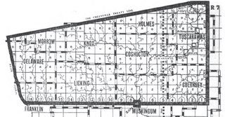
The United States Military District was a land tract in central Ohio that was established by the Congress to compensate veterans of the American Revolutionary War for their service. The tract contains 2,539,110 acres (10,275.4 km2) in Noble, Guernsey, Tuscarawas, Muskingum, Coshocton, Holmes, Licking, Knox, Franklin, Delaware, Morrow, and Marion counties.

The Salt Reservations were a collection of land tracts surrounding salt springs in Ohio and some other states that were donated to the states by the federal government early in the 19th century.
Cinnamon Lake is a census-designated place (CDP) within Jackson Township, Ashland County, Ohio, United States. The population was 1,237 at the 2020 census. It consists of a planned community surrounding a 135-acre (0.55 km2) reservoir also named Cinnamon Lake.

Antrim is an unincorporated community in Guernsey County, in the U.S. state of Ohio.

The Ohio and Erie Canal Towpath Trail is a multi-use trail that follows part of the former route of the Ohio & Erie Canal in Northeast Ohio.

Skull Fork is a stream in the U.S. state of Ohio.

